Guadalupe Group

Last updated
Guadalupe Group
Stratigraphic range: Campanian-Maastrichtian
~80–70  Ma
Santuario de Guadalupe vista desde Monserrate.JPG
Guadalupe Hill
Type locality of the Guadalupe Group
Type Geological group
Sub-units Arenisca Labor-Tierna
Plaeners
Arenisca Dura
Underlies Guaduas Formation
Overlies Villeta Group
  Conejo Fm. & Chipaque Fm.
Lithology
Primary Sandstone, shale
Other Salt (allochthonous)
Location
Coordinates 4°35′31″N74°03′15″W / 4.59194°N 74.05417°W / 4.59194; -74.05417
Region Altiplano Cundiboyacense
Eastern Ranges, Andes
Country Colombia
Type section
Named for Guadalupe Hill
Named byPérez & Salazar
Year defined1978
Coordinates 4°35′31″N74°03′15″W / 4.59194°N 74.05417°W / 4.59194; -74.05417
Region Cundinamarca, Boyacá
Country Colombia
Thickness at type section750 metres (2,460 ft)
Blakey 065Ma - COL.jpg
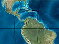
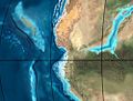
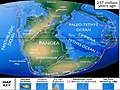
Paleogeography of Northern South America
65 Ma, by Ron Blakey

The Guadalupe Group (Spanish : Grupo Guadalupe, K2G, Ksg) is a geological group of the Altiplano Cundiboyacense, Eastern Ranges of the Colombian Andes. The group, a sequence of shales and sandstones, is subdivided into three formations; Arenisca Dura, Plaeners and Arenisca Labor-Tierna, and dates to the Late Cretaceous period; Campanian-Maastrichtian epochs and at its type section has a thickness of 750 metres (2,460 ft).

Contents

Etymology

The group was published in 1978 by Pérez and Salazar and named after its type locality Guadalupe Hill in the Eastern Hills of Bogotá. [1]

Description

Lithologies

The Guadalupe Group is characterised by three formations; two sandstone sequences, Arenisca Dura and Arenisca Labor-Tierna, and an intermediate shale formation; Plaeners. [1]

Stratigraphy and depositional environment

The Guadalupe Group overlies the Conejo Formation in the central part of the Altiplano Cundiboyacense and the Chipaque Formation in the eastern part and is overlain by the Guaduas Formation. Some authors define the Guadalupe Group as a formation and call the individual formations members. [2] The thickness of the Guadalupe Group in its type locality Guadalupe Hill and the El Cable Hill is 750 metres (2,460 ft). [3] The age has been estimated to be Campanian-Maastrichtian. [4] The Guadalupe Group has been deposited in a marine environment. [5]

Outcrops

Sabana de Bogota.png
Green pog.svg
Type locality of the Guadalupe Group to the east of the Bogotá savanna

The formations of the Guadalupe Group are apart from its type locality at Guadalupe Hill, Bogotá, found in other parts of the Eastern Hills of Bogotá, the Ocetá Páramo and many other locations, such as the Piedras del Tunjo in the Eastern Ranges. [4] [6]

At present, the Guadalupe Group in the anticlinals of Zipaquirá and Nemocón contains rock salt. These halite deposits are not originally deposited in the Late Cretaceous Guadalupe Group, yet are allochthonous diapirs formed when the Jurassic-Lower Cretaceous normal faults were reactivated as reverse faults during the mayor Miocene tectonic movements of the Eastern Ranges. [7] The salt had been deposited during the Early Cretaceous (Valanginian-Barremian, approximately 135 to 125 Ma), [8] intruding into the overlying formations of the Upper Cretaceous. [9]

Regional correlations

Stratigraphy of the Llanos Basin and surrounding provinces
Ma AgePaleomapRegional events Catatumbo Cordillera proximal Llanos distal Llanos Putumayo VSM Environments Maximum thicknessPetroleum geologyNotes
0.01 Holocene
Blakey 000Ma - COL.jpg
Holocene volcanism
Seismic activity
alluvium Overburden
1 Pleistocene
Blakey Pleist - COL.jpg
Pleistocene volcanism
Andean orogeny 3
Glaciations
Guayabo Soatá
Sabana
Necesidad Guayabo Gigante
Alluvial to fluvial (Guayabo)550 m (1,800 ft)
(Guayabo)
[10] [11] [12] [13]
2.6 Pliocene
Blakey 020Ma - COL.jpg
Pliocene volcanism
Andean orogeny 3
GABI
Subachoque
5.3 Messinian Andean orogeny 3
Foreland
Marichuela Caimán Honda [12] [14]
13.5 Langhian Regional flooding León hiatus Caja León Lacustrine (León)400 m (1,300 ft)
(León)
Seal [13] [15]
16.2 Burdigalian Miocene inundations
Andean orogeny 2
C1 Carbonera C1 Ospina Proximal fluvio-deltaic (C1)850 m (2,790 ft)
(Carbonera)
Reservoir [14] [13]
17.3 C2 Carbonera C2 Distal lacustrine-deltaic (C2) Seal
19 C3 Carbonera C3 Proximal fluvio-deltaic (C3) Reservoir
21 Early Miocene Pebas wetlands C4 Carbonera C4 Barzalosa Distal fluvio-deltaic (C4) Seal
23 Late Oligocene
Blakey 035Ma - COL.jpg
Andean orogeny 1
Foredeep
C5 Carbonera C5 Orito Proximal fluvio-deltaic (C5) Reservoir [11] [14]
25 C6 Carbonera C6 Distal fluvio-lacustrine (C6) Seal
28 Early Oligocene C7 C7 Pepino Gualanday Proximal deltaic-marine (C7) Reservoir [11] [14] [16]
32Oligo-Eocene C8 Usme C8 onlapMarine-deltaic (C8) Seal
Source
[16]
35 Late Eocene
Blakey 050Ma - COL.jpg
Mirador Mirador Coastal (Mirador)240 m (790 ft)
(Mirador)
Reservoir [13] [17]
40 Middle Eocene Regadera hiatus
45
50 Early Eocene
Blakey 065Ma - COL.jpg
Socha Los Cuervos Deltaic (Los Cuervos)260 m (850 ft)
(Los Cuervos)
Seal
Source
[13] [17]
55 Late Paleocene PETM
2000 ppm CO2
Los Cuervos Bogotá Gualanday
60 Early Paleocene SALMA Barco Guaduas Barco Rumiyaco Fluvial (Barco)225 m (738 ft)
(Barco)
Reservoir [10] [11] [14] [13] [18]
65 Maastrichtian
Blakey 090Ma - COL.jpg
KT extinction Catatumbo Guadalupe Monserrate Deltaic-fluvial (Guadalupe)750 m (2,460 ft)
(Guadalupe)
Reservoir [10] [13]
72 Campanian End of rifting Colón-Mito Juan [13] [19]
83 Santonian Villeta/Güagüaquí
86 Coniacian
89 Turonian Cenomanian-Turonian anoxic event La Luna Chipaque Gachetá hiatusRestricted marine (all)500 m (1,600 ft)
(Gachetá)
Source [10] [13] [20]
93 Cenomanian
Blakey 105Ma - COL.jpg
Rift 2
100 Albian Une Une Caballos Deltaic (Une)500 m (1,600 ft)
(Une)
Reservoir [14] [20]
113 Aptian
Blakey 120Ma - COL.jpg
Capacho Fómeque Motema Yaví Open marine (Fómeque)800 m (2,600 ft)
(Fómeque)
Source (Fóm) [11] [13] [21]
125 Barremian High biodiversity Aguardiente Paja Shallow to open marine (Paja)940 m (3,080 ft)
(Paja)
Reservoir [10]
129 Hauterivian
Blakey 150Ma - COL.jpg
Rift 1 Tibú-
Mercedes
Las Juntas hiatus Deltaic (Las Juntas)910 m (2,990 ft)
(Las Juntas)
Reservoir (LJun) [10]
133 Valanginian Río Negro Cáqueza
Macanal
Rosablanca
Restricted marine (Macanal)2,935 m (9,629 ft)
(Macanal)
Source (Mac) [11] [22]
140 Berriasian Girón
145 Tithonian Break-up of Pangea Jordán Arcabuco Buenavista
Saldaña Alluvial, fluvial (Buenavista)110 m (360 ft)
(Buenavista)
"Jurassic" [14] [23]
150 Early-Mid Jurassic
Blakey 170Ma - COL.jpg
Passive margin 2 La Quinta
Noreán
hiatusCoastal tuff (La Quinta)100 m (330 ft)
(La Quinta)
[24]
201 Late Triassic
Blakey 200Ma - COL.jpg
Mucuchachi Payandé [14]
235 Early Triassic
237 Ma orogenies reconstruction.jpg
Pangea hiatus"Paleozoic"
250 Permian
280 Ma plate tectonic reconstruction.png
300 Late Carboniferous
Laurasia 330Ma.jpg
Famatinian orogeny Cerro Neiva
()
[25]
340 Early Carboniferous Fossil fish
Romer's gap
Cuche
(355-385)
Farallones
()
Deltaic, estuarine (Cuche)900 m (3,000 ft)
(Cuche)
360 Late Devonian
380 Ma plate tectonic reconstruction.png
Passive margin 1 Río Cachirí
(360-419)
Ambicá
()
Alluvial-fluvial-reef (Farallones)2,400 m (7,900 ft)
(Farallones)
[22] [26] [27] [28] [29]
390 Early Devonian
Gondwana 420 Ma.png
High biodiversity Floresta
(387-400)
Shallow marine (Floresta)600 m (2,000 ft)
(Floresta)
410 Late Silurian Silurian mystery
425 Early Silurian hiatus
440 Late Ordovician
Middle Ordovician South Polar paleogeography - 460 Ma.png
Rich fauna in Bolivia San Pedro
(450-490)
Duda
()
470 Early Ordovician First fossils Busbanzá
(>470±22)
Guape
()
Río Nevado
()
Agua Blanca
Venado
(470-475)
[30] [31] [32]
488 Late Cambrian
kyaambriy'aan50.png
Regional intrusions Chicamocha
(490-515)
Quetame
()
Ariarí
()
SJ del Guaviare
(490-590)
San Isidro
()
[33] [34]
515 Early Cambrian Cambrian explosion [32] [35]
542 Ediacaran
Positions of ancient continents, 550 million years ago.jpg
Break-up of Rodinia pre-Quetamepost-Parguaza El Barro
()
Yellow: allochthonous basement
(Chibcha terrane)
Green: autochthonous basement
(Río Negro-Juruena Province)
Basement [36] [37]
600 Neoproterozoic Cariri Velhos orogeny Bucaramanga
(600-1400)
pre-Guaviare [33]
800
Pannotia - 2.png
Snowball Earth [38]
1000 Mesoproterozoic
Paleoglobe NO 1260 mya.gif
Sunsás orogeny Ariarí
(1000)
La Urraca
(1030-1100)
[39] [40] [41] [42]
1300 Rondônia-Juruá orogeny pre-Ariarí Parguaza
(1300-1400)
Garzón
(1180-1550)
[43]
1400
Paleoglobe NO 1590 mya-vector-colors.svg
pre-Bucaramanga [44]
1600 Paleoproterozoic Maimachi
(1500-1700)
pre-Garzón [45]
1800
2050ma.png
Tapajós orogeny Mitú
(1800)
[43] [45]
1950 Transamazonic orogeny pre-Mitú [43]
2200 Columbia
2530 Archean
Kenorland.jpg
Carajas-Imataca orogeny [43]
3100 Kenorland
Sources
Legend

Panorama

Panorama Cerro de Aguilas - Paramo de Oceta.jpg
The Cerro de Águilas on the Ocetá Páramo is composed of sediments belonging to the Guadalupe Group

See also

GA candidate.svg Geology of the Eastern Hills
Symbol b class.svg Geology of the Ocetá Páramo
Symbol c class.svg Geology of the Altiplano Cundiboyacense

Notes

  1. based on Duarte et al. (2019) [46] , García González et al. (2009), [47] and geological report of Villavicencio [48]
  2. based on Duarte et al. (2019) [46] and the hydrocarbon potential evaluation performed by the UIS and ANH in 2009 [49]

References

  1. 1 2 Montoya Arenas & Reyes Torres, 2005, p.37
  2. Guerrero Uscátegui, 1992, p.4
  3. Guerrero Uscátegui, 1992, p.5
  4. 1 2 Montoya Arenas & Reyes Torres, 2005, pp.38-50
  5. Villamil, 2012, p.164
  6. Plancha 227, 1998
  7. Montoya Arenas & Reyes Torres, 2005, p.98
  8. Guerrero Uscátegui, 1993, p.12
  9. García & Jiménez, 2016, p.24
  10. 1 2 3 4 5 6 García González et al., 2009, p.27
  11. 1 2 3 4 5 6 García González et al., 2009, p.50
  12. 1 2 García González et al., 2009, p.85
  13. 1 2 3 4 5 6 7 8 9 10 Barrero et al., 2007, p.60
  14. 1 2 3 4 5 6 7 8 Barrero et al., 2007, p.58
  15. Plancha 111, 2001, p.29
  16. 1 2 Plancha 177, 2015, p.39
  17. 1 2 Plancha 111, 2001, p.26
  18. Plancha 111, 2001, p.24
  19. Plancha 111, 2001, p.23
  20. 1 2 Pulido & Gómez, 2001, p.32
  21. Pulido & Gómez, 2001, p.30
  22. 1 2 Pulido & Gómez, 2001, pp.21-26
  23. Pulido & Gómez, 2001, p.28
  24. Correa Martínez et al., 2019, p.49
  25. Plancha 303, 2002, p.27
  26. Terraza et al., 2008, p.22
  27. Plancha 229, 2015, pp.46-55
  28. Plancha 303, 2002, p.26
  29. Moreno Sánchez et al., 2009, p.53
  30. Mantilla Figueroa et al., 2015, p.43
  31. Manosalva Sánchez et al., 2017, p.84
  32. 1 2 Plancha 303, 2002, p.24
  33. 1 2 Mantilla Figueroa et al., 2015, p.42
  34. Arango Mejía et al., 2012, p.25
  35. Plancha 350, 2011, p.49
  36. Pulido & Gómez, 2001, pp.17-21
  37. Plancha 111, 2001, p.13
  38. Plancha 303, 2002, p.23
  39. Plancha 348, 2015, p.38
  40. Planchas 367-414, 2003, p.35
  41. Toro Toro et al., 2014, p.22
  42. Plancha 303, 2002, p.21
  43. 1 2 3 4 Bonilla et al., 2016, p.19
  44. Gómez Tapias et al., 2015, p.209
  45. 1 2 Bonilla et al., 2016, p.22
  46. 1 2 Duarte et al., 2019
  47. García González et al., 2009
  48. Pulido & Gómez, 2001
  49. García González et al., 2009, p.60

Bibliography

Maps