The Simijaca Formation (Spanish: Formación Simijaca, K2S, Kss) is a geological formation of the Altiplano Cundiboyacense, Eastern Ranges of the Colombian Andes. The predominantly mudstone formation dates to the Late Cretaceous period; Turonian and Cenomanian epochs, and has a maximum thickness of 693 metres (2,274 ft).
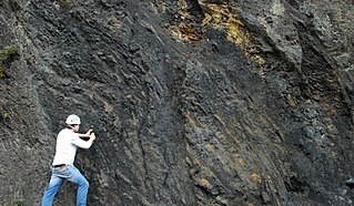
The Chipaque Formation (Spanish: Formación Chipaque, K2cp, Kc) is a geological formation of the Altiplano Cundiboyacense, Eastern Ranges of the Colombian Andes. The predominantly organic shale formation dates to the Late Cretaceous period; Cenomanian-Turonian epochs and has a maximum thickness of 1,700 metres (5,600 ft). The formation, rich in TOC, is an important oil and gas generating unit for the giant oilfields Cupiagua and Cusiana of the Eastern Ranges as well as in the Llanos Orientales.
The Bogotá Formation (Spanish: Formación Bogotá, E1-2b, Tpb, Pgb) is a geological formation of the Eastern Hills and Bogotá savanna on the Altiplano Cundiboyacense, Eastern Ranges of the Colombian Andes. The predominantly shale and siltstone formation, with sandstone beds intercalated, dates to the Paleogene period; Upper Paleocene to Lower Eocene epochs, with an age range of 61.66 to 52.5 Ma, spanning the Paleocene–Eocene Thermal Maximum. The thickness of the Bogotá Formation ranges from 169 metres (554 ft) near Tunja to 1,415 metres (4,642 ft) near Bogotá. Fossils of the ungulate Etayoa bacatensis have been found in the Bogotá Formation, as well as numerous reptiles, unnamed as of 2017.
The La Frontera Formation (Spanish: Formación La Frontera, K2F, Ksf) is a geological formation, part of the Villeta Group, of the Altiplano Cundiboyacense and neighbouring areas of the Eastern Ranges of the Colombian Andes. The sequence of limestones and lydites dates to the Late Cretaceous period; Turonian epoch and has a maximum thickness of 206 metres (676 ft).
The Conejo Formation (Spanish: Formación Conejo, K2C, Kscn) is a fossiliferous geological formation of the Altiplano Cundiboyacense, Eastern Ranges of the Colombian Andes. The uppermost unit of the Villeta Group, a sequence of shales and sandstones dates to the Late Cretaceous period; Turonian, Coniacian and Santonian epochs, and has a maximum thickness of 1,022 metres (3,353 ft).
The Murca Formation is a geological formation of the Altiplano Cundiboyacense, Eastern Ranges of the Colombian Andes. The predominantly subarkose sandstone with claystones and siltstones formation dates to the Early Cretaceous period; Valanginian epoch and has a maximum thickness of 924 metres (3,031 ft).

The Hiló Formation is a geological formation of the Altiplano Cundiboyacense, Eastern Ranges of the Colombian Andes. The predominantly shale formation dates to the Middle Cretaceous period; Late Albian to Early Cenomanian epochs and has a measured thickness at its type section of 470 metres (1,540 ft). The fossiliferous formation has provided a great abundance of ammonites and other marine species.
The Capotes Formation is a geological formation of the Altiplano Cundiboyacense, Eastern Ranges of the Colombian Andes. The formation consists of calcareous black shales containing gypsum and ammonites and dates to the Early Cretaceous period; Early Albian epoch and has an approximate thickness at its type section of 550 metres (1,800 ft).
The Trincheras Formation is a geological formation of the Altiplano Cundiboyacense, Eastern Ranges of the Colombian Andes. The formation consisting of a lower unit of calcareous shales and an upper sequence of shales dates to the Early Cretaceous period; Early Aptian epoch and has a maximum thickness of 1,260 metres (4,130 ft). The formation, deposited in a marine platform environment, part of a transgressive cycle, hosts ammonite, bryozoan, mollusc and echinoid fossils.
The Las Juntas Formation or Las Juntas Sandstone is a geological formation of the Altiplano Cundiboyacense and Tenza Valley, Eastern Ranges of the Colombian Andes. The Las Juntas Formation is found in the departments Cundinamarca, Boyacá and Casanare. The predominantly sandstone formation dates to the Early Cretaceous period; Hauterivian epoch, and has a maximum thickness of 910 metres (2,990 ft).
The Macanal Formation or Macanal Shale is a fossiliferous geological formation of the Altiplano Cundiboyacense and Tenza Valley in the Eastern Ranges of the Colombian Andes. The predominantly organic shale formation dates to the Early Cretaceous period; Berriasian to Valanginian epochs and has a maximum thickness of 2,935 metres (9,629 ft). The Macanal Formation contains numerous levels of fossiliferous abundances. Bivalves, ammonites and fossil flora have been found in the formation.
The Fómeque Formation is a geological formation of the Altiplano Cundiboyacense, Eastern Ranges of the Colombian Andes. The predominantly organic shale formation dates to the Early Cretaceous period; Barremian to Late Aptian epochs and has a maximum thickness of 1,200 metres (3,900 ft).
The La Naveta Formation is a geological formation of the Altiplano Cundiboyacense, Eastern Ranges of the Colombian Andes. The formation consists of a lower part of coraline limestones and an upper sequence of quartzitic sandstones with intercalated black shales and dates to the Early Cretaceous period; Hauterivian to Barremian epochs.
The Guavio Formation is a geological formation of the Altiplano Cundiboyacense, Eastern Ranges of the Colombian Andes. The formation consists of conglomerates, shales and limestones, dates to the Late Jurassic and Early Cretaceous periods; Tithonian to Berriasian epochs and has a maximum thickness of 1,000 metres (3,300 ft).
The Villeta Group is a geological group of the Eastern Ranges of the Colombian Andes, to the west of the Altiplano Cundiboyacense. The group, a sequence of shales, limestones and sandstones, is subdivided into various formations; Conejo, La Frontera, Simijaca, Hiló, Pacho, Chiquinquirá, Capotes, Socotá, El Peñón, and Trincheras, and dates to the Cretaceous period; Aptian-Coniacian epochs. The group stretches out across four departments, from Huila in the south, through Cundinamarca and Boyacá to southern Santander in the north. The upper part of the Villeta Group is time-equivalent with the La Luna Formation of the Middle Magdalena Valley (VMM) and Sierra Nevada del Cocuy, the Oliní and Güagüaquí Groups of the Guaduas-Vélez synclinal and the Chipaque Formation of the Altiplano Cundiboyacense. The lower part has been correlated with the Simití, Tablazo and Paja Formations of the VMM, the upper Tibasosa, Une and Fómeque Formations of the Altiplano Cundiboyacense and the Capacho, Aguardiente, Tibú-Mercedes and upper Río Negro Formations of the Sierra Nevada del Cocuy.
The Loma Gorda Formation is a fossiliferous geological formation of the Upper Magdalena Valley (VSM) and surrounding Central and Eastern Ranges of the Colombian Andes, extending from Cundinamarca in the north to Huila and easternmost Tolima in the south. The uppermost unit of the Güagüaquí Group, a sequence of laminated siltstones and shales, dates to the Late Cretaceous period; Turonian to Coniacian epochs, and has a maximum thickness of 167 metres (548 ft).
The Hondita Formation is a fossiliferous geological formation of the Upper Magdalena Valley (VSM) and surrounding Central and Eastern Ranges of the Colombian Andes, extending from Cundinamarca in the north to Huila and easternmost Tolima in the south. The lowermost unit of the Güagüaquí Group, a sequence of sandy limestones and shales, dates to the Late Cretaceous period; Turonian epoch, and has a maximum thickness of 90 metres (300 ft).
The Oliní Group (Spanish: Grupo Oliní, K3k5o, K2ol, Kso) is a fossiliferous geological group of the VMM, VSM and the eastern flanks of the Central and western flanks of the Eastern Ranges of the Colombian Andes. The regional group stretches from north to south across approximately 700 kilometres (430 mi) and dates to the Late Cretaceous period; Coniacian, Santonian and Campanian epochs, and has a maximum thickness of 287 metres (942 ft). Fossils of Eonatator coellensis have been found in the unit, near Coello, Tolima.
The Caballos Formation is a geological formation of the Upper Magdalena Valley (VSM), Caguán-Putumayo Basin, Central and Eastern Ranges of the Colombian Andes. The sandstone and shale formation dates to the Middle Cretaceous period; Aptian to Albian epochs and has a maximum thickness of 411 metres (1,348 ft).