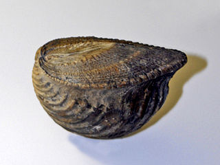
Trigonia is an extinct genus of saltwater clams, fossil marine bivalve mollusk in the family Trigoniidae. The fossil range of the genus spans the Paleozoic, Mesozoic and Paleocene of the Cenozoic, from 298 to 56 Ma.

The Middle Magdalena Valley, Middle Magdalena Basin or Middle Magdalena Valley Basin is an intermontane basin, located in north-central Colombia between the Central and Eastern Ranges of the Andes. The basin, covering an area of 34,000 square kilometres (13,000 sq mi), is situated in the departments of Santander, Boyacá, Cundinamarca and Tolima.

The Tunjuelo Formation, Río Tunjuelo or Río Tunjuelito Formation is a geological formation of the Bogotá savanna, Altiplano Cundiboyacense, Eastern Ranges of the Colombian Andes. The formation consists mainly of conglomerates with intercalating shales and sandstones. The Tunjuelo Formation dates to the Quaternary period; covering the complete Pleistocene epoch, and has a maximum thickness of 150 metres (490 ft). It is a formation of the lacustrine and fluvio-glacial sediments of Lake Humboldt.
The Subachoque Formation is a geological formation of the Bogotá savanna, Altiplano Cundiboyacense, Eastern Ranges of the Colombian Andes. The formation consists mainly of sandy shales and lignite with sandstone beds. The Subachoque Formation dates to the Quaternary period; Early to Middle Pleistocene epoch, and has a maximum thickness of 150 metres (490 ft). It is the lowermost formation of the lacustrine and fluvio-glacial sediments of Lake Humboldt.
Pseudoosterella ubalaensis is an extinct ammonoid cephalopod species belonging to the genus Pseudoosterella in the family of Oosterellidae. These fast-moving nektonic carnivores lived during the Early Cretaceous; Valanginian and Berriasian epochs. The species was first described by Haas in 1960.
The Cacho Formation (Spanish: Formación Cacho, E1C, Tpc, Tec) is a geological formation of the Altiplano Cundiboyacense, Eastern Ranges of the Colombian Andes. The predominantly sandstone formation with thin intercalated beds of shales dates to the Paleogene period; Middle to Late Paleocene epochs, and has a maximum thickness of 400 metres (1,300 ft).

The Usme Formation is a geological formation of the Bogotá savanna, Altiplano Cundiboyacense, Eastern Ranges of the Colombian Andes. The formation consists of a lower part with predominantly shales with intercalated sandstone beds and an upper sequence with sandstones and conglomerates. The Usme Formation dates to the Neogene and Paleogene periods; Late Eocene to Early Oligocene epochs, and has a maximum thickness of 300 metres (980 ft).
The Regadera Formation (Spanish: Formación Regadera, E2r, Tpr) is a geological formation of the Bogotá savanna, Altiplano Cundiboyacense, Eastern Ranges of the Colombian Andes. The predominantly sandstone and conglomeratic formation, with pink shale beds intercalated, dates to the Paleogene period; Middle to Late Eocene epoch, and has a maximum thickness of 765 metres (2,510 ft).
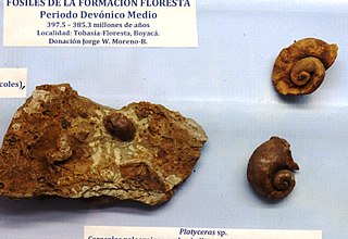
The Floresta Formation is a geological formation of the Altiplano Cundiboyacense in the Eastern Ranges of the Colombian Andes. The sequence of siltstones, shales, coquinas and sandstone beds dates to the Devonian period; Late Emsian, Eifelian and Early Givetian epochs, and has a maximum thickness of 600 metres (2,000 ft). The unit is highly fossiliferous; brachiopods, bryozoans, gastropods, trilobites, corals and bivalves have been found in the Floresta Formation. Some fragments of Placoderm fish fossils were found in the Floresta Formation, while the overlying Cuche Formation is much richer in fish biodiversity.

The Arcabuco Formation is a geological formation of the Altiplano Cundiboyacense, Eastern Ranges of the Colombian Andes. The formation consists of thick beds of light-coloured quartzitic sandstones and conglomerates with occasional shales and dates to the Late Jurassic and Early Cretaceous periods; Tithonian to Berriasian epochs. Dinosaur footprints have been found in the Arcabuco Formation near the Iguaque anticlinal outside Chíquiza, Boyacá.
The Honda Group is a geological group of the Upper and Middle Magdalena Basins and the adjacent Central and Eastern Ranges of the Colombian Andes. The group, in older literature also defined as formation, is in its present-day type section in the Tatacoa Desert in the department of Huila subdivided into two main formations; La Victoria and Villavieja.
The Murca Formation is a geological formation of the Altiplano Cundiboyacense, Eastern Ranges of the Colombian Andes. The predominantly subarkose sandstone with claystones and siltstones formation dates to the Early Cretaceous period; Valanginian epoch and has a maximum thickness of 924 metres (3,031 ft).

The Cuche Formation is a geological formation of the Floresta Massif, Altiplano Cundiboyacense in the Eastern Ranges of the Colombian Andes. The sequence of siltstones, shales, and sandstone beds dates to the Late Devonian and Early Carboniferous periods, and has a maximum thickness of 900 metres (3,000 ft).

The Cesar-Ranchería Basin is a sedimentary basin in northeastern Colombia. It is located in the southern part of the department of La Guajira and northeastern portion of Cesar. The basin is bound by the Oca Fault in the northeast and the Bucaramanga-Santa Marta Fault in the west. The mountain ranges Sierra Nevada de Santa Marta and the Serranía del Perijá enclose the narrow triangular intermontane basin, that covers an area of 11,668 square kilometres (4,505 sq mi). The Cesar and Ranchería Rivers flow through the basin, bearing their names.
The Macanal Formation or Macanal Shale is a fossiliferous geological formation of the Altiplano Cundiboyacense and Tenza Valley in the Eastern Ranges of the Colombian Andes. The predominantly organic shale formation dates to the Early Cretaceous period; Berriasian to Valanginian epochs and has a maximum thickness of 2,935 metres (9,629 ft). The Macanal Formation contains numerous levels of fossiliferous abundances. Bivalves, ammonites and fossil flora have been found in the formation.
The Río Cachirí Group is a geological group of the Cesar-Ranchería Basin, Colombia and the Serranía del Perijá of the northernmost Colombian and Venezuelan Andes. The group of shales, sandstones and limestones is of Devonian age and has a maximum thickness in the Venezuelan section of 2,438 metres (7,999 ft). The group contains abundant fauna; crinoids, bryozoa, brachiopods and molluscs have been found in the group.
The Barzalosa Formation is a fossiliferous geological formation of the Upper Magdalena Valley and the bounding foothills of the Central Ranges and Eastern Ranges of the Colombian Andes. The formation consists of conglomerates, sandstones and siltstones. The Barzalosa Formation probably dates to the Late Paleogene to Early Neogene period; Oligocene to Early Miocene epochs, and has an approximate thickness of 360 metres (1,180 ft). Fossils of Balanerodus logimus, Lophiodolodus chaparralensis, Xenastrapotherium chaparralensis, Protheosodon sp. and Proadinotherium sp. have been uncovered from the formation in Chaparral, Tolima.
The Guavio Formation is a geological formation of the Altiplano Cundiboyacense, Eastern Ranges of the Colombian Andes. The formation consists of conglomerates, shales and limestones, dates to the Late Jurassic and Early Cretaceous periods; Tithonian to Berriasian epochs and has a maximum thickness of 1,000 metres (3,300 ft).

The Caballos Formation is a geological formation of the Upper Magdalena Valley (VSM), Caguán-Putumayo Basin, Central and Eastern Ranges of the Colombian Andes. The sandstone and shale formation dates to the Middle Cretaceous period; Aptian to Albian epochs and has a maximum thickness of 411 metres (1,348 ft).