List of earthquakes in Colombia

Last updated

Seismic risk map of Colombia Mapa de Amenaza Sismica de Colombia.png
Seismic risk map of Colombia
Aviso del Terremoto, 1785 AVISO TERREMOTO 3.jpg
Aviso del Terremoto, 1785
The subduction of the Malpelo Plate (left) below the North Andes Plate (right) causes most of the earthquakes in Colombia. Oceanic-continental convergence Fig21oceancont.gif
The subduction of the Malpelo Plate (left) below the North Andes Plate (right) causes most of the earthquakes in Colombia.

This is a list of earthquakes in Colombia. Colombia is a seismically active country and has a large seismic risk in many areas of its territory due to its location at the boundaries of the Malpelo, Panama, Caribbean, North Andes (where most earthquakes occurred) and South American Plates along the Pacific Ring of Fire. The southeastern and extreme eastern portions of Colombia are not as seismically active as the rest of the country.

Contents

The first historically registered earthquake felt in Colombia occurred on September 11, 1530, around 10:00 AM, probably with the epicentre near Cumaná, Venezuela. The earthquake was documented by Gonzalo Fernández de Oviedo y Valdés in his work La Historia general de las Indias and by friar Bartolomé de las Casas in his book Historia de Las Indias. [1] The first documented earthquake with its epicentre in present-day Colombia territory took place in 1566, [2] with the epicentre estimated around Santander in the department of Cauca. [3] Other important historical earthquakes have been documented by Luis Vargas Jurado, from 1703 until 1764 and Santiago Pérez Valencia between 1785 and 1843. [4]

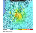
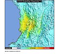
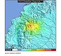
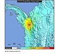
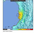
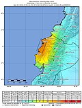
The most devastating earthquake for Colombia happened on August 15 and 16, 1868 off the coast of Ecuador, leading to approximately 70,000 fatalities. The strongest earthquake, with an estimated moment magnitude of 8.8 also happened offshore Ecuador in 1906. Other major earthquakes were the 1875 Cúcuta earthquake with around 10,000 deaths and the 1999 Armenia earthquake with an intensity of X. The deepest registered earthquake happened in the department of Amazonas in 1970 at an estimated depth of almost 645 kilometres (2,116,000 ft). The 1785 Viceroyalty of New Granada earthquake sparked the birth of journalism in Colombia, initiated by Manuel del Socorro Rodríguez, six years after the publication of the Aviso del Terremoto about the earthquake with its epicentre in La Calera, Cundinamarca.

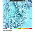
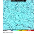
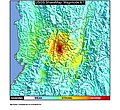
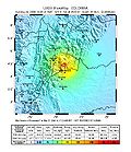
The main seismically active zone is the subduction zone of the Malpelo, formerly Nazca, Plate with strong earthquakes in 1906, 1947, 1958 and 1979. The most active onshore fault systems are the 674 kilometres (419 mi) Bucaramanga-Santa Marta Fault with earthquakes frequently occurring at the Bucaramanga Nest around Aratoca, Santander, the 697.4 kilometres (433.3 mi) Romeral Fault System in the Central Ranges (Popayán 1983 and Armenia 1999) and the 921.4 kilometres (572.5 mi) long Eastern Frontal Fault System in the Eastern Ranges. Other strong earthquakes are associated with the Murindó (Mw 7.2, 1992), Irlanda (Mw 6.8, 1994), Tucurá (Mw 6.7, 1952), Bahía Solano (Mw 6.5, 1970), and Mutatá Faults (Mw 6.0, 2016).

Major historical earthquakes

Note: out of many, [3] only earthquakes of Mw 6.0 and higher, deadly, important historical, [5] and unusual earthquakes are included in this list
Magnitudes - Mw Moment magnitude scale, ML Richter magnitude scale, Ms Surface wave magnitude, ? Unknown scale

YearDateTime
UTC−05
Place
bold is fault
Name Plate Depth
(km)
Fatalities Mag. MMI Tsunami MapNotes
1646April 302:00-03:00 Muzo-La Palma
Boyacá
Cundinamarca
1646 Muzo North Andes "dozens"IXNo
Colombia relief location map.jpg
Bullseye1.png
[6] [7]
1743October 18 Chingaza Páramo, Cundinamarca 1743 Chingaza North Andes 20"several"6.30 ± 0.35 B&W97IXNo
Colombia relief location map.jpg
Bullseye1.png
[6] [8]
[note 1]
1785July 1207:45 La Calera, Cundinamarca 1785 Viceroyalty of New Granada North Andes 20-3096.9 MsVIIINo
Colombia relief location map.jpg
Bullseye1.png
[10] [11]
1827November 1622:45 Timaná, Huila 1827 Timaná North Andes 102507.7 MsXNo
Colombia relief location map.jpg
Bullseye1.png
[12] [13]
1834January 2012:00 Sibundoy , Sibundoy, Putumayo 1834 Sibundoy North Andes 5807.0 ?IXNo
Colombia relief location map.jpg
Bullseye1.png
[6] [14]
[15]
1868August 15
August 16
14:30
01:30
Ecuador, Colombia 1868 Ecuador North Andes 2070,0006.3 and 6.7 MsXNo
Colombia relief location map.jpg
Bullseye1.png
[16]
1875May 1816:25 Cúcuta 1875 Cúcuta North Andes 2010,0007.5 ?IXNo
Colombia relief location map.jpg
Bullseye1.png
[17]
1906January 3115:36 Esmeraldas (Ecuador) 1906 Ecuador–Colombia Malpelo 20.01,000~8.8 Mw 8.6 MLVIIIYes
5 m (16 ft)
Colombia relief location map.jpg
Bullseye1.png
[18] [19]
1917August 3111:36 Acacías, Meta 1917 Sumapaz North Andes 4067.3 MsVIINo
Colombia relief location map.jpg
Bullseye1.png
[6] [20]
[21]
1936January 909:23 Túquerres 1936 Túquerres North Andes <302507.0 ?VIIINo
Colombia relief location map.jpg
Bullseye1.png
[22] [23]
1952February 1416:02 Tucurá , Pavarandocito, Antioquia 1952 Pavarandocito North Andes 446.75 MwNo
Colombia relief location map.jpg
Bullseye1.png
[24] [25]
1958January 1914:07 Ecuador, Colombia 1958 Ecuador–Colombia North Andes 40-601117.8 Mw 7.6 MLVIIIYes
1.5 m (4.9 ft)
Colombia relief location map.jpg
Bullseye1.png
[26]
1962July 3015:18 Aranzazu, Caldas 1962 Aranzazu North Andes 6950~6.8 MwVIIINo
Colombia relief location map.jpg
Bullseye1.png
[27] [28]
1967February 915:24 Algeciras , Algeciras, Huila 1967 Neiva North Andes 55.0987.2 Mw 6.8 MLVIIINo
1967 Neiva earthquake ShakeMap.jpg
[29] [30]
[31]
1967July 2905:24 Bucaramanga , Aratoca, Santander 1967 Aratoca North Andes 161.26.8 MwIVNo
1967 Aratoca earthquake ShakeMap.jpg
[32]
1970July 3117:08 Amazonas 1970 Colombia South American 644.818.0 Mw 7.7 MLIVNo
1970 Bahia Solano earthquake ShakeMap.jpg
[33]
1970September 2622:38 Bahía Solano , Bahía Solano, Chocó 1970 Bahía Solano North Andes 15.06.5 MwVII
1970 Choco earthquake ShakeMap.jpg
[34] [35]
1975January 2421:08 Chocó 1975 Chocó Panama 36.06.5 MsVII
1975 Choco earthquake ShakeMap.jpg
[36]
1979November 2318:40 El Cairo 1979 El Cairo North Andes 108.0447.2 Mw 6.7 MLVIINo
1979 El Cairo earthquake ShakeMap.jpg
[37]
1979December 1207:59 Tumaco 1979 Tumaco North Andes 336008.1 MsIXYes
5 m (16 ft)
1979 Tumaco earthquake ShakeMap.jpg
[38]
1983March 3108:15 Rosas-Julumito , Popayán 1983 Popayán North Andes 12.03005.5 MLVIIINo
Colombia relief location map.jpg
Bullseye1.png
[39] [40]
1987March 5
March 6
20:54, 23:10
03:14
Ecuador, Colombia 1987 Ecuador-Colombia North Andes 8.5
14.1
1,000
4,000+ missing
6.0-7.2 MwVIINo
1987 Ecuador-Colombia earthquakes ShakeMap.jpg
[41] [42]
[43]
1991November 1917:28 Chocó 1991 Chocó North Andes 21.37.2 MwIX
1991 Choco earthquake ShakeMap.jpg
[44]
1992October 1810:11 Murindó , Murindó, Antioquia 1992 Murindó North Andes 10.07.2 MwVIIINo
1992 Murindo earthquake ShakeMap.jpg
[45] [46]
1994June 620:47 Irlanda , Páez 1994 Páez River North Andes 121,1006.8 MwVIINo
1994 Paez River earthquake ShakeMap.jpg
[47] [48]
1995January 1910:05 Guaicáramo , Tauramena 1995 Tauramena North Andes 17.366.0 ML 6.5 MwVIINo
1995 Tauramena earthquake ShakeMap.jpg
[49] [50]
1995February 813:40 Cali 1995 Cali North Andes 73.5356.4 MwVNo
1995 Cali earthquake ShakeMap.jpg
[51]
1996November 412:24 Chocó 1996 Colombia-Panama Panama 14.06.3 MwVIIINo
1996 Colombia-Panama earthquake ShakeMap.jpg
[52]
1999January 2518:19 Córdoba-Navarco , Armenia 1999 Armenia North Andes 17.01,9006.1 MwXNo
1999 Armenia, Colombia earthquake ShakeMap.jpg
[53] [54]
2004November 1504:06 Bajo Baudó, Pacific Ocean, Chocó 2004 Bajo Baudó North Andes 15.006.7 ML 7.2 MwVIII
2004 Bajo Baudo earthquake ShakeMap.jpg
[55]
2007September 920:49 Gorgona Island 2007 Gorgona Island North Andes 15.05 injured / 34 homes damaged6.8 MwVII
2007 Gorgona Island earthquake ShakeMap.jpg
[56]
2008May 2419:20 El Calvario 2008 El Calvario North Andes 35115.9 MwVIINo
2008-Colombia earthquake intensity-map.jpg
[57]
2012September 3011:31 La Vega 2012 La Vega North Andes 17007.3 MwVIINo
2012 La Vega earthquake ShakeMap.jpg
[58]
2013February 909:16 Yacuanquer, Nariño 2013 Nariño North Andes 14506.9 MwVINo
2013 Narino earthquake ShakeMap.jpg
[59] [60]
2013August 1310:43 Chocó 2013 Chocó Coiba 12.006.7 MwV
2013 Choco earthquake ShakeMap.jpg
[61]
2015March 1015:55 Bucaramanga , Aratoca, Santander 2015 Santander North Andes 15506.2 MwVINo
2015 Northern Colombia earthquake shakemap.jpg
[62] [63]
2016April 1618:58 Ecuador, Colombia 2016 Ecuador-Colombia North Andes 20.66767.8 MwIXNo
Shakemap Ecuador April 2016.jpg
[64]
2016September 1320:58 Mutatá , Mutatá, Antioquia 2016 Mutatá North Andes 18.006.0 MwVINo
2016 Mutata earthquake ShakeMap.jpg
[65]
2018June 1204:35 Pasto, Nariño 2018 Pasto North Andes 10.024.9 MwVINo [66] [67]
2021March 117:57 Antioquia Department 2021 Antioquia North Andes 10.035.1 MwVINo [68]
2023August 1712:04 Meta Department 2023 Central Colombia North Andes 10.026.1 MwVIINo

See also

Notes and references

Notes

  1. Bakun & Wentworth 1997 scale [9]

Related Research Articles

<span class="mw-page-title-main">Lists of earthquakes</span>

Earthquakes are caused by movements within the Earth's crust and uppermost mantle. They range from events too weak to be detectable except by sensitive instrumentation, to sudden and violent events lasting many minutes which have caused some of the greatest disasters in human history. Below, earthquakes are listed by period, region or country, year, magnitude, cost, fatalities and number of scientific studies.

The 1982 El Salvador earthquake occurred southeast of San Salvador on 19 June at 00:21 local time. This undersea earthquake struck offshore in the Pacific Ocean and had a surface wave magnitude of 7.3 and a maximum Mercalli intensity of VII. Occurring adjacent to a subduction zone at the Middle America Trench, this normal-slip shock left at least 16 and as many as 43 people dead, and many injured, and also inflicted $5 million in damage.

<span class="mw-page-title-main">Manuel del Socorro Rodríguez</span> Cuban journalist

Manuel del Socorro Rodríguez was a Cuban journalist. He is considered to be the founder of journalism in Colombia. Five years before his arrival in the Viceroyalty of New Granada, the 1785 Viceroyalty of New Granada earthquake had happened, described in the Aviso del Terremoto and published the day of the earthquake. This sparked the birth of journalism in Colombia, when Del Socorro started to report in 1791.

The 1953 Tumbes earthquake occurred on December 12 at 12:31:29 local time near the border between Peru and Ecuador. The shock had a moment magnitude of 7.5, a maximum Mercalli Intensity of VIII (Severe), and occurred in the northwestern offshore area of Tumbes, Peru.

<span class="mw-page-title-main">1967 Neiva earthquake</span> Earthquake in Colombia

The 1967 Neiva earthquake occurred at 10:24 local time (UTC-05) on February 9 in Colombia. The epicentre of the earthquake was located in San Vicente del Caguán in the department of Caquetá. The earthquake, associated with the Algeciras Fault, part of the megaregional Eastern Frontal Fault System, had a moment magnitude of 7.0 and an intensity of VIII and was felt in northwestern South America from Caracas to Iquitos and Buenaventura to Mitú. In the following months, 350 aftershocks were registered in the area. The earthquake produced 98 fatalities and approximately 600,000 USD in damage.

The Romeral Fault System is a megaregional system of major parallel and anastomosing faults in the Central Ranges of the Colombian Andes and the Cauca, Amagá, and Sinú-San Jacinto Basins. The system spans across ten departments of Colombia, from northeast to south Bolívar, Sucre, Córdoba, Antioquia, Caldas, Risaralda, Quindío, Valle del Cauca, Cauca and Nariño. The fault zone extends into Ecuador where it is known as the Peltetec Fault System. The in detail described part of the Romeral Fault System south of Córdoba has a total length of 697.4 kilometres (433.3 mi) with a cumulative length of 1,787.9 kilometres (1,110.9 mi) and runs along an average north to south strike of 017.6 ± 16, cross-cutting the central-western portion of Colombia.

The Córdoba-Navarco Fault is a sinistral strike-slip fault in the department of Quindío in west-central Colombia. The fault has a total length of 21.2 kilometres (13.2 mi) and runs along an average north-northeast to south-southwest strike of 018.5 ± 4 in the Central Ranges of the Colombian Andes.

<span class="mw-page-title-main">Bahía Solano Fault</span>

The Bahía Solano Fault, Utría Fault or Utría-Bahía Solano Fault is a westward dipping thrust fault in the department of Chocó on the Pacific Coast of Colombia. The fault has a total length of 290.6 kilometres (180.6 mi) and runs along an average north–south strike of 347 ± 13 from the Panama-Colombia border to Bajo Baudó. The fault is partly offshore in the bays of Solano and Utría and crosses the Chocó Basin and the coastal Serranía del Baudó. Movement of the fault produced the Mw  6.5 1970 Bahía Solano earthquake.

The Cimitarra Fault is a sinistral oblique thrust fault in the departments of Antioquia, Bolívar and Santander in central Colombia. The fault has a total length of 136.5 kilometres (84.8 mi) and runs along an average northeast to southwest strike of 323 ± 3 in the Middle Magdalena Valley and Central Ranges of the Colombian Andes.

The 1942 Ecuador earthquake or the Guayaquil earthquake occurred on 13 May at 9:06 or 9:13 pm local time with a moment magnitude of Mw  7.9. The temblor struck the coastal (Esmeraldas) region of Manabí Province, Ecuador. It caused damage mainly to cities including Guayaquil, Portoviejo and Guaranda. More than 300 people were killed and the total cost of damage was about US$2.5 million. Ecuador's largest city Guayaquil was the most affected despite the significant distantce from the epicenter. Many reinforced concrete structures in a particular area in the city were completely destroyed, contributing to fatalities.

<span class="mw-page-title-main">2021 Northern Peru earthquake</span> 2021 earthquake in Peru

A major earthquake struck northern Peru on November 28, 2021, 5:52 a.m. local time with a magnitude of 7.5 on the moment magnitude scale between the Amazonas and Loreto departments of Peru. A maximum Modified Mercalli intensity (MMI) of VII was reported in the town of Santa Maria de Nieva according to the Geological Institute of Peru.

<span class="mw-page-title-main">2022 Michoacán earthquake</span> 2022 earthquake in Mexico

On 19 September 2022, a moment magnitude 7.6-7.7 earthquake struck between the Mexican states of Michoacán and Colima at 13:05:06 local time. The earthquake had a depth of 26.9 km (16.7 mi), resulting in a maximum intensity of VIII (Severe) on the Modified Mercalli intensity scale. The USGS reported the epicentre was 35 km (22 mi) southwest of the town of Aquila. Two people were killed and at least 35 others were injured across several states. A magnitude 6.8 aftershock struck on 22 September, causing three more deaths.

References

  1. Ramírez, 1975, p.63
  2. Ramírez, 1975, p.65
  3. 1 2 Ramírez, 1975, p.217
  4. Espinosa Baquero, 2001, p.273
  5. Various Authors, 2014, p.7
  6. 1 2 3 4 Various Authors, 2014, p.8
  7. Espinosa Baquero, 1999, p.211
  8. Salcedo & Gómez, 2013
  9. Bakun & Wentworth, 1997
  10. Gómez Capera et al., 2014, p.214
  11. Sarabia Gómez et al., 2010a, p.154
  12. Various Authors, 2008a, p.30
  13. NGDC. "Comments for the 1827 Earthquake". NGDC . Retrieved 2017-09-18.
  14. Paris et al., 2000, p.46
  15. NGDC. "Comments for the 1834 Earthquake". NGDC . Retrieved 2017-09-18.
  16. Giesecke et al., 2004
  17. NGDC. "Comments for the 1875 Earthquake". NGDC . Retrieved 2017-09-18.
  18. Mendoza & Dewey, 1984
  19. USGS. "M 8.8 - near the coast of Ecuador". United States Geological Survey . Retrieved 2017-09-18.
  20. Sarabia Gómez et al., 2010a, p.160
  21. NGDC. "Comments for the 1917 Earthquake". NGDC . Retrieved 2017-09-18.
  22. Sarabia Gómez et al., 2010b
  23. NGDC. "Comments for the 1936 Earthquake". NGDC . Retrieved 2017-09-18.
  24. Ramírez, 1975, p.223
  25. Paris et al., 2000, p.13
  26. NGDC. "Comments for the 1958 Earthquake". NGDC . Retrieved 2017-09-18.
  27. Various Authors, 2014, p.9
  28. Various Authors, 2008b, pp.83–94
  29. NGDC. "Comments for the 1967 Earthquake". NGDC . Retrieved 2017-09-18.
  30. USGS. "M 7.0 - Colombia". United States Geological Survey . Retrieved 2017-09-18.
  31. Paris et al., 2000, p.43
  32. USGS. "M 6.8 - northern Colombia". United States Geological Survey . Retrieved 2017-09-18.
  33. USGS. "M 8.0 - Colombia". United States Geological Survey . Retrieved 2017-09-18.
  34. Paris et al., 2000, p.16
  35. USGS. "M 6.5 - near the west coast of Colombia". United States Geological Survey . Retrieved 2017-09-18.
  36. USGS. "M 6.5 - Panama-Colombia border region". United States Geological Survey . Retrieved 2017-09-18.
  37. USGS. "M 6.4 - Colombia". United States Geological Survey . Retrieved 2017-09-18.
  38. NGDC. "Comments for the 1979 Earthquake". NGDC . Retrieved 2017-09-18.
  39. Marín Arias et al., 2006, p.94
  40. Paris et al., 2000, p.24
  41. USGS. "M 6.4 - Colombia-Ecuador border region". United States Geological Survey . Retrieved 2017-09-18.
  42. USGS. "M 7.2 - Colombia-Ecuador border region". United States Geological Survey . Retrieved 2017-09-18.
  43. USGS. "M 6.0 - Colombia-Ecuador border region". United States Geological Survey . Retrieved 2017-09-18.
  44. USGS. "M 7.2 - near the west coast of Colombia". United States Geological Survey . Retrieved 2017-09-18.
  45. Paris et al., 2000, p.15
  46. USGS. "M 7.2 - northern Colombia". United States Geological Survey . Retrieved 2017-09-18.
  47. Paris et al., 2000, p.58
  48. NGDC. "Comments for the 1994 Earthquake". NGDC . Retrieved 2017-09-18.
  49. USGS. "M 6.5 - Colombia". United States Geological Survey . Retrieved 2017-09-18.
  50. Paris et al., 2000, p.38
  51. USGS. "M 6.4 - Colombia". United States Geological Survey . Retrieved 2017-09-18.
  52. USGS. "M 6.3 - Panama-Colombia border region". United States Geological Survey . Retrieved 2017-09-18.
  53. USGS. "M 6.1 - Colombia". United States Geological Survey . Retrieved 2017-09-18.
  54. Paris et al., 2000, p.25
  55. USGS. "M 7.2 - near the west coast of Colombia". United States Geological Survey . Retrieved 2017-09-18.
  56. USGS. "M 6.8 - near the west coast of Colombia". United States Geological Survey . Retrieved 2017-09-18.
  57. NGDC. "Comments for the 2008 Earthquake". NGDC . Retrieved 2017-09-18.
  58. USGS. "M 7.3 - Colombia". United States Geological Survey . Retrieved 2017-09-18.
  59. EMSC. "M 7.0 - Colombia - 2013-02-09 14:16:07 UTC". EMSC . Retrieved 2017-09-18.
  60. USGS. "M 6.9 - 2km N of Yacuanquer, Colombia". United States Geological Survey . Retrieved 2017-09-18.
  61. USGS. "M 6.7 - 101km WSW of Mutis, Colombia". United States Geological Survey . Retrieved 2017-09-18.
  62. EMSC. "M 6.2 - Northern Colombia - 2015-03-10 20:55:46 UTC". EMSC . Retrieved 2017-09-18.
  63. USGS. "M 6.2 - 9km NNE of Aratoca, Colombia". United States Geological Survey . Retrieved 2017-09-18.
  64. USGS. "M 7.8 - 27km SSE of Muisne, Ecuador". United States Geological Survey . Retrieved 2017-09-18.
  65. USGS. "M 6.0 - 32km ENE of Mutata, Colombia". United States Geological Survey . Retrieved 2017-09-18.
  66. USGS. "M 4.9 - 16km ESE of Tangua, Colombia". USGS . Retrieved 2018-06-12.
  67. "Tres sismos en Pasto deja dos muertos y varios heridos". 90minutos.co (in Spanish). 2018-06-12. Retrieved 2018-06-12.
  68. "M 5.1 - 20 km SW of Urrao, Colombia". earthquake.usgs.gov. Retrieved March 2, 2021.

Bibliography

Further reading