Tauramena

Last updated
Tauramena
Municipality and town
Flag of Tauramena, Casanare.svg
Escudo de Tauramena.svg
Colombia - Casanare - Tauramena.svg
Location of the municipality and town of Tauramena in the Casanare Department of Colombia.
CountryFlag of Colombia.svg  Colombia
Department Casanare Department
Population
 (Census 2018 [1] )
  Total21,709
Time zone UTC-5 (Colombia Standard Time)

Tauramena is a town and municipality in the Department of Casanare, Colombia.

Climate

Tauramena has a tropical monsoon climate (Köppen Am) with moderate to little rainfall from December to March and heavy to very heavy rainfall from April to November.

Climate data for Tauramena, elevation 460 m (1,510 ft), (1981–2010)
MonthJanFebMarAprMayJunJulAugSepOctNovDecYear
Mean daily maximum °C (°F)31.4
(88.5)
32.0
(89.6)
31.7
(89.1)
30.2
(86.4)
29.6
(85.3)
28.9
(84.0)
28.7
(83.7)
29.2
(84.6)
29.8
(85.6)
30.2
(86.4)
30.1
(86.2)
30.4
(86.7)
30.1
(86.2)
Daily mean °C (°F)26.2
(79.2)
26.5
(79.7)
26.3
(79.3)
25.5
(77.9)
25.2
(77.4)
24.8
(76.6)
24.4
(75.9)
24.9
(76.8)
25.3
(77.5)
25.5
(77.9)
25.6
(78.1)
25.9
(78.6)
25.5
(77.9)
Mean daily minimum °C (°F)20.7
(69.3)
21.3
(70.3)
21.8
(71.2)
21.4
(70.5)
21.0
(69.8)
20.8
(69.4)
20.5
(68.9)
20.6
(69.1)
20.6
(69.1)
20.8
(69.4)
20.9
(69.6)
20.8
(69.4)
20.9
(69.6)
Average precipitation mm (inches)15.7
(0.62)
52.8
(2.08)
129.2
(5.09)
343.2
(13.51)
433.8
(17.08)
444.8
(17.51)
386.0
(15.20)
331.3
(13.04)
311.1
(12.25)
306.3
(12.06)
190.7
(7.51)
57.3
(2.26)
3,002.3
(118.20)
Average precipitation days35917212122191615136161
Average relative humidity (%)77757381838584848281828181
Source: Instituto de Hidrologia Meteorologia y Estudios Ambientales [2]

Related Research Articles

<span class="mw-page-title-main">Cañasgordas</span> Municipality and town in Antioquia Department, Colombia

Cañasgordas is a town and municipality in Antioquia Department, Colombia. The population was 13,595 at the 2018 census.

<span class="mw-page-title-main">Chigorodó</span> Municipality and town in Antioquia Department, Colombia

Chigorodó is a town and municipality in Antioquia Department, Colombia. It is part of the Urabá Antioquia sub-region.

<span class="mw-page-title-main">Valdivia, Antioquia</span> Municipality and town in Antioquia Department, Colombia

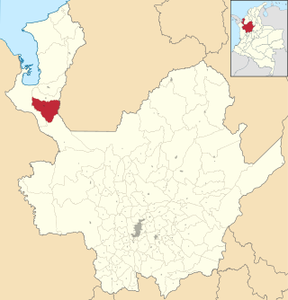
Valdivia is a town and municipality in Antioquia Department, Colombia. Part of the subregion of Northern Antioquia, its population was 11,511 at the 2018 census.

<span class="mw-page-title-main">San Juan de Urabá</span> Municipality and town in Antioquia Department, Colombia

San Juan de Urabá is a town and municipality in the Colombian department of Antioquia. It is part of the Urabá Antioquia sub-region.

<span class="mw-page-title-main">San Pedro de Urabá</span> Municipality and town in Antioquia Department, Colombia

San Pedro de Urabá is a municipality in Antioquia Department, Colombia. It is part of the Urabá Antioquia sub-region.

<span class="mw-page-title-main">Otanche</span> Municipality and town in Boyacá Department, Colombia

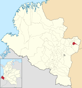
Otanche is a town and municipality in Boyacá Department, Colombia, part of the subregion of the Western Boyacá Province.

<span class="mw-page-title-main">Sutatenza</span> Municipality and town in Boyacá Department, Colombia

Sutatenza is a town and municipality in the Eastern Boyacá Province of the department of Boyacá, Colombia. It is located 125 kilometres (78 mi) from the Colombian capital Bogotá and 118 kilometres (73 mi) from the department capital Tunja. Sutatenza borders Somondoco, Guateque, Tenza and Garagoa.

<span class="mw-page-title-main">Barranco de Loba</span> Municipality and town in Bolívar Department, Colombia

Barranco de Loba is a town and municipality located in the Bolívar Department, northern Colombia.

<span class="mw-page-title-main">Montecristo, Bolívar</span> Municipality and town in Bolívar Department, Colombia

Montecristo is a town and municipality located in the Bolívar Department, northern Colombia.

<span class="mw-page-title-main">Toledo, Norte de Santander</span> Municipality and town in Norte de Santander Department, Colombia

Toledo is a Colombian municipality and town located in the department of North Santander. It is on the border with Boyacá Department and has natural gas development in the township of Gibraltar. In August 2011 the Gibraltar to Bucaramanga gas pipeline was completed.

<span class="mw-page-title-main">Bolívar, Santander</span> Municipality and town in Santander Department, Colombia

Bolívar is a town and municipality in the Santander Department in northeastern Colombia.

<span class="mw-page-title-main">Medio Baudó</span> Municipality and town in Chocó Department, Colombia

Medio Baudó is a municipality and town in the Chocó Department, Colombia.

<span class="mw-page-title-main">Tadó</span> Municipality and town in Chocó Department, Colombia

Tadó is a municipality and town in the Chocó Department, Colombia.

<span class="mw-page-title-main">Unguía</span> Municipality and town in Chocó Department, Colombia

Unguía is a municipality and town in the far north of the Chocó Department, Colombia.

<span class="mw-page-title-main">Aguazul</span> Municipality and town in Orinoquía Region, Colombia

Aguazul is a town and municipality in the Department of Casanare, Colombia. Its economy is dependent on oil, mainly Cupiagua and Cusiana fields. Other important products of its economy are livestock and rice. As of 2004, Leonel Torres has been mayor of the city.

<span class="mw-page-title-main">Pajarito, Boyacá</span> Municipality and town in Boyacá Department, Colombia

Pajarito is a town and municipality in the La Libertad Province, part of the Colombian department of Boyacá. The municipality, situated in the southeast of the department borders Labranzagrande and Aquitania of the department of Boyacá and Yopal, Recetor and Aguazul of the department of Casanare. The urban centre is located at a distance of 147 kilometres (91 mi) from the department capital Tunja at an altitude of 800 metres (2,600 ft) in a tight valley, not allowing much expansion of the urban area. The centre is experiencing periodic landslides.

<span class="mw-page-title-main">Campohermoso</span> Municipality and town in Boyacá Department, Colombia

Campohermoso is a town and municipality in the Colombian Department of Boyacá, part of the subregion of the Lengupá Province.

<span class="mw-page-title-main">Arcabuco</span> Municipality and town in Boyacá Department, Colombia

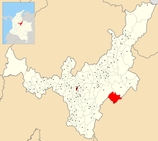
Arcabuco is a town and municipality in the Ricaurte Province, part of the Colombian Department of Boyacá. Arcabuco is situated on the Altiplano Cundiboyacense with the urban centre at an altitude of 2,739 metres (8,986 ft). The municipality borders Moniquirá and Gámbita in the north, Villa de Leyva and Chíquiza in the south, Cómbita in the east and Gachantivá and Villa de Leyva in the west. The department capital Tunja is 34 kilometres (21 mi) to the south.

<span class="mw-page-title-main">San Bernardo, Nariño</span> Municipality and town in Nariño Department, Colombia

San Bernardo is a town and municipality in the Nariño Department, Colombia.

<span class="mw-page-title-main">Aldeanueva de Barbarroya</span> Place in Castile-La Mancha, Spain

Aldeanueva de Barbarroya is a municipality located in the province of Toledo, Castile-La Mancha, Spain. According to the 2018 census (INE), the municipality has a population of 542 inhabitants.

References

  1. "Censo Nacional de Población y Vivienda 2018" (in Spanish). Retrieved 23 April 2020.
  2. "Promedios Climatológicos 1981–2010" (in Spanish). Instituto de Hidrologia Meteorologia y Estudios Ambientales. Archived from the original on 15 August 2016. Retrieved 17 June 2024.

5°01′N72°45′W / 5.017°N 72.750°W / 5.017; -72.750