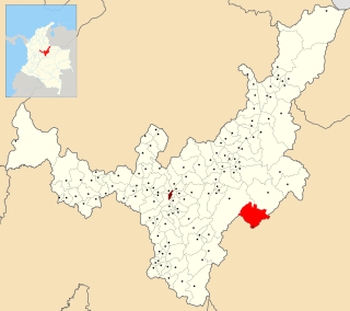
Boyacá is one of the thirty-two departments of Colombia, and the remnant of Boyacá State, one of the original nine states of the "United States of Colombia".

Arauca is a department of Eastern Colombia located in the extreme north of the Orinoco Basin of Colombia, bordering Venezuela. The southern boundary of Arauca is formed by the Casanare and Meta Rivers, separating Arauca from the departments of Casanare and Vichada. To the west, Arauca borders the department of Boyacá. The Caño Limón oil fields located within Arauca account for almost a third of the Colombian oil output. Its capital is the town of Arauca.

Casanare is a department located in the central eastern of Colombia. It is famous for its oil and natural gas production as well as its livestock and extensive plains. It is also the tenth largest department with an area of 44,490 km2, similar to that of Denmark, but also the seventh least densely populated.

Yopal is a municipality and capital city of the department of Casanare in Colombia. And the second most populated and important city in the Orinoquía region after Villavicencio.

Iza is a town and municipality in Boyacá Department, Colombia. Iza is located near the Tota Lake and part of the Sugamuxi Province, a subregion of Boyacá. Iza is located in the Eastern Ranges of the Colombian Andes on the Altiplano Cundiboyacense at a distance of 13 kilometres (8.1 mi) from Sogamoso and 90 kilometres (56 mi) from the department capital Tunja. The municipality borders Firavitoba and Sogamoso in the north, Sogamoso and Cuítiva in the east, in the west Pesca and Firavitoba, and in the south Cuítiva.

Muzo is a town and municipality in the Western Boyacá Province, part of the department of Boyacá, Colombia. It is widely known as the world capital of emeralds for the mines containing the world's highest quality gems of this type. Muzo is situated at a distance of 178 kilometres (111 mi) from the departmental capital Tunja and 118 kilometres (73 mi) from the capital of the Western Boyacá Province, Chiquinquirá. The urban centre is at an altitude of 815 metres (2,674 ft) above sea level. Muzo borders Otanche and San Pablo de Borbur in the north, Maripí and Coper in the east, Quípama in the west and the department of Cundinamarca in the south.

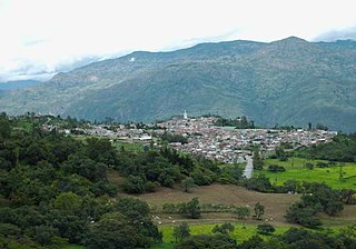
Boyacá is a town and municipality in the Márquez Province, part of the department of Boyacá, Colombia. It is located approximately 15 kilometres (9.3 mi) from the city of Tunja, the capital of the department. Boyacá limits Tunja and Soracá in the north, Jenesano in the south, Nuevo Colón and Ramiriquí in the west and Ventaquemada in the east.
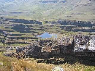
Pisba is a town and municipality in Boyacá Department, Colombia, part of the subregion of La Libertad Province. Pisba is situated in the Eastern Ranges of the Colombian Andes at altitudes between 2,400 metres (7,900 ft) and 3,500 metres (11,500 ft). Distance to Sogamoso is 128 kilometres (80 mi) and to Tunja 176 kilometres (109 mi). The municipality borders Paya in the east, Labranzagrande in the south and Mongua in the northwest. The Casanare municipality Támara borders Pisba in the north.
Soatá is a town and municipality in Boyacá Department, Colombia. Soatá is located on the western slopes of the Cordillera Oriental mountain range, at the northeast end of the Department of Boyacá. It is the capital of the Northern Boyacá Province. Soatá borders Boavita in the east, Tipacoque in the north, Susacón in the south and in the west it borders the municipality Onzaga of the department of Santander.

Recetor is a Colombian municipality in the Department of Casanare. Its jurisdiction has an area of 182 square kilometres or 70 square miles and a population of 4072. It is located on the eastern slope of the Colombian Andes, with an altitude of 800 metres or 2,620 feet. It has an average temperature of 22 °C or 71.6 °F.

Támara is a town and municipality in the Department of Casanare, Colombia. The urban centre is located at an altitude of 1,156 metres (3,793 ft) at a distance of 95 kilometres (59 mi) from the department capital Yopal. It borders in the north Sacama, in the east Pore and Paz de Ariporo, in the west Socotá of the department of Boyacá and in the south Nunchia and Paya, Boyacá.

Oicatá is a town and municipality in the Central Boyacá Province, Department of Boyacá, Colombia. The urban centre is situated on the Altiplano Cundiboyacense at an altitude of 2,815 metres (9,236 ft) and a distance of 153 kilometres (95 mi) from the national capital Bogotá and 15 kilometres (9.3 mi) from the department capital Tunja. It borders Cómbita and Tuta in the north, Chivatá and Tunja in the south, Chivatá in the east and in the west Cómbita and Tunja.
Pajarito is a town and municipality in the La Libertad Province, part of the Colombian department of Boyacá. The municipality, situated in the southeast of the department borders Labranzagrande and Aquitania of the department of Boyacá and Yopal, Recetor and Aguazul of the department of Casanare. The urban centre is located at a distance of 147 kilometres (91 mi) from the department capital Tunja at an altitude of 800 metres (2,600 ft) in a tight valley, not allowing much expansion of the urban area. The centre is experiencing periodic landslides.

Paya is a town and municipality in the La Libertad Province, part of the Colombian department of Boyacá. Paya limits Pisba, Labranzagrande of Boyacá and Támara, Nunchía and Yopal (Casanare).

Firavitoba is a town and municipality in Sugamuxi Province, a subregion of the department of Boyacá in Colombia.

Socotá is a town and municipality in the Valderrama Province, part of the Colombian department of Boyacá. The municipality is situated in the Eastern Ranges of the Colombian Andes. The urban centre is at an altitude of 2,443 metres (8,015 ft) at a distance of 134 kilometres (83 mi) from the department capital Tunja. It borders Jericó and Sativanorte in the north, Pisba and Mongua in the south, Chita and Támara, Casanare in the east and Sativasur, Tasco, Socha and Gámeza in the west.

Geology of Colombia refers to the geological composition of the Republic of Colombia that determines its geography. Most of the emerged territory of Colombia covers vast areas within the South American plate, whereas much submerged territory lies within the Caribbean plate and the Nazca plate.
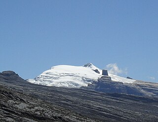
The Sierra Nevada del Cocuy Chita or Guican National Natural Park (or Sierra Nevada de Chita or Sierra Nevada de Güicán, Spanish: Parque Natural Sierra Nevada del Cocuy Chita o Guican is a national park and a series of highlands and glaciated peaks located within the Cordillera Oriental mountain range in the Andes Mountains of Colombia, at its easternmost point. It also corresponds to the highest range of the Eastern Cordillera and holds the biggest glacial mass in South America, north of the Equator. Since 1977, this region is protected within a National Natural Park because of its fragile páramos, extraordinary bio-diversity and endemism, and its function as a corridor for migratory species under conditions of climate change. Among the Sierra’s natural attractions are the remaining 18 ice-covered peaks, glacial lakes and waterfalls.
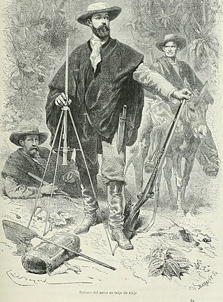
A ruana is a poncho-style outer garment native to the Colombian and Venezuelan Andes. In Colombia, the ruana is the characteristic and traditional garment of the department of Boyacá, initially made by indigenous and mestizo people, although it is also made in the departments of Cundinamarca, Antioquia, Nariño, Bogotá, Santander (Colombia), Norte de Santander and Caldas. In Venezuela it is widely used and made in the Andean states of Táchira, Mérida and Trujillo, used since the colonial times by all Venezuelan inhabitants, currently only in the Andean region its traditional use is maintained.

The Eastern Frontal Fault System is a megaregional system of oblique and thrust faults cross-cutting Colombia from Ecuador in the south to Venezuela in the north. The system from south to north covers ten out of 32 departments of Colombia; Nariño, Putumayo, Cauca, Huila, Caquetá, Cundinamarca, Meta, Boyacá, Casanare and Arauca. The Eastern Frontal Fault System underlies and affects the capitals of Putumayo, Mocoa, Caquetá, Florencia, Meta, Villavicencio and Casanare, Yopal. The fault system has a total length of 921.4 kilometres (572.5 mi) with a cumulative length of the faults of 1,821.8 kilometres (1,132.0 mi) and runs along an average northeast to southwest strike of 042.1 ± 19 bordering and crossing the Eastern Ranges of the Colombian Andes. The fault system forms the boundary between the North Andes microplate and the South American Plate.