2023 central Colombia earthquakes

Last updated
2023 central Colombia earthquakes
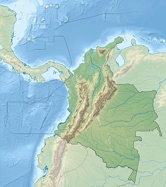
Colombia relief location map.jpg
Bullseye1.png
2023 central Colombia earthquakes (Colombia)
Cundinamarca Topographic 2.png
Bullseye1.png
2023 central Colombia earthquakes (Cundinamarca Department)
Meta Topographic 2.png
Bullseye1.png
2023 central Colombia earthquakes (Meta Department)
UTC  time2023-08-17 17:04:59
 2023-08-17 17:17:18
ISC  event 626686825
  626686828
USGS-ANSS ComCat
  ComCat
Local date17 August 2023
Local time12:04 (UTC-5)
 12:17 (UTC-5)
Magnitude6.1 Mw
 5.6 Mw
Depth10 km (6 mi)
Epicenter 4°21′N73°35′W / 4.35°N 73.59°W / 4.35; -73.59
Areas affected Colombia, Venezuela
Max. intensity MMI VIII (Severe)
Aftershocks64 (as of 18 August) [1]
Largest is Mw5.0 [2]
Casualties2 dead, 50 injured [1] [3]

A earthquake with a moment magnitude of 6.1 and its aftershocks affected the El Calvario Capital-Cordillera subregion ( Villavicencio, Restrepo, Cumaral, San Juanito ) and Medina province ( Medina, Paratebueno ), on 17 August 2023. [4] [5]

Contents

Tectonic setting

Subduction of the Nazca plate beneath the North Andes plate (part of the South American plate) occasionally produces moderately large to great earthquakes along the coast of Colombia. The megathrust fault forms the northern part of the Peru–Chile Trench, which has been the source of very large earthquakes including the 1906 Ecuador–Colombia earthquake; the magnitude 8.8 tremor is the biggest in the region and the sixth largest earthquake to be instrumentally recorded.

The North Andes plate moves northeastwards relative to the South American plate at a rate of 8.6 mm per year. This motion is partitioned into motion parallel to the plate boundary (right lateral strike-slip) of 8.1 mm per year and 4.3 mm per year perpendicular to the boundary in the form of shortening. The boundary is formed by the Eastern Frontal Fault System, which consists of both thrust faults and oblique-slip faults that together take up this displacement. [6] This boundary has been associated with many damaging historical earthquakes, such as the 1967 Neiva and the 2008 El Calvario earthquakes. [7] [8]

Earthquake

The location of the first earthquake was in El Calvario, in the department of Meta, 70 km (43 mi) southeast of the country's capital, Bogotá. The depth of the earthquakes were about 10 km (6.2 mi) beneath the surface. [4]

Tremors from the earthquakes were strongly felt in Bogotá, with a Modified Mercalli intensity of V (Moderate) reported there. [4]

Impact

Damage and casualties

At least five of Colombia's departments were affected by the earthquake. [1] In total, at least 20 houses collapsed and 252 others were damaged across the country; damage was reported as far away as Armenia, in Quindío Department. [9] Two people were killed as a result of the earthquake; a woman in Bogotá after jumping from a building and a man after an earthquake-related incident in a mine near Sativanorte. [10] [11] Both were Venezuelan nationals. [12] [13] A total of six buildings collapsed and 154 others were damaged in Meta, [14] [15] while 44 buildings were affected in Cundinamarca, including one that collapsed. [16] Several buildings and a church were also damaged in Boyacá. [17]

In Gachalá, at least 88 houses were affected, including 12 that collapsed; a church and a fire station were also affected. Two people were injured there. [18] [3] The facade of a building collapsed in Guayabetal. [16] Some houses were destroyed and four others partially collapsed in El Calvario, where several students were hospitalized. [18] In Cáqueza, one person was injured and 26 students were hospitalized due to shock, and three houses, the municipal building and a market were damaged. [3] In Sibate, the city hall was damaged and 15 students were hospitalized due to panic. [3] One person in Soacha was injured by a wall collapse and another was hospitalized due to panic. [3] In Sativanorte, another mining incident caused by the earthquake caused one injury. [11] Four minors were also injured, three of them in Meta and another in Boyacá. [1]

Sixty-three buildings and the courthouse in Villavicencio was damaged and windows were broken in several buildings in the city. [15] [19] In Bogotá, at least 178 buildings were damaged. [10] Among them was one of the buildings housing the Congress of Colombia, where parts of the roof fell. [16] In Zulia, Venezuela, a church collapsed. [20]

Estimations of losses

The United States Geological Survey's PAGER service estimates included an orange-alert level, reporting there was a 93% chance that the earthquake could cause damage between US$1 million and US$10 billion. It also said the earthquake had a 76% of causing between one and 1,000 fatalities. [4]

For the second earthquake, the USGS issued an orange-alert and estimated an 82% chance that it would cause between one and 1,000 fatalities, as well as a 95% of it causing between US$1 million and US$10 billion worth of damage. [5]
See also

Related Research Articles

<span class="mw-page-title-main">Quetame</span> Municipality and town in Cundinamarca, Colombia

Quetame is a municipality and town of Colombia in the Eastern Province, part of the department of Cundinamarca. The urban centre of Quetame is located at 62 kilometres (39 mi) from the capital Bogotá at an altitude of 1,496 metres (4,908 ft). The municipality borders Fómeque in the north, Fosca and Cáqueza in the west, the department of Meta in the east and in the south with Guayabetal.

<span class="mw-page-title-main">2008 El Calvario earthquake</span> Earthquake in Colombia

The 2008 El Calvario earthquake occurred in central Colombia on 24 May and measured 5.9 on the moment magnitude scale. The earthquake occurred at 2:20:43 p.m. at the epicenter. The depth was 35 km; it was superficial according to an Ingeominas report. The epicenter was located 35 km from Villavicencio and 50 km from Bogotá. There were 11 confirmed fatalities and 4,181 injured, mostly in the towns of Puente Quetame, Fosca, Fomeque and Guayabetal in Cundinamarca, and in El Calvario, Meta.

The 2012 Guerrero–Oaxaca earthquake struck southern Mexico with a moment magnitude of 7.4 at 12:02 local time on Tuesday, 20 March. Its epicenter was near Ometepec, in the border between the states of Guerrero and Oaxaca. With a shallow focus of 20 km, the earthquake caused strong shaking over a large area along the Oaxaca–Guerrero border and the adjacent Pacific coastline. Significant tremors were felt in areas up to several hundred kilometers away, including Mexico City and also in Guatemala. Two people were killed and over 30,000 houses were damaged or destroyed.

The 2012 Costa Rica earthquake occurred at 08:42 local time on September 5. The epicenter of the 7.6 Mw earthquake was in the Nicoya Peninsula, 11 kilometers east-southeast of Nicoya. A tsunami warning was issued shortly afterwards, but later cancelled. Two people are known to have died, one from a heart attack and another, a construction worker, crushed by a collapsing wall. It was the second strongest earthquake recorded in Costa Rica's history, following the 1991 Limon earthquake.

<span class="mw-page-title-main">2012 Guatemala earthquake</span> 2012 earthquake off the coast of Guatemala

The 2012 Guatemala earthquake occurred on November 7 at 10:35:45 local time. The shock had a moment magnitude of 7.4 and a maximum Mercalli Intensity of VII. The epicenter was located in the Pacific Ocean, 35 kilometres (22 mi) south of Champerico in the department of Retalhuleu. The affected region is earthquake-prone, where the Cocos plate is being subducted along the Middle America Trench beneath the North American and the Caribbean plates, near their triple junction.

<span class="mw-page-title-main">1967 Neiva earthquake</span> Earthquake in Colombia

The 1967 Neiva earthquake occurred at 10:24 local time (UTC-05) on February 9 in Colombia. The epicentre of the earthquake was located in San Vicente del Caguán in the department of Caquetá. The earthquake, associated with the Algeciras Fault, part of the megaregional Eastern Frontal Fault System, had a moment magnitude of 7.0 and an intensity of VIII and was felt in northwestern South America from Caracas to Iquitos and Buenaventura to Mitú. In the following months, 350 aftershocks were registered in the area. The earthquake produced 98 fatalities and approximately 600,000 USD in damage.

<span class="mw-page-title-main">Eastern Frontal Fault System</span>

The Eastern Frontal Fault System is a megaregional system of oblique and thrust faults cross-cutting Colombia from Ecuador in the south to Venezuela in the north. The system from south to north covers ten out of 32 departments of Colombia; Nariño, Putumayo, Cauca, Huila, Caquetá, Cundinamarca, Meta, Boyacá, Casanare and Arauca. The Eastern Frontal Fault System underlies and affects the capitals of Putumayo, Mocoa, Caquetá, Florencia, Meta, Villavicencio and Casanare, Yopal. The fault system has a total length of 921.4 kilometres (572.5 mi) with a cumulative length of the faults of 1,821.8 kilometres (1,132.0 mi) and runs along an average northeast to southwest strike of 042.1 ± 19 bordering and crossing the Eastern Ranges of the Colombian Andes. The fault system forms the boundary between the North Andes microplate and the South American Plate.

<span class="mw-page-title-main">August 2018 Venezuela earthquake</span> Earthquake affecting South America and the Caribbean

On August 21, 2018, a magnitude 7.3 earthquake struck just off the northern coast of Venezuela, near Cariaco, Sucre. The earthquake is thought to be the largest in the country since the 1900 San Narciso earthquake. It prompted evacuations in Caracas, and caused shaking in Colombia, Guyana, Brazil, Grenada, Dominica, Barbados, St. Vincent and the Grenadines, St. Lucia, and Trinidad and Tobago, the last of which also suffered damage and brief phone and power outages from about 100 miles away. A tsunami was not expected, though the Pacific Tsunami Warning Center warned of wave potential, and an alert had been broadcast for tsunami waves along coastlines. In terms of damage, concrete fell from the unfinished Tower of David skyscraper, blocking the sidewalk and closing traffic.

Starting on December 28, 2019, and progressing into 2020, the southwestern part of the island of Puerto Rico was struck by an earthquake swarm, including 11 that were of magnitude 5 or greater. The largest and most damaging of this sequence was a magnitude 6.4 Mw, which occurred on January 7 at 04:24 AST (08:24 UTC), with a maximum felt intensity of VIII (Severe) on the Modified Mercalli intensity scale. At least one person was killed, and several others were injured.

The 1942 Ecuador earthquake or the Guayaquil earthquake occurred on 13 May at 21:13 local time with a moment magnitude of Mw  7.9. The temblor struck the coastal (Esmeraldas) region of Manabí Province, Ecuador. It caused damage mainly to cities including Guayaquil, Portoviejo and Guaranda. More than 300 people were killed and the total cost of damage was about US$2.5 million. Ecuador's largest city Guayaquil was the most affected despite the significant distantce from the epicenter. Many reinforced concrete structures in a particular area in the city were completely destroyed, contributing to fatalities.

<span class="mw-page-title-main">2021 Mala earthquake</span> 6.0 magnitude earthquake in Mala, Lima, Peru

The 2021 Mala earthquake, with a Richter magnitude of 6.0 and moment magnitude of 5.9, struck on June 22, 2021, at 21:54:18 local time (UTC−5) with an epicenter off the coast of Mala in the department of Lima. Following the main event, there were more than 15 aftershocks, with the largest being a magnitude 4.8 event at 07:03 local time on June 23.

A moment magnitude Mw 7.0 or 7.1 earthquake occurred near the city of Acapulco in the Mexican state of Guerrero at 20:47 local time on 7 September with an estimated intensity of VIII (Severe) on the MMI scale. The earthquake killed 13 people and injured at least 23 others. At least 1.6 million people in Mexico were affected by the earthquake which resulted in localized severe damage. The earthquake occurred on the anniversary of the 2017 Chiapas earthquake which measured Mw 8.2. It was also the largest earthquake in Mexico since the 2020 Oaxaca earthquake.

<span class="mw-page-title-main">2021 Northern Peru earthquake</span> 2021 earthquake in Peru

A major earthquake struck northern Peru on November 28, 2021, 5:52 a.m. local time with a magnitude of 7.5 on the moment magnitude scale between the Amazonas and Loreto departments of Peru. A maximum Modified Mercalli intensity (MMI) of VII was reported in the town of Santa Maria de Nieva according to the Geological Institute of Peru.

The 2022 Guatemala earthquake occurred on the early morning of February 16, 2022 in the southern regions of Guatemala. The quake measured a moment magnitude of 6.2 and reached a peak intensity of VI (Strong) on the Modified Mercalli Intensity scale. Damage was widespread but light in and around the capital, Guatemala City, resulting mostly in cracked walls and rockslides.

<span class="mw-page-title-main">2022 Chilca earthquake</span> Earthquake in Lima, Peru

An earthquake struck the Department of Lima, Peru on May 12, 2022. The earthquake caused minor damage and some casualties in the Lima area. Several homes collapsed due to the earthquake.

<span class="mw-page-title-main">2022 Michoacán earthquake</span> 2022 earthquake in Mexico

On 19 September 2022, a moment magnitude 7.6-7.7 earthquake struck between the Mexican states of Michoacán and Colima at 13:05:06 local time. The earthquake had a depth of 26.9 km (16.7 mi), resulting in a maximum intensity of VIII (Severe) on the Modified Mercalli intensity scale. The USGS reported the epicentre was 35 km (22 mi) southwest of the town of Aquila. Two people were killed and at least 35 others were injured across several states. A magnitude 6.8 aftershock struck on 22 September, causing three more deaths.

A strong earthquake struck southern Ecuador on 18 March 2023. It measured 6.8 on the moment magnitude scale, and struck with a hypocenter 68.0 km (42.3 mi) deep. The epicenter was located in the Gulf of Guayaquil, off the coast of Balao Canton and about 80 kilometres (50 mi) south of Guayaquil. There was major damage, 446 injuries and 18 fatalities in Ecuador's El Oro, Azuay and Guayas provinces. Two additional fatalities and dozens of injuries were reported in Peru.

References

  1. 1 2 3 4 "Temblor en Colombia se sintió en Bogotá y otras ciudades: van 41 réplicas". eltiempo.com. 17 August 2023. Retrieved 18 August 2023.
  2. "M 5.0 – 7 km N of Cumaral, Colombia". United States Geological Survey. 18 August 2023. Retrieved 18 August 2023.
  3. 1 2 3 4 5 "Daños en Cundinamarca por el sismo del jueves en Colombia". Periodismo Publico. 18 August 2023. Retrieved 18 August 2023.
  4. 1 2 3 4 "M 6.1 – 10 km NNW of Cumaral, Colombia". United States Geological Survey. 17 August 2023. Retrieved 17 August 2023.
  5. 1 2 "M 5.6 – 2 km E of Restrepo, Colombia". United States Geological Survey. 17 August 2023. Retrieved 17 August 2023.
  6. Mora-Páez, H.; Kellogg, J.N.; Freymueller, J.T.; Mencin, D.; Fernandes, R.M.S.; Diederix, H.; LaFemina, P.; Cardona-Piedrahita, L.; LIzarazo, S.; Peláez-Gaviria, J.-R.; Díaz-Mila, F.; Bohórquez-Orozco, O.; Giraldo-Londoño, L.; Corchuelo-Cuervo, Y. (2019). "Crustal deformation in the northern Andes – A new GPS velocity field". Journal of South American Earth Sciences. 89: 76–91. Bibcode:2019JSAES..89...76M. doi:10.1016/j.jsames.2018.11.002. S2CID   135152742.
  7. Dimaté, C.; Rivera, L.; Cisternas, A. (2005). "Re-visiting large historical earthquakes in the Colombian Eastern Cordillera". Journal of Seismology. 9 (1): 1–22. Bibcode:2005JSeis...9....1D. doi:10.1007/s10950-005-1413-2. hdl: 20.500.11850/33443 . S2CID   128620783.
  8. Dicelis, G.; Assumpção, M.; Kellogg, J.; Pedraza, P.; Dias, F. (2016). "Estimating the 2008 Quetame (Colombia) earthquake source parameters from seismic data and InSAR measurements". Journal of South American Earth Sciences. 72: 250–265. Bibcode:2016JSAES..72..250D. doi:10.1016/j.jsames.2016.09.011.
  9. "UNGRD actualiza reportes de afectación por sismos presentados en el centro del país". portal.gestiondelriesgo.gov.co. 18 August 2023. Retrieved 18 August 2023.
  10. 1 2 "El relato de un habitante del epicentro: 'El primer temblor me mandó al suelo'". eltiempo.com. 18 August 2023. Retrieved 18 August 2023.
  11. 1 2 "Autoridades de Boyacá confirmaron la muerte de una persona, por una emergencia que estaría relacionada con los sismos de este jueves". El País . 17 August 2023. Retrieved 17 August 2023.
  12. "Accidente minero cobró la vida de una persona tras los sismos que afectaron a Colombia". infobae.com. 18 August 2023. Retrieved 19 August 2023.
  13. "Mujer que murió en Bogotá durante el sismo era venezolana y tenía 26 años". efectococuyo.com. 19 August 2023. Retrieved 19 August 2023.
  14. "El Calvario resistió al temblor y su alcalde dio buenas noticias: "No hubo lesionados, gracias a Dios"". noticiasrcn.com. 18 August 2023. Retrieved 18 August 2023.
  15. 1 2 "Varios edificios reportaron daños estructurales por los sismos". villavicenciodiaadia.com. 18 August 2023. Retrieved 18 August 2023.
  16. 1 2 3 "Fuerte temblor hoy en Colombia: imágenes de destrucción tras el sismo". Infobae . 17 August 2023. Retrieved 17 August 2023.
  17. "Balance de daños del temblor que se registró en el centro del país". portafolio.co. 18 August 2023. Retrieved 18 August 2023.
  18. 1 2 "Primeras imágenes de El Calvario, Meta, epicentro del fuerte temblor en Colombia". Caracol Televisión . 17 August 2023. Retrieved 17 August 2023.
  19. "Imágenes del temblor en Colombia: así quedó el Palacio de Justicia en Villavicencio". El Tiempo . 17 August 2023. Retrieved 17 August 2023.
  20. "Mujer muere al lanzarse desde séptimo piso durante sismo de 6.1 en Colombia; así se vivió el siniestro". reporteindigo.com. 17 August 2023. Retrieved 18 August 2023.