The moment magnitude scale is a measure of an earthquake's magnitude based on its seismic moment. Mw was defined in a 1979 paper by Thomas C. Hanks and Hiroo Kanamori. Similar to the local magnitude/Richter scale (ML ) defined by Charles Francis Richter in 1935, it uses a logarithmic scale; small earthquakes have approximately the same magnitudes on both scales. Despite the difference, news media often use the term "Richter scale" when referring to the moment magnitude scale.
The 1999 Hector Mine earthquake occurred in Southern California, United States, on October 16 at 02:46:50 PDT. Its moment magnitude was 7.1 and the earthquake was preceded by 12 foreshocks, the largest of which had a magnitude of 3.8. The event is thought to have been triggered by the 1992 Landers earthquake which occurred seven years earlier. It also deformed nearby faults vertically and horizontally. The earthquake's hypocenter was at a depth of 20 kilometers and its epicenter at 34.603° N 116.265° W.
The 2006 Kīholo Bay earthquake occurred on October 15 at with a magnitude of 6.7 and a maximum Mercalli intensity of VIII (Severe). The shock was centered 21 kilometers (13 mi) southwest of Puakō and 21 km (13 mi) north of Kailua-Kona, Hawaiʻi, just offshore of the Kona Airport, at a depth of 38.2 km (23.7 mi). It produced several aftershocks, including one that measured a magnitude of 6.1 seven minutes after the main shock. The Pacific Tsunami Warning Center measured a nondestructive tsunami of 4 in (100 mm) on the coast of the Big Island.
The 1938 Banda Sea earthquake occurred on February 2 at 04:04 local time with an estimated magnitude of 8.5-8.6 on the moment magnitude scale. Shaking was intense with an assigned Rossi–Forel intensity of VII and intensity of VI (Strong) on the Modified Mercalli intensity scale. This oblique-slip event generated a destructive tsunami of up to 1.5 metres in the Banda Sea region, but there were no deaths.
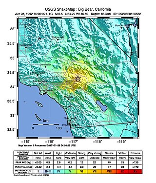
The 1992 Big Bear earthquake occurred at on June 28 in Big Bear Lake, California, with a moment magnitude of 6.5 and a maximum perceived intensity of VIII (Severe) on the Mercalli intensity scale. The earthquake occurred at a relatively shallow depth of 5 kilometers (3.1 mi).
The 1976 Moro Gulf earthquake and tsunami occurred on near the islands of Mindanao and Sulu, in the Philippines. It measured 8.0 on the moment magnitude scale occurring at a depth of 20 km (12 mi). The earthquake was accompanied by a destructive tsunami that resulted in a majority of the estimated 5,000 to 8,000 fatalities. It was the deadliest and strongest earthquake in the Philippines in 58 years since the 1918 Celebes Sea earthquake.
The 1991 Uttarkashi earthquake occurred at 02:53:16 Indian Standard Time (UTC+05:30) on 20 October with a moment magnitude of 6.8 and a maximum Mercalli intensity of IX (Violent). This thrust event was instrumentally recorded and occurred along the Main Central Thrust in the Uttarkashi and Gharwal regions of the Indian state of Uttarakhand. High intensity shaking resulted in the deaths of at least 768 people and the destruction of thousands of homes.

James Freeman Gilbert was an American geophysicist, best known for his work with George E. Backus on inverting geophysical data, and also for his role in establishing an international network of long-period seismometers.
The 1941 Andaman Islands earthquake struck the Andaman Islands on June 26 with a magnitude of 7.7 to 8.1. Details of this event are poorly known as much of Southeast Asia was in the turmoil of World War II. The quake caused severe damage in the Andaman Islands. The tsunami it triggered was reported along the Andaman and Nicobar Islands, India and British Ceylon. There may have been damage and deaths in Bangladesh, Myanmar, and Thailand due to the tsunami.

The preliminary reference Earth model (PREM) plots the average of Earth's properties by depth. It includes a table of Earth properties, including elastic properties, attenuation, density, pressure, and gravity.

A deep-focus earthquake in seismology is an earthquake with a hypocenter depth exceeding 300 km. They occur almost exclusively at convergent boundaries in association with subducted oceanic lithosphere. They occur along a dipping tabular zone beneath the subduction zone known as the Wadati–Benioff zone.
The 1954 Chlef earthquake struck El Asnam Province in French Algeria on 9 September at . The shock measured 6.7 on the moment magnitude scale and had a maximum Mercalli intensity of XI (Extreme). It destroyed Chlef, then named Orléansville, leaving over 1,243 people dead and 5,000 injured. Damage was estimated at $6 million. It was followed by multiple aftershocks. Algeria faces annual earthquakes and has undergone several changes to its earthquake building codes since its first earthquake engineering regulations from 1717.

The 2000 Tottori earthquake occurred on 6 October 2000, at with a moment magnitude of 6.7 and a maximum Mercalli intensity of VIII (Severe). The epicenter was near Yonago and Matsue. About $150 million in damage was caused and between 130 and 182 people were injured.

The 1918 Celebes Sea earthquake occurred on August 15 at 12:18 UTC near the Moro Gulf coast of Mindanao. It had a magnitude of 8.3 on the moment magnitude scale and a maximum perceived intensity of X (Extreme) on the Mercalli intensity scale. It triggered a tsunami of up to 7 m in height and the combined effects of the earthquake and tsunami led to the deaths of 52 people.
The 1946 Ancash earthquake in the Andes Mountains of central Peru occurred on November 10 at 17:43 UTC. The earthquake had a surface-wave magnitude of 7.0, and achieved a maximum Mercalli intensity scale rating of XI (Extreme). About 1,400 people are thought to have died from the event.
The 1906 Manasi earthquake (玛纳斯地震), also known as the Manas earthquake occurred in the morning of December 23, 1906, at 02:21 UTC+8:00 local time or December 22, 18:21 UTC. It measured 8.0–8.3 on the moment magnitude scale and 8.3 on the surface-wave magnitude scale. The epicenter of this earthquake is located in Manas County, Xinjiang, China. An estimated 280–300 people died and another 1,000 more were injured by the earthquake.
On April 13, 1923 at 15:31 UTC, an earthquake occurred off the northern coast of the Kamchatka Peninsula in the USSR, present-day Russia. The earthquake had a surface-wave magnitude (Ms ) of 6.8–7.3 and an estimated moment magnitude (Mw ) of 7.0–8.2. This event came just two months after a slightly larger earthquake with an epicenter struck south of the April event. Both earthquakes were tsunamigenic although the latter generated wave heights far exceeding that of the one in February. After two foreshocks of "moderate force", the main event caused considerable damage. Most of the 36 casualties were the result of the tsunami inundation rather than the earthquake.
The 1979 Yapen earthquake occurred on September 12 at 05:17:51 UTC. It had an epicenter near the coast of Yapen Island in Irian Jaya, Indonesia. Measuring 7.5 on the moment magnitude scale and having a depth of 20 km (12 mi), it caused severe damage on the island. At least 115 were killed due to shaking and a moderate tsunami.
On April 12, 1910, an earthquake struck with an epicenter off the northern coast of Taiwan. The earthquake measuring 8.1 had a hypocenter depth of 235.0 km (146.0 mi). In Taipei and Hsinchu, 13 homes totally collapsed, two partially collapsed, and an additional 57 were damaged. At least 204 homes were destroyed or damaged in Keelung, Shenkeng and Taoyuan. Sixty people died or were injured. Shaking was felt across Taiwan and the Penghu Islands; strong shaking was felt in the northern half of the island. The intermediate-depth of the earthquake suggest it originated from within the subducting Philippine Sea Plate which undergoes subduction.


