1970 Ancash earthquake

Last updated
1970 Peru earthquake
Statue of Christ at Cemetery Hill overlooking old Yungay.jpg
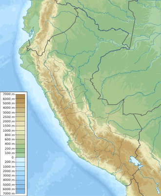
Peru physical map.svg
Green pog.svg
Yungay
Green pog.svg
Lima
Bullseye1.png
UTC  time1970-05-31 20:23:29
ISC  event 796163
USGS-ANSS ComCat
Local date31 May 1970 (1970-05-31)
Local time15:23:29
Duration~ 45 seconds [1] [2]
Magnitude7.9 Mw [3] [4]
Depth45 km (28 mi) [3]
Epicenter 9°24′S78°54′W / 9.4°S 78.9°W / -9.4; -78.9 [4]
Type Normal
Areas affected Peru
Max. intensity MMI VIII (Severe) [1]
Peak acceleration0.1 g at Lima [2]
Tsunami.38 m (1 ft 3 in) [5]
Casualties66,794–70,000 dead [5]
50,000 injured [5]

The 1970 Ancash earthquake (also known as the Great Peruvian earthquake) occurred on 31 May off the coast of Peru in the Pacific Ocean at 15:23:29 local time. Combined with a resultant landslide, it is the most catastrophic natural disaster in the history of Peru. Due to the large amounts of snow and ice included in the landslide that caused an estimated 66,000-70,000 casualties, it is also considered to be the world's deadliest avalanche.

Contents

Earthquake

USGS ShakeMap showing the earthquake's intensity 1970 Ancash earthquake intensity.jpg
USGS ShakeMap showing the earthquake's intensity

The undersea earthquake struck on a Sunday afternoon and lasted about 45 seconds. The shock affected the Peruvian regions of Ancash and La Libertad. The epicenter was located 35 km (22 mi) off the coast of Casma and Chimbote in the Pacific Ocean, where the Nazca plate is being subducted beneath the South American plate. It had a moment magnitude of 7.9 and a maximum Mercalli intensity of VIII (Severe). The focal mechanism and hypocentral depth of the earthquake show that the earthquake was a result of normal faulting within the subducting slab. [6]

Damage

The earthquake affected an area of about 83,000 km2, an area larger than Belgium and the Netherlands combined, in the north-central coast and the Sierra (highlands) of the Ancash Region and southern La Libertad Region. Reports of damage and casualties came from Tumbes to Pisco and Iquitos in the east. Damage and panic scenes were reported in some parts of Ecuador. Tremors were also felt in western and central Brazil.

It was a system-wide disaster, affecting such a widespread area that the regional infrastructure of communications, commerce, and transportation was destroyed. Economic losses surpassed half a billion US dollars. Cities, towns, villages—and homes, industries, public buildings, schools, electrical generation and distribution systems, water, sanitary and communications facilities—were seriously damaged or were destroyed.

Pat Nixon in Peru Consuelo Velasco 1970.jpg
Pat Nixon hospital Peru C3796-18.jpg
U.S. First Lady Pat Nixon led American aid efforts after the earthquake. She aided in taking relief supplies to earthquake victims (above) and visited children in hospitals (below).

The coastal towns and cities of Chimbote (the largest city in Ancash), Casma, Supe and Huarmey were hit hard; but the Andean valley known as the Callejón de Huaylas suffered the most intense and sweeping damage, with the regional capital, Huaraz, and Caraz and Aija being partially destroyed. Trujillo, the country's third-largest city, and Huarmey suffered minor damage.

In Chimbote, Carhuaz and Recuay, between 80% and 90% buildings were destroyed, affecting about three million people.

The Pan-American highway was also damaged, which made the arrival of humanitarian aid difficult. The Cañón del Pato hydroelectricity generator was damaged by the Santa River and the railway connecting Chimbote with the Santa Valley was left unusable on 60% of its route.

The Peruvian government has forbidden excavation in the area where the town of Yungay is buried, declaring it a national cemetery. The children who survived in the local stadium were resettled around the world. In 2000, the tragedy inspired the government to declare 31 May as Natural Disaster Education and Reflection Day, during which many schools practice an earthquake drill to commemorate the disaster.

Landslide

The northern wall of Mount Huascarán was destabilized, causing a rock, ice and snow avalanche and burying the towns of Yungay and Ranrahirca. The avalanche started as a sliding mass of glacial ice and rock about 910 metres (2,990 ft) wide and 1.6 km (1 mile) long. It advanced about 18 kilometres (11 mi) to the village of Yungay at an average speed of 280 to 335 km per hour. [7] The fast-moving mass picked up glacial deposits and by the time it reached Yungay, it is estimated to have consisted of about 80 million m3 of water, mud, rocks and snow.

Yungay Viejo - location of landslide 1970.jpg
Yungay Viejo (2,500 m) as seen from the cemetery hill. The light shaded area shows the location of the landslide (ice, mud, debris avalanche), in which a part of the western flank of Huascaran Norte broke (6,652 m). Yungay Nuevo is behind the shaded area in the center.

See also

Related Research Articles

<span class="mw-page-title-main">Chimbote</span> Place in Ancash, Peru

Chimbote ; Quechua: Chimputi) is the largest city in the Ancash Region and the 10th largest city in Peru. With a population of 425,367, it is the capital of both Santa Province and Chimbote District.

<span class="mw-page-title-main">Department of Ancash</span> Departments of Peru

Ancash is a department and region in western Peru. It is bordered by the departments of La Libertad on the north, Huánuco and Pasco on the east, Lima on the south, and the Pacific Ocean on the west. Its capital is the city of Huaraz, and its largest city and port is Chimbote. The name of the region originates from the Quechua word anqash, from anqas ('blue') or from anka ('eagle').

<span class="mw-page-title-main">Huaraz</span> City in Ancash, Peru

Huaraz, formerly designated as San Sebastián de Huaraz, is a city in Peru. It is the capital of the Ancash Region and the seat of government of Huaraz Province. The urban area's population is distributed over the districts of Huaraz and Independencia. The city is located in the middle of the Callejon de Huaylas valley and on the right side of the Santa river. The city has an elevation of approximately 3050 meters above sea level. The built-up area covers 8 square kilometers and has a population of 120,000 inhabitants, making it the second largest city in the central Peruvian Andes after the city of Huancayo. It is the 22nd largest city in Peru. Huaraz is the seat of the province's Roman Catholic Bishop and the site of the cathedral.

<span class="mw-page-title-main">Huascarán</span> Mountain in Peru

Huascarán, Nevado Huascarán or Mataraju is a mountain located in Yungay Province, Department of Ancash, Peru. It is situated in the Cordillera Blanca range of the western Andes. The southern summit of Huascarán, which reaches 6,768 metres (22,205 ft), is the highest point in Peru, the northern Andes, and in all of the earth's Tropics. Huascarán is the 4th highest mountain in South America after Aconcagua, Ojos del Salado, and Monte Pissis. Huascarán is ranked 25th by topographic isolation.

<span class="mw-page-title-main">Yungay, Peru</span> Town in Peru

Yungay, also known as Yungay Nuevo, is a town in the Ancash Region in north central Peru, South America.

The Santa Valley is an inter-andean valley in the Ancash Region in the north-central highlands of Peru. Due to its location between two mountain ranges, it is known as Callejón de Huaylas, the Alley of Huaylas, whereas "Huaylas" refers to the territorial division's name during the Viceroyalty of Peru.

<span class="mw-page-title-main">Ranrahirca</span>

The 1962 Ranrahirca Landslide was deadly landslide that affected the Ranrahirca District, alongside the river Santa, near Huascarán, the highest mountain in Peru. It was hit by massive avalanches of snow, rocks and mud, originating on the slopes of Huascarán and triggered by earthquakes on 10 January 1962 and on 31 May 1970. Over two thousand people from the village perished in the 1962 avalanche, along with the inhabitants of seven nearby settlements. In total about 3,500 died in the disaster. About 20,000 people died in the avalanches that resulted from the second earthquake. 400 survived from the second disaster.

<span class="mw-page-title-main">Casma River</span> River in Ancash region, Peru

The Casma River, which upstream is called Río Grande, is a river that crosses northern Casma province in the Ancash Region of Peru. It originates in the Black Mountain Range and drains into the Pacific Ocean. Major tributaries include the Sechín River (right).

<span class="mw-page-title-main">Yungay District</span> District in Ancash, Peru

Yungay district is a district in the Province of Yungay in the Ancash region, Peru. It was created by law on October 28, 1904.

The 1949 Olympia earthquake occurred on April 13 at 11:55:44 local time with a moment magnitude of 6.7 and a maximum Mercalli Intensity of VIII (Severe). The shock was located in the area between Olympia and Tacoma, and was felt throughout the state, as well as parts of Oregon, British Columbia, Idaho, and Montana. It is the largest recorded earthquake to occur in the Puget Sound region of Washington. Eight people were killed, a minimum of 64 people were injured, and the total damage is estimated at $25 million.

The 1972 Nicaragua earthquake occurred at 12:29:44 a.m. local time on December 23 near Managua, the capital of Nicaragua. It had a moment magnitude of 6.3 and a maximum MSK intensity of IX (Destructive). The epicenter was 28 km (17 mi) northeast of the city centre and a depth of about 10 km (6.2 mi). The earthquake caused widespread casualties among Managua's residents: 4,000–11,000 were killed, 20,000 were injured and over 300,000 were left homeless.

<span class="mw-page-title-main">1970 Tonghai earthquake</span> 1970 earthquake in southwest China and northern Vietnam

The 1970 Tonghai earthquake occurred at 01:00:41 local time on January 5 with a moment magnitude of 7.1 and a maximum Mercalli intensity of X (Extreme). The strike-slip rupture originated on the Red River Fault, which had not experienced an earthquake above magnitude 7 since 1700, and affected Tonghai County, Yunnan province, China. At least 10,000 people were killed, making it one of the deadliest in its decade. The tremor caused between US$5 and $25 million in damage, felt over an area of 8,781 km2 (3,390 sq mi). In Hanoi, North Vietnam, almost 483 km (300 mi) from the epicenter, victims left their homes as the rupture rumbled through the city.

<span class="mw-page-title-main">Lists of 21st-century earthquakes</span>

The following is a summary of significant earthquakes during the 21st century. In terms of fatalities, the 2004 Indian Ocean earthquake was the most destructive event with 227,898 confirmed fatalities, followed by the 2010 Haiti earthquake with about 160,000 fatalities, the 2008 Sichuan earthquake with 87,587 fatalities, the 2005 Kashmir earthquake suffered by Pakistan with 87,351 fatalities, and the 2023 Turkey–Syria earthquakes with at least 59,488 fatalities.

The 1982 North Yemen earthquake hit near the city of Dhamar, North Yemen on December 13. Measuring 6.2 on the moment magnitude scale, with a maximum perceived intensity of VIII (Severe) on the Mercalli intensity scale, as many as 2,800 people were killed and another 1,500 injured. The shock occurred within several hundred kilometers of a plate boundary in a geologically complex region that includes active volcanoes and seafloor spreading ridges. Yemen has a history of destructive earthquakes, though this was the first instrumentally recorded event to be detected on global seismograph networks.

The 1996 Chimbote earthquake occurred on February 21 at 07:51 local time about 130 km off the coast of northern Peru, near the Peru–Chile Trench. The earthquake had a moment magnitude of 7.5 and occurred at 25.0 km (15.5 mi) depth.

<span class="mw-page-title-main">1918 San Jacinto earthquake</span> Earthquake in Southern California

The 1918 San Jacinto earthquake occurred in extreme eastern San Diego County in Southern California on April 21 at 14:32:29 local time. The shock had a moment magnitude of 6.7 and a maximum Mercalli intensity of IX (Violent). Several injuries and one death occurred with total losses estimated to be $200,000.

<span class="mw-page-title-main">1970 Huascarán debris avalanche</span> Deadliest avalanche in the history in Peru

The 1970 Huascarán Debris Avalanche occurred on May 30 1970, when a debris avalanche and mudflow triggered by the Ancash earthquake destroyed the Peruvian town of Yungay and ten nearby villages, leaving up to 30,000 people dead. It is the deadliest avalanche or glacier-related disaster in history, surpassing the death toll from the previous deadliest avalanche disaster, the avalanches of White Friday on the Italian front of World War I and the third or fourth most deadly landslide-related disaster of the 20th century, after the Haiyuan landslides (China), the Armero tragedy (Colombia) and by some estimates the Khait landslide (Tajikistan).

The 1946 Ancash earthquake in the Andes Mountains of central Peru occurred on November 10 at 17:43 UTC. The earthquake had a surface-wave magnitude of 7.0, and achieved a maximum Mercalli intensity scale rating of XI (Extreme). About 1,400 people are thought to have died from the event.

The 1979 Saint Elias earthquake affected Alaska at 12:27 AKST on 28 February. The thrust-faulting Mw 7.5 earthquake had an epicenter in the Granite Mountains. Though the maximum recorded Modified Mercalli intensity was VII, damage was minimal and there were no casualties due to the remoteness of the faulting. Damage also extended across the border in parts of Yukon, Canada.

<span class="mw-page-title-main">Santo Domingo de Yungay</span> Former town in Peru

Yungay, currently known as Yungay Viejo and founded in 1540 as Santo Domingo de Yungay, was a town in Peru that served as the seat of the province of the same name in the Department of Ancash. Located 2,400 m.a.s.l., it was destroyed by a landslide that originated at the nearby Huascarán mountain due to the 1970 Ancash earthquake. 5,000 people disappeared during the event, with some 300 people surviving due to taking refuge in the local cemetery.

References

  1. 1 2 Plafker, Ericksen & Fernández Concha 1971, p. 545
  2. 1 2 Cluff, L.S. (1971), "Peru earthquake of May 31, 1970; Engineering geology observations" (PDF), Bulletin of the Seismological Society of America, 61 (3): 514, Bibcode:1971BuSSA..61..511C, doi:10.1785/BSSA0610030511, S2CID   132218116
  3. 1 2 ISC (2014), ISC-GEM Global Instrumental Earthquake Catalogue (1900–2009), Version 1.05, International Seismological Centre
  4. 1 2 Utsu, T. R. (2002), "A List of Deadly Earthquakes in the World: 1500–2000", International Handbook of Earthquake & Engineering Seismology, Part A, Volume 81A (First ed.), Academic Press, p. 708, ISBN   978-0124406520
  5. 1 2 3 PAGER-CAT Earthquake Catalog, Version 2008_06.1, United States Geological Survey, September 4, 2009
  6. Dewey, J.W.; Spence, W. (1979). Wyss, M. (ed.). "Seismic gaps and source zones of recent large earthquakes in coastal Peru". Pure and Applied Geophysics. 117 (6): 1148–1171. Bibcode:1979PApGe.117.1148D. doi:10.1007/BF00876212. S2CID   140643448.
  7. Plafker, Ericksen & Fernández Concha 1971 , p. 543

Sources