
Pisco is a city located in the Department of Ica of Peru, the capital of the Pisco Province. The city is around 9 metres above sea level. Pisco was founded in 1640, close to the indigenous emplacement of the same name. Pisco originally prospered because of its nearby vineyards and became noted for its grape brandy or pisco which was exported from its port. Pisco has an estimated population of 104,656.
The 1857 Fort Tejon earthquake occurred at about 8:20 a.m. on January 9 in central and Southern California. One of the largest recorded earthquakes in the United States, with an estimated moment magnitude of 7.9, it ruptured the southern part of the San Andreas Fault for a length of about 225 miles, between Parkfield and Wrightwood.
The 2005 northern Peru earthquake occurred on September 25 at 20:56 local time with a magnitude of 7.5. It resulted in the deaths of at least 20 people.

The 2007 Peru earthquake, which measured 8.0 on the moment magnitude scale, hit the central coast of Peru on August 15 at 23:40:57 UTC and lasted two minutes. The epicenter was located 150 km (93 mi) south-southeast of Lima at a depth of 39 km (24 mi). The United States Geological Survey National Earthquake Information Center reported that it was a Very strong earthquake. The Peruvian government stated that 595 people were killed by the quake.

In the early morning hours of August 16, 1931, a powerful earthquake occurred in West Texas with a maximum Mercalli intensity of VIII (Severe). Estimates of its magnitude range between 5.8–6.4 mb, making it the most powerful earthquake ever recorded in Texas history. Its epicenter was near the town of Valentine, Texas; there, the earthquake caused damage to many homes and buildings. The earthquake may have been caused by movement along oblique-slip faulting in West Texas, the most seismically-active region in the state. Shaking from the earthquake was perceptible within a 400 mi (640 km) radius of the epicenter, affecting four U.S. states and northern Mexico. Several foreshocks and aftershocks accompanied the primary temblor, with the aftershocks continuing until at least November 3, 1931. The main earthquake caused no fatalities, though several people sustained minor injuries; the damage in Valentine amounted to $50,000–$75,000.

The 2010 Chile earthquake and tsunami occurred off the coast of central Chile on Saturday, 27 February at 03:34 local time, having a magnitude of 8.8 on the moment magnitude scale, with intense shaking lasting for about three minutes. It was felt strongly in six Chilean regions that together make up about 80 percent of the country's population. According to the United States Geological Survey (USGS) the cities experiencing the strongest shaking—VIII (Severe) on the Mercalli intensity scale (MM)—were Concepción, Arauco, and Coronel. According to Chile's Seismological Service, Concepción experienced the strongest shaking at MM IX (Violent). The earthquake was felt in the capital Santiago at MM VII or MM VIII. Tremors were felt in many Argentine cities, including Buenos Aires, Córdoba, Mendoza, and La Rioja. Tremors were felt as far north as the city of Ica in southern Peru.
The 1687 Peru earthquake occurred at 11:30 UTC on 20 October. It had an estimated magnitude of 8.4–8.7 and caused severe damage to Lima, Callao and Ica. It triggered a tsunami and overall about 5,000 people died.
The 2012 Costa Rica earthquake occurred at 08:42 local time on September 5. The epicenter of the 7.6 Mw earthquake was in the Nicoya Peninsula, 11 kilometers east-southeast of Nicoya. A tsunami warning was issued shortly afterwards, but later cancelled. Two people are known to have died, one from a heart attack and another, a construction worker, crushed by a collapsing wall. It was the second strongest earthquake recorded in Costa Rica's history, following the 1991 Limon earthquake.
The 1974 Lima earthquake occurred on October 3 at 14:21 UTC. It was located at about 80 km southwest of Lima, Peru. The magnitude of the earthquake was put at 8.1 , or 7.8. The earthquake caused 78 deaths and left 2,400 injured.

The 2016 Ecuador earthquake occurred on April 16 at with a moment magnitude of 7.8 and a maximum Mercalli intensity of VIII (Severe). The very large thrust earthquake was centered approximately 27 km (17 mi) from the towns of Muisne and Pedernales in a sparsely populated part of the country, and 170 km (110 mi) from the capital Quito, where it was felt strongly. Regions of Manta, Pedernales and Portoviejo accounted for over 75 percent of total casualties. Manta's central commercial shopping district, Tarqui, was completely destroyed. Widespread damage was caused across Manabí Province, with structures hundreds of kilometres from the epicenter collapsing. At least 676 people were killed and 16,600 people injured. President Rafael Correa declared a state of emergency; 13,500 military personnel and police officers were dispatched for recovery operations.
The 1992 Murindó earthquake occurred on October 18 at 15:11 UTC with an epicenter in the Department of Chocó, northern Colombia. The shallow magnitude 7.2 earthquake struck northwest of the town of Murindó, killing ten and injured more than a hundred. Thirty-three municipalities were severely damaged.
In early 1981 the eastern Gulf of Corinth, Greece was struck by three earthquakes with a magnitude greater than 6 over a period of 11 days. The earthquake sequence caused widespread damage in the Corinth–Athens area, destroying nearly 8,000 houses and causing 20–22 deaths.
The 1940 Lima earthquake occurred on May 24 at 11:35 a.m. PST with a magnitude of Mw 8.2 on the moment magnitude scale. Shaking from this powerful earthquake was felt throughout the country, and in Ecuador and Chile. An estimated 179 to 300 Peruvians lost their lives while 3,500 left injured by the earthquake. The earthquake was centered near the coastal cities of Huacho and Huaura, about 150 km (93 mi) north of the Peruvian capital, Lima. A tsunami of up to two meters was generated without major damage.
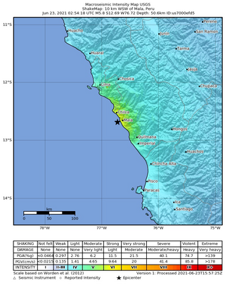
The 2021 Mala earthquake, with a Richter magnitude of 6.0 and moment magnitude of 5.9, struck on June 22, 2021, at 21:54:18 local time (UTC-5) with an epicenter off the coast of Mala in the department of Lima. Following the main event, there were more than 15 aftershocks, with the largest being a magnitude 4.8 event at 07:03 local time on June 23.

A major earthquake struck northern Peru on November 28, 2021, 5:52 a.m. local time with a magnitude of 7.5 on the moment magnitude scale between the Amazonas and Loreto departments of Peru. A maximum Modified Mercalli intensity (MMI) of VII was reported in the town of Santa Maria de Nieva according to the Geological Institute of Peru.

An earthquake struck the Department of Lima, Peru on May 12, 2022. The earthquake caused minor damage and some casualties in the Lima area. Several homes collapsed due to the earthquake.

On 19 September 2022, a moment magnitude 7.7 earthquake struck between the Mexican states of Michoacán and Colima at 13:05:06 local time. The earthquake had a depth of 16.9 km (10.5 mi), resulting in a maximum intensity of VIII (Severe) on the Modified Mercalli intensity scale. The USGS reported the epicentre was 37 km (23 mi) southeast of the town of Aquila. Two people were killed and at least 35 others were injured across several states. A magnitude 6.8 aftershock struck on 22 September, causing three more deaths.
