The 2005 Lake Tanganyika earthquake occurred at on 5 December with a moment magnitude of 6.8 and a maximum Mercalli intensity of X (Extreme). The shock occurred along the East African Rift, an active continental rift zone in East Africa that is characterized by normal faulting, and initiated at a depth of 22 kilometers (14 mi).
In seismology, doublet earthquakes – and more generally, multiplet earthquakes – were originally identified as multiple earthquakes with nearly identical waveforms originating from the same location. They are now characterized as distinct earthquake sequences having two main shocks of similar magnitude, sometimes occurring within tens of seconds, but sometimes separated by years. The similarity of magnitude – often within 0.4 magnitude – distinguishes multiplet events from aftershocks, which start at about 1.2 magnitude less than the parent shock and decrease in magnitude and frequency according to known laws.
The 2002 Kalehe earthquake occurred on October 24 at 06:08 UTC. This earthquake had a magnitude 6.2, and the epicenter was located in Democratic Republic of the Congo, near Lake Kivu. Two people were reported dead. Building damage was reported in Goma, Lwiro, Kalehe, and Mugeri. The seismicity, volcanism, and uplift in the basin of Lake Kivu delimits the rift of a tectonic plate. Lake Kivu belongs to the western branch of the East African Rift System (EARS). The western branch is usually divided into several segments, and Lake Kivu belongs to the northern segment.

The 1994 offshore Sanriku earthquake occurred on December 28, 1994, at 12:19 UTC. This was a magnitude 7.7 earthquake with epicenter located in the Pacific Ocean at about 180 km east of Hachinohe, Aomori. The intensity reached shindo 6 in Hachinohe, Aomori, about 187.6 km from epicenter. It could be felt in Tokyo, about 632.9 km from epicenter, with shindo 2. The Japanese Meteorological Agency put the magnitude at 7.5. Slip associated with this earthquake continued for more than a year and it has been termed an 'ultra-slow earthquake'.
The 1992 Roermond earthquake occurred on 13 April, around 3:20 AM with a moment magnitude of 5.3 and a maximum Mercalli intensity of VIII (Severe). Striking on the Peel Boundary Fault, a normal fault near Roermond, it was the strongest recorded earthquake in the Netherlands and in Northwestern Europe, and caused substantial damage to older buildings in the Netherlands and adjacent countries of Belgium and Germany. A series of aftershocks followed.
The 1968 Tokachi earthquake occurred on May 16 at 0:49 UTC in the area offshore of Aomori and Hokkaido. The magnitude of this earthquake was put at 8.3. The intensity of the earthquake reached shindo 5 in Aomori, Aomori and Hakodate, Hokkaido.
The 1935 Helena earthquake occurred at in Montana, with an epicenter near Helena. It had a magnitude of 6.2 on the surface-wave magnitude scale and a maximum perceived intensity of VIII (Severe) on the Mercalli intensity scale. The temblor on that date was the largest of a series of earthquakes that also included a large aftershock on October 31 of magnitude 6.0 and a maximum intensity of VIII. Two people died in the mainshock and two others died as a result of the October 31 aftershock. Property damage was over $4 million.
The 1948 Litang earthquake (1948年理塘地震) occurred on May 28, 1948, at 07:11 UTC. It was located near Litang, China. Now situated in the Sichuan Province, Litang County was then called Lihua (理化) County and belonged to the defunct Xikang Province. The earthquake had a magnitude of 7.2, or 7.3.

A magnitude 5.9 earthquake struck Tanzania 27 km (17 mi) east northeast of Nsunga, Kagera Region on September 10 at a depth of 40 km (25 mi). The shock had a maximum intensity of VII (Very strong). Nineteen people were killed and 253 injured in Tanzania, while four people were killed in Kamuli and seven others were injured in the Rakai District of neighbouring Uganda.
The 1969 Tulbagh earthquake occurred at 20:03:33 UTC on 29 September. It had a magnitude of 6.3 and a maximum felt intensity of VIII (Severe) on the Modified Mercalli intensity scale. It caused widespread damage in the towns of Ceres, Tulbagh and Wolseley and led to 12 deaths. The earthquake was a result of strike-slip faulting along a NW-SE trending near vertical fault plane, as shown by the focal mechanism and the distribution of aftershocks.
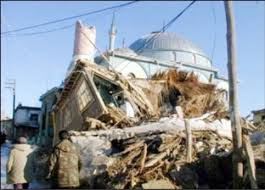
The Afyon Province of western Turkey was struck by an earthquake measuring 6.5 on 3 February 2002 at 10:11 local time. It had a maximum felt intensity of VIII (Severe) on the Modified Mercalli intensity scale. It damaged hundreds of buildings and caused the deaths of 44 people and a further 318 injuries.
In 1954, the state of Nevada was struck by a series of earthquakes that began with three magnitude 6.0+ events in July and August that preceded the Mw 7.1–7.3 mainshock and M 6.9 aftershock, both on December 12. All five earthquakes are among the largest in the state, and the largest since the Cedar Mountain earthquake of 1932 and Pleasant Valley event in 1915. The earthquake was felt throughout much of the western United States.
The 1994 Mascara earthquake occurred on August 18 at 02:13 local time with an epicenter in a rural part of Algeria. The earthquake measured 5.8 on the moment magnitude scale (Mw ) and had a depth of 10 km (6.2 mi). It caused the deaths of 171 people, left up to 12,500 homeless, and destroyed thousands of homes in Mascara Province. Many homes were damaged or destroyed due to poor building quality which collapsed on the inhabitants and resulted in a majority of the casualties. The national government launched a rapid response effort in its aftermath.
The 1990 Carlentini earthquake occurred off the Sicilian coast, 20 km east northeast from the town of Augusta, Sicily on 13 December at 01:24 local time. The moderately-sized earthquake measuring 5.6 on the moment magnitude scale (Mw ) resulted in the deaths of 19 people and caused at least 200 injuries. It also inflicted significant damage in the region, leaving 2,500 homeless.
Between May 1990 and April 1991, an earthquake sequence occurred in the Department of San Martín, northern Peru. Three large earthquakes of magnitudes (Mw ) 6.5–6.9 occurred in the same region across 11 months, causing extensive damage. At least 189 people were killed in these earthquakes.
The second shock in the 1962 Irpinia earthquake sequence was the largest and most destructive in a series of earthquakes in the southern Apennines. It occurred on 21 August at 18:19 CET, measuring 6.15 and assigned a maximum intensity of IX (Violent). It was preceded by an Mw 5.68 foreshock, and followed by a 5.34 aftershock. The earthquakes resulted in nearly 20 fatalities and significant property losses.
The 1979 Saint Elias earthquake affected Alaska at 12:27 AKST on 28 February. The thrust-faulting 7.5 earthquake had an epicenter in the Granite Mountains. Though the maximum recorded Modified Mercalli intensity was VII, damage was minimal and there were no casualties due to the remoteness of the faulting. Damage also extended across the border in parts of Yukon, Canada.
The 1895 Charleston earthquake, also known as the Halloween earthquake, occurred on October 31, at 05:07 CST near Charleston, Missouri. It had an estimated moment magnitude of 5.8–6.6 and evaluated Modified Mercalli intensity of VIII (Severe). The earthquake caused substantial property damage in the states of Missouri, Illinois, Ohio, Alabama, Iowa, Kentucky, Indiana, and Tennessee. Shaking was widespread, being felt across 23 states and even in Canada. At least two people died and seven were injured.
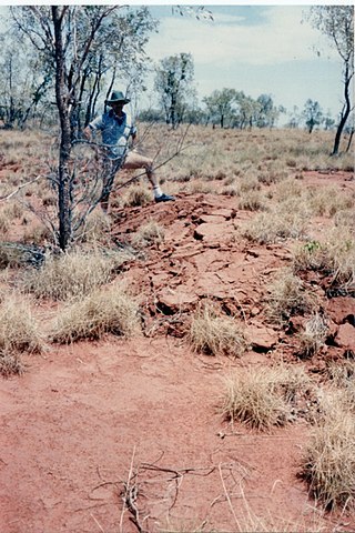
On 22 January 1988, a sequence of destructive earthquakes measuring 6.2, 6.3, and 6.6 struck southwest of Tennant Creek, Australia which was felt as far north as Darwin and in other regions of the country. The largest event of the sequence was the largest earthquake ever recorded in mainland Australia since records began in 1800. An intensity of IX (Violent) was observed. Despite the large magnitude of the earthquakes and a close proximity to a town, in a country where earthquakes of this size are not common, damages were limited. Thousands of aftershocks were reported and felt across Northern Territory.
In 1990, present day South Sudan was rocked by a series of violent earthquakes. It started with the largest event (Mw 7.2), and continued with multiple very large aftershocks for the next couple of months. The earthquake sequence ruptured over a length of 50 km (31 mi). It contains some of the largest recorded earthquakes anywhere in Africa.
