The 1202 Syria earthquake struck at about dawn on 20 May 1202 with an epicenter in southwestern Syria. The earthquake is estimated to have killed around 30,000 people. It was felt over an extensive area, from Sicily to Mesopotamia and Anatolia to upper Egypt, mostly affecting the Ayyubid Sultanate and the Kingdom of Jerusalem. The cities of Tyre, Acre and Nablus were heavily damaged. A magnitude of 7.6 has been estimated with damage up to XI on the Mercalli intensity scale.

The Galilee earthquake of 1837, often called the Safed earthquake, shook the Galilee on January 1 and is one of a number of moderate to large events that have occurred along the Dead Sea Transform fault system that marks the boundary of two tectonic plates; the African plate on the west and the Arabian plate on the east. Intensity assessments for the event were VIII (Damaging) on the Medvedev–Sponheuer–Karnik scale and VIII on the European Macroseismic Scale.
The 1971 Bingöl earthquake was a 6.6–6.7 earthquake that occurred at on 22 May. It had a surface-wave magnitude of 6.9 and a maximum intensity of IX (Violent) on the Mercalli intensity scale, killing 755–1,000 people. Bingöl was largely destroyed, as well as many houses in the nearby Bingöl plain. Surface displacement of 38 km (24 mi) and various other surficial effects were directly caused by the earthquake.
The 1303 Crete earthquake occurred at about dawn on 8 August. It had an estimated magnitude of about 8, a maximum intensity of IX (Violent) on the Mercalli intensity scale, and triggered a major tsunami that caused severe damage and loss of life on Crete and at Alexandria. It badly damaged the Lighthouse of Alexandria.
The 1927 Jericho earthquake was a devastating event that shook Mandatory Palestine and Transjordan on July 11 at . The epicenter of the earthquake was in the northern area of the Dead Sea. The cities of Jerusalem, Jericho, Ramle, Tiberias, and Nablus were heavily damaged and at least 287, as many as 400, were estimated to have been killed.
The 1955 Alexandria earthquake occurred on September 12 at 06:09 UTC. The epicenter was located in the eastern Mediterranean, offshore of Alexandria, Egypt. The earthquake had a magnitude of Ms 6.3.
Two major earthquakes occurred in the Near East on 18 March and 29 May, AD 1068. The two earthquakes are often amalgamated by contemporary sources. The first earthquake had its epicentre somewhere in the northwestern part of the Arabian Peninsula around Tabuk, while the second was most damaging in the city of Ramla in Palestine, some 500 km to the northwest.
The 1969 Sharm El Sheikh earthquake occurred on March 31 off the southern Sinai Peninsula in northeastern Egypt. The epicenter was located near Shadwan island, southwest of the city of Sharm El Sheikh, at the confluence of the Red Sea and the Gulf of Suez. This normal-slip shock measured 6.6 on the moment magnitude scale, had a maximum reported intensity of VII on the Mercalli intensity scale, and was responsible for several deaths and injuries.
The 1780 Tabriz earthquake occurred at 01:15 local time on 8 January. It had an estimated magnitude of 7.4 and a maximum felt intensity of IX on the Mercalli intensity scale. The city of Tabriz was almost completely destroyed. The number of reported casualties varies from 40,000 to as many as 200,000, with 50,000 being a more likely estimate.
The 1953 Paphos earthquake struck British Cyprus on the morning of 10 September, at 06:05 EET. It had a magnitude of Ms 6.5 on the surface-wave magnitude scale, and had a maximum intensity of X (Extreme) on the Modified Mercalli intensity scale. The epicenter of this earthquake was situated off the island's west coast, near the city of Paphos. At least 40 people died and 100 were injured. It was also felt in Rhodes, Turkey, Egypt, Lebanon and Kastellorizo.
The 1856 Heraklion earthquake, also known as the Crete earthquake or Rhodes earthquake, occurred on the morning of October 12 at 02:45 am local time. This extremely catastrophic earthquake had an estimated magnitude of 7.7 to 8.3 at a depth of approximately 61 to 100 km. The earthquake was felt over a very wide area extending from Sicily, Italy to the Levant and North Africa. On the Greek island of Crete, the effects of the earthquake were cataclysmic, over 500 bodies were recovered in the city of Heraklion. Shockwaves from the earthquake were felt intensely, covering all of the Ottoman Empire; present-day Turkey, Cyprus and the Middle East where damage and human losses were reported. In Malta, the Għajn Ħadid Tower—a coastal watchtower built around the year 1638—was severely damaged in the earthquake, when its upper floor collapsed. In Cairo, Egypt, the earthquake destroyed buildings, created seiches in canals, and killed several people. Off the Egyptian and Italian coasts, sailors reported feeling a seaquake.
The 1833 Nepal–India earthquake occurred on August 26 at 22:58 local time (NPT). This earthquake had an estimated moment magnitude of 7.6–7.9 and struck with an epicenter somewhere in or near the Kathmandu Valley. The earthquake caused major destruction in numerous towns and villages in Nepal, northern India, and Tibet. The earthquake was also felt in Chittagong, Bangladesh. Despite the extent of the damage, the number of fatalities resulting from the earthquake was surprisingly low, at approximately 500. This was because the mainshock was preceded by two smaller but intense foreshocks earlier that day, causing many residents to take refuge outside their homes.

The 1834 Java earthquake struck the Dutch East Indies island of Java, in the city of Bogor. The earthquake occurred on the morning of October 11, 1834. It was assigned VIII (Severe) to IX (Violent) on the Modified Mercalli intensity scale.
The 1941 Sa'dah earthquake or the Jabal Razih earthquake occurred on January 11 in Razih District of the Mutawakkilite Kingdom of Yemen. The earthquake had a surface-wave magnitude of 5.8–6.5 and a shallow focal depth. Despite the moderate size of this earthquake, an estimated 1,200 people perished and at least 200 injured. With a maximum MSK-64 intensity assigned at VIII, it destroyed many villages and collapsed homes in the region of North Yemen.
The 1872 Amik (Antakya) earthquake occurred on April 3 with an epicenter within the Amik Valley in the Ottoman Empire. Earthquake had an estimated magnitude of Mw 7.0–7.2 or Ms 7.2 and maximum MSK 64 rating of XI (Catastrophic). Turkey and Syria were devastated by this earthquake, and the region lost at least 1,800 residents.

The 1641 Tabriz earthquake occurred on the night of February 5 in present-day East Azerbaijan province, Iran. The earthquake had an estimated surface-wave magnitude of 6.8 and an epicenter between Lake Urmia and the city of Tabriz. It was one of the most destructive earthquakes in the region, resulting in the loss of up to 30,000 lives.
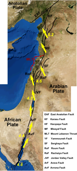
An earthquake struck the Jordan Rift Valley on December 5, AD 1033 and caused extreme devastation in the Levant region. It was part of a sequence of four strong earthquakes in the region between 1033 and 1035. Scholars have estimated the moment magnitude to be greater than 7.0 Mw and evaluated the Modified Mercalli intensity to X (Extreme). It triggered a tsunami along the Mediterranean coast, causing damage and fatalities. At least 70,000 people were killed in the disaster.
The 1899 Aydın–Denizli earthquake which struck present-day Turkey on September 20 resulted in between 1,117 and 1,470 fatalities. Heavy damage was reported in the provinces of Aydın and Denizli. The shallow normal-faulting earthquake had a maximum Modified Mercalli intensity of IX (Violent). Estimates of the seismic magnitude range from 6.5 to 7.1 .
The Marash earthquake occurred in the area of Marash during the early morning hours of November 29, 1114. It had an estimated surface-wave magnitude between 7.4 and 7.7 and an epicenter location in modern-day Turkey. The mainshock was preceded by two destructive foreshocks in August and November that same year. At least 40,000 people were killed in the earthquake; a number contested by historians due to the small population in the area at the time. These earthquakes were associated with seismic activity on the East Anatolian Fault.
