
The 2002 Denali earthquake occurred at 22:12:41 UTC November 3 with an epicenter 66 km ESE of Denali National Park, Alaska, United States. This 7.9 Mw earthquake was the largest recorded in the United States in 37 years. The shock was the strongest ever recorded in the interior of Alaska. Due to the remote location, there were no fatalities and only one injury.
The 1995 Antofagasta earthquake occurred on July 30 at 05:11 UTC with a moment magnitude of 8.0 and a maximum Mercalli intensity of VII. The Antofagasta Region in Chile was affected by a moderate tsunami, with three people killed, 58 or 59 injured, and around 600 homeless. Total damage from the earthquake and tsunami amounted to $1.791 million.
The 1971 Bingöl earthquake was a Mw 6.6 earthquake that occurred at on 22 May. It had a surface-wave magnitude of 6.9 and a maximum intensity of VIII (Severe) on the Mercalli intensity scale, killing 755–1,000 people.
The 2002 Burica earthquake occurred on off the coast of Panama. It had a magnitude of 6.5. The epicenter was located off the southeastern coast of Burica Peninsula, close to the Costa Rica–Panama border. Some homes collapsed and at least 11 people were reported injured, both in Panama and in Costa Rica. The strongest intensity reached VII in Puerto Armuelles, Panama. It was felt with III (Weak) to IV (Light) around San Jose, Costa Rica. Shops in the center of Puerto Armuelles suffered from loss such as fallen merchandise and broken window glass. This earthquake occurred along the Panama Fracture Zone.

The Sagaing Fault is a major fault in Myanmar, a mainly continental right-lateral transform fault between the Indian Plate and Sunda Plate. It links the divergent boundary in the Andaman Sea with the zone of active continental collision along the Himalayan front. It passes through populated cities of Mandalay, Yamethin, Pyinmana, the capital Naypyidaw, Toungoo and Pegu before dropping off into the Gulf of Martaban, running for a total length of over 1200 kilometers.
The 1990 Upland earthquake occurred at on February 28 with a moment magnitude of 5.7 and a maximum Mercalli Intensity of VII. This left-lateral strike-slip earthquake occurred west of the San Andreas Fault System and injured thirty people, with total losses of $12.7 million. Many strong motion instruments captured the event, with an unexpectedly high value seen on water tank near the epicentral area.
The 1992 Murindó earthquake occurred on October 18 at 15:11 UTC with an epicenter in the Department of Chocó, northern Colombia. The shallow magnitude 7.2 earthquake struck northwest of the town of Murindó, killing ten and injured more than a hundred. Thirty-three municipalities were severely damaged.
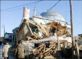
The Afyon Province of western Turkey was struck by an earthquake measuring 6.5 on 3 February 2002 at 10:11 local time. It had a maximum felt intensity of VIII (Severe) on the Modified Mercalli intensity scale. It damaged hundreds of buildings and caused the deaths of 44 people and a further 318 injuries.
In 1954, the state of Nevada was struck by a series of earthquakes that began with three magnitude 6.0+ events in July and August that preceded the Mw 7.1–7.3 mainshock and M 6.9 aftershock, both on December 12. All five earthquakes are among the largest in the state, and the largest since the Cedar Mountain earthquake of 1932 and Pleasant Valley event in 1915. The earthquake was felt throughout much of the western United States.
The 1979 Ghaenat earthquakes were a series of large earthquakes in Qaen County, Khorasan Province, northeast Iran, near the Afghanistan border. The first mainshock, known as the Korizan earthquake with a surface wave magnitude (Ms ) of 6.6 and moment magnitude (Mw ) of 6.8, struck on November 14, while the Ms 7.1 or Mw 7.2 Koli-Boniabad earthquake struck on November 27. The two mainshocks were assigned a maximum Modified Mercalli intensity of VIII (Severe) and X (Extreme), respectively. The earthquakes caused extensive damage throughout northeastern Iran, killing an estimated 297 to 440 people and left at least 279 injured.
The 2021 South Sandwich Islands earthquakes were a pair of powerful earthquakes, followed by many strong aftershocks which struck along the South Sandwich Trench in August 2021. The quakes measured 7.5 and 8.1 on the moment magnitude scale, according to the United States Geological Survey. The mainshock is tied with another event in 1929 as the largest earthquake ever recorded in this region, and is tied with the 2021 Kermadec Islands earthquake as the second largest earthquake of 2021.
The 1990 Carlentini earthquake occurred off the Sicilian coast, 20 km east northeast from the town of Augusta, Sicily on 13 December at 01:24 local time. The moderately-sized earthquake measuring 5.6 on the moment magnitude scale (Mw ) resulted in the deaths of 19 people and caused at least 200 injuries. It also inflicted significant damage in the region, leaving 2,500 homeless.
The 2016 Alborian Sea earthquake struck offshore, north northeast of Al Hoceïma, Morocco in the Strait of Gibraltar on January 25 at 04:22:02 UTC, or roughly 05:22:02 West Africa Time. The strongest in the Alboran Sea, the earthquake measured 6.3–6.4 on the moment magnitude scale (Mw ) at a shallow hypocenter depth of 12 km (7.5 mi). Assigned a maximum Modified Mercalli scale intensity of VI (Strong), the earthquake caused one fatality, at least 30 injuries, and moderate damage in Morocco and Spain.
The 1969 Alaşehir earthquake occurred on March 28 at 03:48 local time near the city of Alaşehir in Turkey's Manisa Province. The Mw 6.8 earthquake struck at 10 km (6.2 mi) depth. It had a MSK 64 intensity of VIII (Destructive). At least 53 people were killed in the earthquake.
The 1980 Nepal earthquake devastated the Nepal–India border region on the evening of July 29. The epicenter of the 6.6 earthquake was located in Nepal, northwest of Khaptad National Park. At least 200 people died and 5,600 were injured in the disaster. Extensive damage occurred on both sides of the border, amounting to 245 million USD.
The 1997 Bojnurd earthquake occurred on 4 February at 14:07 IRST in Iran. The epicenter of the 6.5 earthquake was in the Kopet Dag mountains of North Khorasan, near the Iran–Turkmenistan border, about 579 km (360 mi) northeast of Tehran. The earthquake is characterized by shallow strike-slip faulting in a zone of active faults. Seismic activity is present as the Kopet Dag is actively accommodating tectonics through faulting. The earthquake left 88 dead, 1,948 injured, and affected 173 villages, including four which were destroyed. Damage also occurred in Shirvan and Bojnord counties. The total cost of damage was estimated to be over US$ 30 million.
The 1977 Bob–Tangol earthquake struck Kerman province of Iran on December 20, 1977 at 03:04 Iran Standard Time. The earthquake measured 5.9 and struck at a depth of 22.7 km (14.1 mi). A maximum Modified Mercalli intensity of VII was evaluated based on damage. It had a strike-slip focal mechanism, which was unusual as the source structure was a thrust fault. It was part of a sequence of strong earthquakes along the 400 km (250 mi) Kuh Banan Fault. Between 584 and 665 people perished while a further 500–1,000 were injured; thousands were also made homeless. Casualties from the earthquake was considered moderate due to the sparsely populated area it affected. Preceded by foreshocks the month before, many residents became wary of a larger earthquake and took refuge outside their homes, contributing to the moderate death toll. However, there were none immediately before the mainshock so many were still in their homes when it struck. Aftershocks were felt for several months, some causing additional damage.
On 06:46:13 CET on 12 January 1956, a rather unusual earthquake measuring 5.8 on the moment magnitude scale struck just southeast of Budapest under Dunaharaszti at a depth of 15 km. The earthquake had a maximum European macroseismic intensity of VIII (Heavily damaging). The earthquake was felt throughout Hungary other than the eastern and western edges of the country. The event was preceded by 31 other weaker events. Widespread damage to homes and other structures were caused, 2 were killed and 48 were injured. The earthquake was one of the strongest to ever strike Hungary, and the worst during the 20th century.
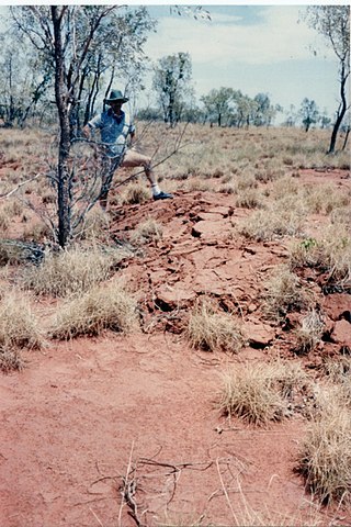
On 22 January 1988, a sequence of destructive earthquakes measuring 6.2, 6.3, and 6.6 struck southwest of Tennant Creek, Australia which was felt as far north as Darwin and in other regions of the country. The largest event of the sequence was the largest earthquake ever recorded in mainland Australia since records began in 1800. An intensity of IX (Violent) was observed. Despite the large magnitude of the earthquakes and a close proximity to a town, in a country where earthquakes of this size are not common, damages were limited. Thousands of aftershocks were reported and felt across Northern Territory.
The 1957 Sangchal earthquake struck northern Iran's Mazandaran province on 2 July 1957. It had a moment magnitude of 6.6 or 7.1 (Mw ), focal depth of 15 km (9.3 mi), and maximum Modified Mercalli intensity of IX (Violent). It devastated many communities in the Alborz Mountains and caused an estimated 1,500 fatalities. Damage was estimated at US$ 25 milion.

