Moyo Town

Last updated

Moyo
Uganda location map.svg
Red pog.svg
Moyo
Location in Uganda
Coordinates: 03°39′18″N31°43′12″E / 3.65500°N 31.72000°E / 3.65500; 31.72000
Country Flag of Uganda.svg Uganda
Region Northern Uganda
Sub-region West Nile sub-region
District Moyo District
Elevation
2,966 ft (904 m)
Population
 (2020 Estimate)
  Total12,100 [1]

Moyo, is the main municipal, administrative, and commercial center of Moyo District in the Northern Region of Uganda. The district headquarters are located here. [2]

Contents

Location

The town of Moyo is located approximately 158 kilometres (98 mi), by road, northeast of Arua, the largest city in the West Nile sub-region. [3] This is about 155 kilometres (96 mi) northwest of Gulu, the largest city in the Northern Region of Uganda. [4]

Moyo lies approximately 485 kilometres (301 mi) northwest of Kampala, the capital and largest city of Uganda. [5] The coordinates of Moyo Town are 3°39'18.0"N, 31°43'12.0"E (Latitude:3.654989; Longitude:31.720006). [6] Moyo Town Council sits at an average elevation of 904 metres (2,966 ft) above mean sea level. [7]

Population

In 2015, Uganda Bureau of Statistics (UBOS) estimated the population of the town at 10,700. In 2020, the population agency estimated the mid-year population of the town at 12,100 people. Of these, 6,300 (52.1 percent) were female and 5,800 (47.9 percent) were male. UBOS calculated the population growth rate of Moyo town to average 2.49 percent annually, between 2015 and 2020. [1]

Historical population
YearPop.±%
201510,700    
202012,100+13.1%
source: [1]

Points of interest

The following points of interest are located in Moyo town or close to the town: [6]

1. The headquarters of Moyo District Administration

2. The offices of Moyo Town Council

3. Moyo Airport, a civilian airport administered by the Civil Aviation Authority of Uganda.

4. Moyo Central Market

5. Koboko–Yumbe–Moyo Road makes a T-junction with the Atiak–Adjumani–Moyo–Afoji Road in the middle of town. [8]

6. Moyo General Hospital, a 176-bed public hospital administered by the Uganda Ministry of Health

7. Moyo Campus of Uganda Martyrs University.

See also

Related Research Articles

<span class="mw-page-title-main">Adjumani District</span> District in Northern Region, Uganda

Adjumani District is a district in Northern Uganda. Like most other Ugandan districts, it is named after its 'chief town', Adjumani, where the district headquarters are located.

<span class="mw-page-title-main">Arua District</span> District in Northern Uganda, Uganda

Arua District is a district in the Northern Region of Uganda. Like many other Ugandan districts, it shares its name with its administrative center of Arua. The name Arua is said to be derived from the Lugbara name for prison (Arujo) and prisoner (Aru), since the white settlers had a detention center at Arua Hill.

<span class="mw-page-title-main">Moyo District</span> District in Northern Uganda, Uganda

Moyo District is a district in Northern Region of Uganda. Like many other Ugandan districts, it is named after its "chief town", Moyo, where the district headquarters are located.

<span class="mw-page-title-main">Lira, Uganda</span> Place in Northern Region of Uganda, Uganda

Lira is a city in the Northern Region of Uganda. It is the main municipal, administrative, and commercial centre of Lira District.

<span class="mw-page-title-main">Arua</span> Place in Northern Region, Uganda

Arua is a city and commercial centre within the Arua District in the Northern Region of Uganda.

<span class="mw-page-title-main">Koboko District</span> District in Northern Region of Uganda, Uganda

Koboko District is a district in the Northern Region of Uganda. The town of Koboko is the site of the district headquarters.

<span class="mw-page-title-main">West Nile sub-region</span>

West Nile sub-region, previously known as West Nile Province and West Nile District, is a sub-region in north-western Uganda, in the Northern Region of Uganda.

<span class="mw-page-title-main">Adjumani</span> Ugandan town

Adjumani is a town in the Northern Region of Uganda. It is the main municipal, administrative, and commercial centre of Adjumani District. The district is named after the town.

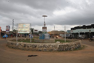
Yumbe is a town in the Northern Region of Uganda. It is the district headquarters of Yumbe District.

Pakwach is a town in the Northern Region of Uganda. It is the main commercial, political and administrative center of Pakwach District. In the 19th century the town came under brief occupation by the Ottoman tributary of the Khedivate of Egypt, as part of Hatt-ı Üstuva (Equatoria) Vilayet.

Koboko is a town in Northern Region of Uganda. It is the main municipal, administrative, and commercial centre of Koboko District. Koboko is also the hometown of former dictator Idi Amin who ruled Uganda from 1971 to 1979.

Nebbi is a town in the Nebbi District of the Northern Region of Uganda. It is the site of the district headquarters.

Atiak is a town in the Northern Region of Uganda on the Gulu-Nimule Road, the primary trade route between Uganda and South Sudan.

Arua Regional Referral Hospital, commonly known as Arua Hospital is a hospital in the town of Arua, in Northern Uganda. It is the referral hospital for the districts of Adjumani, Arua, Koboko, Maracha, Moyo, Nebbi, Yumbe, and Zombo. The hospital also receives referrals from neighboring parts of South Sudan and the Democratic Republic of the Congo.

The Atiak–Adjumani–Moyo–Afonji Road is in the Northern Region of Uganda, connecting the towns of Atiak, Adjumani, Moyo, and Afoji at the international border with South Sudan.

Afoji is a town in Moyo District, in the Northern Region of Uganda.

The Koboko–Yumbe–Moyo Road is a road in the Northern Region of Uganda, connecting the towns of Koboko, Yumbe, and Moyo.

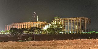
Yumbe Hospital, is a hospital in the West Nile sub-region of the Northern Region of Uganda.

Lodonga is a town in the Northern Region of Uganda. It is one of the municipalities in Yumbe District.

The Atiak–Laropi Road is a road in the Northern Region of Uganda. The road connects the urban centers of Atiak, in Amuru District to Adjumani, in Adjumani District to end in the town of Laropi, in Moyo District.

References

  1. 1 2 3 Uganda Bureau of Statistics (14 June 2020). "The population development of Moyo as well as related information and services" (Citypopulation.de Quoting Uganda Bureau of Statistics). Citypopulatin.de. Retrieved 27 January 2021.
  2. West Nile Web (30 September 2019). "Moyo Town Officials Call For More Funding". Arua, Uganda: West Nile Web. Retrieved 27 January 2021.
  3. Google (27 January 2021). "Distance Between Arua, Uganda And Moyo, Uganda" (Map). Google Maps . Google. Retrieved 27 January 2021.
  4. Google (27 January 2021). "Distance Between Gulu, Northern Region, Uganda And Moyo, Northern Region, Uganda" (Map). Google Maps . Google. Retrieved 27 January 2021.
  5. Google (27 January 2021). "Road Distance Between Kampala, Uganda And Moyo, Uganda" (Map). Google Maps . Google. Retrieved 27 January 2021.
  6. 1 2 Google (27 January 2021). "Location of Moyo Town, Northern Region, Uganda" (Map). Google Maps . Google. Retrieved 27 January 2021.
  7. Floodmap (27 January 2021). "Elevation of Moyo Town, Uganda". Floodmap.net. Retrieved 27 January 2021.
  8. Google (27 January 2021). "Map of Moyo Town Showing Intersection of Koboko–Yumbe–Moyo Road With Atiak–Adjumani–Moyo–Afoji Road" (Map). Google Maps . Google. Retrieved 27 January 2021.