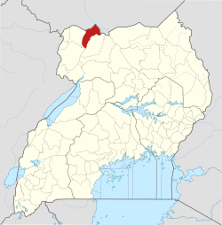
Afoji

Last updated
Afoji
Uganda location map.svg
Red pog.svg
Afoji
Location on the South Sudan–Uganda border
Placement on map is approximate
Coordinates: 03°42′13″N31°40′36″E / 3.70361°N 31.67667°E / 3.70361; 31.67667
CountryFlag of Uganda.svg  Uganda
Region Northern Region of Uganda
Sub-region West Nile sub-region
District Moyo District
Elevation
1,200 m (3,900 ft)

Afoji is a town in Moyo District, in the Northern Region of Uganda.

Contents

Location

Afoji is located at the border with South Sudan, approximately 9 kilometres (6 mi), by road, northwest of the central business district of Moyo Town. [1] This lies approximately 165 kilometres (103 mi) northeast of Arua, the largest urban centre in West Nile sub-region. [2] This is about 496 kilometres (308 mi), by road, northwest of Kampala, Uganda's capital and largest city. [3] The geographical coordinates of Afoji are 03°42'13.0"N, 31°40'36.0"E (Latitude:3.703609; Longitude:31.676658). [4]

Overview

The Atiak–Adjumani–Moyo–Afoji Road, facilitates trade and the movement of people between Uganda and South Sudan. [5] [6]

Related Research Articles

<span class="mw-page-title-main">Adjumani District</span> District in Northern Region, Uganda

Adjumani District is a district in Northern Uganda. Like most other Ugandan districts, it is named after its 'chief town', Adjumani, where the district headquarters are located.

<span class="mw-page-title-main">Moyo District</span> District in Northern Uganda, Uganda

Moyo District is a district in Northern Region of Uganda. Like many other Ugandan districts, it is named after its "chief town", Moyo, where the district headquarters are located.

Arua is a city and commercial centre within the Arua District in the Northern Region of Uganda.

<span class="mw-page-title-main">West Nile sub-region</span>

West Nile sub-region, previously known as West Nile Province and West Nile District, is a sub-region in north-western Uganda, in the Northern Region of Uganda.

<span class="mw-page-title-main">Adjumani</span> Ugandan town

Adjumani is a town in the Northern Region of Uganda. It is the main municipal, administrative, and commercial centre of Adjumani District. The district is named after the town.

Yumbe is a town in the Northern Region of Uganda. It is the district headquarters of Yumbe District.

Moyo, is the main municipal, administrative, and commercial center of Moyo District in the Northern Region of Uganda. The district headquarters are located here.

Pakwach is a town in the Northern Region of Uganda. It is the main commercial, political and administrative center of Pakwach District. In the 19th century the town came under brief occupation by the Ottoman tributary of the Khedivate of Egypt, as part of Hatt-ı Üstuva (Equatoria) Vilayet.

Koboko is a town in Northern Region of Uganda. It is the main municipal, administrative, and commercial centre of Koboko District. Koboko is also the hometown of former dictator Idi Amin who ruled Uganda between 1971 and 1979.

<span class="mw-page-title-main">Paidha</span> Place in Northern Region of Uganda, Uganda

Paidha is a town in the Northern Region of Uganda.

Arua Regional Referral Hospital, commonly known as Arua Hospital is a hospital in the town of Arua, in Northern Uganda. It is the referral hospital for the districts of Adjumani, Arua, Koboko, Maracha, Moyo, Nebbi, Yumbe, and Zombo. The hospital also receives referrals from neighboring parts of South Sudan and the Democratic Republic of the Congo.

Oraba is a town in the Koboko District of the Northern Region of Uganda.

The Atiak–Adjumani–Moyo–Afonji Road is in the Northern Region of Uganda, connecting the towns of Atiak, Adjumani, Moyo, and Afoji at the international border with South Sudan.

The Koboko–Yumbe–Moyo Road is a road in the Northern Region of Uganda, connecting the towns of Koboko, Yumbe, and Moyo.

Adjumani General Hospital, also Adjumani Hospital, is a hospital in Adjumani Town, Adjumani District, in the Northern Region of Uganda. It is a public hospital, owned by the Ugandan Government and is administered by the Uganda Ministry of Health.

Moyo General Hospital also Moyo Hospital, is a hospital in the Northern Region of Uganda.

Maracha is a town in the West Nile sub-region, in Northern Uganda. It is the main municipal, administrative and commercial center of Maracha District and the headquarters of the district are located there. The district is named after the town.

Pakwach District is a district in the Northern Region of Uganda. The town of Pakwach is the location of the district headquarters.

The Lira–Gulu–Nebbi–Arua High Voltage Power Line is a high voltage electricity power line, under construction in Uganda. It connects the high voltage substation at Lira, in Lira District, to another high voltage substation at Arua, in Arua District, all in the Northern Region of the country.

The Kampala–Gulu Highway, also Kampala–Gulu Road, is a road connecting the capital city of Kampala, in the Central Region, with the city of Gulu, the largest urban centre in the Northern Region of Uganda.

References

  1. Google (8 August 2021). "Road Distance Between Moyo Town, Uganda And Afoji Town, Uganda With Interactive Map" (Map). Google Maps . Google. Retrieved 8 August 2021.
  2. Google (8 August 2021). "Road Distance Between Arua, Uganda And Afoji, Uganda With Interactive Map" (Map). Google Maps . Google. Retrieved 8 August 2021.
  3. Google (8 August 2021). "Road Distance between Kampala Road, Kampala, Central Region, Uganda and Afoji Town, Moyo District, Northern Region, Uganda" (Map). Google Maps . Google. Retrieved 8 August 2021.
  4. Google (25 March 2016). "Location of Afoji, Moyo District, Northern Region, Uganda" (Map). Google Maps . Google. Retrieved 25 March 2016.
  5. Ezaruku Draku Franklin, and Ronald Batre (2 September 2009). "Moyo Residents Close Sudan Boarder". Kampala: Uganda Radio Network. Retrieved 25 March 2016.
  6. Okello, Felix Warom (5 March 2012). "Calming tensions: Uganda-Sudan border reopens after 24-hour standoff". Daily Monitor . Kampala. Retrieved March 25, 2016.