The 2003 Colima earthquake occurred on 21 January with a moment magnitude of 7.6 and a maximum Mercalli intensity of VIII (Severe). The epicenter was located on the Pacific coast in the Mexican state of Colima. The earthquake was felt as far away as Mexico City and in southern parts of the United States.
The 1980 Oaxaca earthquake occurred on October 24 at with a moment magnitude of 7.2 and a maximum Mercalli intensity of IX (Violent). This dip-slip shock left up to 300 dead, many injured, and about 150,000 homeless. While it was felt throughout southern Mexico and in Guatemala, damage was focused in the Huajuapan de León region of the state of Oaxaca.

The 1915 Pleasant Valley earthquake occurred at in north-central Nevada. With a moment magnitude of 6.8, a surface wave magnitude of 7.7, and a maximum Mercalli intensity of X (Extreme), it was the strongest earthquake ever recorded in the state.
The 1995 Antofagasta earthquake occurred on July 30 at 05:11 UTC with a moment magnitude of 8.0 and a maximum Mercalli intensity of VII. The Antofagasta Region in Chile was affected by a moderate tsunami, with three people killed, 58 or 59 injured, and around 600 homeless. Total damage from the earthquake and tsunami amounted to $1.791 million.
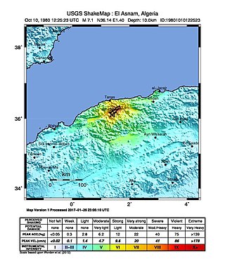
The 1980 El Asnam earthquake occurred on October 10 at with a moment magnitude of 7.1 and a maximum Mercalli intensity of X (Extreme). The shock occurred in the Algerian town of El Asnam. The shocks were felt over 550 km (340 mi) away, with the initial earthquake lasting 35 seconds. It was the largest earthquake in Algeria, and was followed three hours later by a magnitude 6.2 aftershock. The earthquake created about 42 km (26 mi) of surface rupture and had a vertical slip of up to 4.2 m (14 ft). No foreshocks were recorded. The earthquake was found to have occurred very close to the epicenter of the 1954 Chlef earthquake using joint epicenter determination techniques. It occurred at a previously unknown reverse fault.
The 1984 San Pedro Basin earthquake occurred on June 24 at with a moment magnitude of 6.7 and a maximum Mercalli intensity of VII. The event occurred off the southern coast of the Dominican Republic and resulted in an estimated five fatalities.
On 13 March 1992, a moment magnitude 6.7 earthquake struck eastern Turkey. It had a maximum Mercalli intensity of IX (Violent) and occurred along the North Anatolian Fault. At least 498 people died, roughly 2,000 were injured, and an unknown number of people went missing. Total financial losses were between $13.5 million and $750 million.
The 2003 Altai earthquake, or 2003 Chuya earthquake, occurred on September 27 at with a moment magnitude of 7.3 and a maximum Mercalli intensity of X (Extreme). The epicenter of this oblique-slip shock was in Altai Republic, Russia near the borders of Mongolia, China, and Kazakhstan. Three deaths and five injuries were reported and the total damage was listed as $10.6–33 million.

The 1975 Hawaii earthquake occurred on November 29 with a moment magnitude of 7.7 and a maximum Mercalli intensity of VIII (Severe). The shock affected several of the Hawaiian Islands and resulted in the deaths of two people and up to 28 injured. Significant damage occurred in the southern part of the Big Island totalling $4–4.1 million, and it also triggered a small brief eruption of Kilauea volcano.
The 1954 Chlef earthquake struck El Asnam Province in French Algeria on 9 September at . The shock measured 6.7 on the moment magnitude scale and had a maximum Mercalli intensity of XI (Extreme). It destroyed Chlef, then named Orléansville, leaving over 1,243 people dead and 5,000 injured. Damage was estimated at $6 million. It was followed by multiple aftershocks. Algeria faces annual earthquakes and has undergone several changes to its earthquake building codes since its first earthquake engineering regulations from 1717.
The 1999 Aïn Témouchent earthquake occurred on December 22 at in northern Algeria. The dip-slip event had a moment magnitude of 5.6 and a maximum Mercalli intensity of VII. At least 22 were killed, 175 were injured, and 15,000–25,000 were made homeless. The Belgian Centre for Research on the Epidemiology of Disasters' EM-DAT database and the USGS' National Geophysical Data Center both list financial losses of $60.93 million.
The 1976 Sabah earthquake occurred at 10:56 am on 26 July near Lahad Datu in the eastern portion of Sabah, Malaysia. The moment magnitude 6.3 earthquake is one of the strongest in Malaysia to be recorded by seismic instruments. It had a focal mechanism corresponding to strike-slip faulting. While slightly larger than the 2015 Sabah earthquake, the 1976 event caused less extensive damage, in the form of cracks on several buildings and ground cracks.

The 1918 San Jacinto earthquake occurred in extreme eastern San Diego County in Southern California on April 21 at . The shock had a moment magnitude of 6.7 and a maximum Mercalli intensity of IX (Violent). Several injuries and one death occurred with total losses estimated to be $200,000.
The 1990 Upland earthquake occurred at on February 28 with a moment magnitude of 5.7 and a maximum Mercalli Intensity of VII. This left-lateral strike-slip earthquake occurred west of the San Andreas Fault System and injured thirty people, with total losses of $12.7 million. Many strong motion instruments captured the event, with an unexpectedly high value seen on water tank near the epicentral area.

The Western Australian town of Meckering was struck by an earthquake on 14 October 1968. The earthquake occurred at , with a moment magnitude of 6.5 and a maximum Mercalli intensity of IX (Violent). Total damage amounted to $2.2 million with 20–28 injured.
The 1981 Golbaf earthquake occurred on June 11 at with a moment magnitude of 6.6 and a maximum Mercalli intensity of VIII+ (Severe). Total damage was considered moderate and amounted to $5 million in financial losses, with many injured and 3,000 killed.
The 2004 Baladeh earthquake occurred on May 28 in northern Iran. This dip-slip earthquake had a moment magnitude of 6.3 and a maximum Mercalli intensity of VIII (Severe). Total deaths for the event amounted to 35, with 278–400 injured, and $15.4 million in damage.
The 1974 Lesser Antilles earthquake occurred at on October 8 with a moment magnitude of 6.9 and a maximum Mercalli intensity of VIII (Severe). Four people were injured in what the United States' National Geophysical Data Center called a moderately destructive event.
