Deep-focus earthquake

Last updated
Seismicity cross-section across part of the Kuril Islands subduction zone. Many deep earthquakes have occurred. Kuril Benioff zone.JPG
Seismicity cross-section across part of the Kuril Islands subduction zone. Many deep earthquakes have occurred.

A deep-focus earthquake in seismology (also called a plutonic earthquake) is an earthquake with a hypocenter depth exceeding 300 km. They occur almost exclusively at convergent boundaries in association with subducted oceanic lithosphere. They occur along a dipping tabular zone beneath the subduction zone known as the Wadati–Benioff zone. [1]

Contents

Discovery

Preliminary evidence for the existence of deep-focus earthquakes was first brought to the attention of the scientific community in 1922 by Herbert Hall Turner. [2] In 1928, Kiyoo Wadati proved the existence of earthquakes occurring well beneath the lithosphere, dispelling the notion that earthquakes occur only with shallow focal depths. [3]

Seismic characteristics

Deep-focus earthquakes give rise to minimal surface waves. [3] Their focal depth causes the earthquakes to be less likely to produce seismic wave motion with energy concentrated at the surface. The path of deep-focus earthquake seismic waves from focus to recording station goes through the heterogeneous upper mantle and highly variable crust only once. [3] Therefore, the body waves undergo less attenuation and reverberation than seismic waves from shallow earthquakes, resulting in sharp body wave peaks.

Focal mechanisms

The pattern of energy radiation of an earthquake is represented by the moment tensor solution, which is graphically represented by beachball diagrams. An explosive or implosive mechanism produces an isotropic seismic source. Slip on a planar fault surface results in a double-couple source. Uniform outward motion in a single plane due to normal shortening is known as a compensated linear vector dipole source. [3] Deep-focus earthquakes have been shown to contain a combination of these sources. The focal mechanisms of deep-focus earthquakes depend on their positions in subducting tectonic plates. At depths greater than 400 km, down-dip compression dominates, while at depths of 250-300 km (also corresponding to a minimum in earthquake numbers vs. depth), the stress regime is more ambiguous but closer to down-dip tension. [4] [5]

Physical process

Shallow-focus earthquakes are the result of the sudden release of strain energy built up over time in rock by brittle fracture and frictional slip over planar surfaces. [6] However, the physical mechanism of deep focus earthquakes is poorly understood. Subducted lithosphere subject to the pressure and temperature regime at depths greater than 300 km should not exhibit brittle behavior, but should rather respond to stress by plastic deformation. [3] Several physical mechanisms have been proposed for the nucleation and propagation of deep-focus earthquakes; however, the exact process remains an outstanding problem in the field of deep-earth seismology.

The following four subsections outline proposals which could explain the physical mechanism allowing deep focus earthquakes to occur. With the exception of solid-solid phase transitions, the proposed theories for the focal mechanism of deep earthquakes hold equal footing in current scientific literature.

Solid-solid phase transitions

The earliest proposed mechanism for the generation of deep-focus earthquakes is an implosion due to a phase transition of material to a higher-density, lower-volume phase. [3] The olivine-spinel phase transition is thought to occur at a depth of 410 km in the interior of the earth. This hypothesis proposes that metastable olivine in oceanic lithosphere subducted to depths greater than 410 km undergoes a sudden phase transition to spinel structure. The increase in density due to the reaction would cause an implosion giving rise to the earthquake. This mechanism has been largely discredited due to the lack of a significant isotropic signature in the moment tensor solution of deep-focus earthquakes. [1]

Dehydration embrittlement

Dehydration reactions of mineral phases with high water content would increase the pore pressure in a subducted oceanic lithosphere slab. This effect reduces the effective normal stress in the slab and allows slip to occur on pre-existing fault planes at significantly greater depths than would normally be possible. [1] Several workers[ who? ] suggest that this mechanism does not play a significant role in seismic activity beyond 350 km depth due to the fact that most dehydration reactions will have reached completion by a pressure corresponding to depths of 150-300 km (5-10 GPa). [1]

Transformational faulting or anticrack faulting

Transformational faulting, also known as anticrack faulting, is the result of the phase transition of a mineral to a higher-density phase occurring in response to shear stress in a fine-grained shear zone. The transformation occurs along the plane of maximal shear stress. Rapid shearing can then occur along these planes of weakness, giving rise to an earthquake in a mechanism similar to a shallow-focus earthquake. Metastable olivine subducted past the olivine-wadsleyite transition at 320-410 km depth (depending on temperature) is a potential candidate for such instabilities. [3] Arguments against this hypothesis include the requirements that the faulting region should be very cold, and contain very little mineral-bound hydroxyl. Higher temperatures or higher hydroxyl contents preclude the metastable preservation of olivine to the depths of the deepest earthquakes.

Shear instability / thermal runaway

A shear instability arises when heat is produced by plastic deformation faster than it can be conducted away. The result is thermal runaway, a positive feedback loop of heating, material weakening, and strain localisation within the shear zone. [3] Continued weakening may result in partial melting along zones of maximal shear stress. Plastic shear instabilities leading to earthquakes have not been documented in nature, nor have they been observed in natural materials in the laboratory. Their relevance to deep earthquakes therefore lies in mathematical models which use simplified material properties and rheologies to simulate natural conditions.

Deep-focus earthquake zones

Major zones

Eastern Asia / Western Pacific

On the border of the Pacific Plate and the Okhotsk and Philippine Sea Plates is one of the most active deep-focus earthquake regions in the world, creating many large earthquakes including the Mw 8.3 2013 Okhotsk Sea earthquake. As with many places, earthquakes in this region are caused by internal stresses on the subducted Pacific Plate as it is pushed deeper into the mantle.

Philippines

A subduction zone makes up most of the border of Philippine Sea Plate and Sunda Plate, the fault being partially responsible for the uplift of the Philippines. The deepest sections of the Philippine Sea Plate cause earthquakes as deep as 675 kilometres (419 mi) below the surface. [7] Notable deep-focus earthquakes in this region include a Mw 7.7 earthquake in 1972 and the Mw 7.6, 7.5, and 7.3 2010 Mindanao earthquakes.

Indonesia

The Australian Plate subducts under the Sunda Plate, creating uplift over much of southern Indonesia, as well as earthquakes at depths of up to 675 kilometres (419 mi). [8] Notable deep-focus earthquakes in this region include a Mw 7.9 earthquake in 1996 and a Mw 7.5 earthquake in 2007.

Papua New Guinea / Fiji / New Zealand

By far the most active deep focus faulting zone in the world is that caused by the Pacific Plate subducting under the Australian Plate, Tonga Plate, and Kermadec Plate. Earthquakes have been recorded at depths of over 735 kilometres (457 mi), [9] the deepest in the planet. The large area of subduction results in a broad swath of deep-focus earthquakes centered from Papua New Guinea to Fiji to New Zealand, although the angle of the plates' collision causes the area between Fiji and New Zealand to be the most active, with earthquakes of Mw 4.0 or above occurring on an almost daily basis. [10] Notable deep-focus earthquakes in this region include a Mw 8.2 and 7.9 earthquake in 2018, and a Mw 7.8 earthquake in 1919.

Andes

The subduction of the Nazca Plate under the South American Plate, in addition to creating the Andes mountain range, has also created a number of deep faults under the surfaces of Colombia, Peru, Brazil, Bolivia, Argentina, and even as far east as Paraguay. [11] Earthquakes frequently occur in the region at depths of up to 670 kilometres (420 mi) beneath the surface. [12] Several large earthquakes have taken place here, including the Mw 8.2 1994 Bolivia earthquake (631 km deep), the Mw 8.0 1970 Colombia earthquake (645 km deep), and Mw 7.9 1922 Peru earthquake (475 km deep).

Minor zones

Granada, Spain

Roughly 600–630 kilometres (370–390 mi) under the city Granada in southern Spain, several large earthquakes have been recorded in modern history, notably including a Mw 7.8 earthquake in 1954, [13] and a Mw 6.3 earthquake in 2010. As Spain is not near any known subduction zones, the exact cause for the earthquakes remains unknown. [14]

Tyrrhenian Sea

The Tyrrhenian Sea west of Italy is host to a large number of deep-focus earthquakes as deep as 520 kilometres (320 mi) below the surface. [15] However, very few earthquakes occur in the region less than 100 kilometres (62 mi) deep, the majority originating from a depth of around 250–300 kilometres (160–190 mi). Due to the lack of shallow earthquakes, the faulting is believed to originate from an ancient subduction zone that began subducting less than 15 million years ago, and largely finished around 10 million years ago, no longer visible on the surface. [16] Due to the calculated subduction rate, the cause for subduction was likely to be internal stressing on the Eurasian Plate, rather than due to the collision of the African and Eurasian Plates, the cause of modern-day subduction for the nearby Aegean Sea and Anatolian microplates.

Afghanistan

In northeastern Afghanistan, a number of medium-intensity deep focus earthquakes of depths of up to 400 kilometres (250 mi) occasionally occur. [17] They are caused by the collision and subduction of the Indian Plate under the Eurasian Plate, the deepest earthquakes centered on the furthest-subducted sections of the plate. [18]

South Sandwich Islands

The South Sandwich Islands between South America and Antarctica are host to a number of earthquakes up to 320 kilometres (200 mi) in depth. [19] They are caused by the subduction of the South American Plate under the South Sandwich Plate. [20]

Notable deep-focus earthquakes

The strongest deep-focus earthquake in seismic record was the magnitude 8.3 Okhotsk Sea earthquake that occurred at a depth of 609 km in 2013. [21] The deepest earthquake ever recorded was a small 4.2 earthquake in Vanuatu at a depth of 735.8 km in 2004. [22] However, although unconfirmed, an aftershock of the 2015 Ogasawara earthquake was found to have occurred at a depth of 751 km. [23]

Related Research Articles

<span class="mw-page-title-main">Oceanic trench</span> Long and narrow depressions of the sea floor

Oceanic trenches are prominent, long, narrow topographic depressions of the ocean floor. They are typically 50 to 100 kilometers wide and 3 to 4 km below the level of the surrounding oceanic floor, but can be thousands of kilometers in length. There are about 50,000 km (31,000 mi) of oceanic trenches worldwide, mostly around the Pacific Ocean, but also in the eastern Indian Ocean and a few other locations. The greatest ocean depth measured is in the Challenger Deep of the Mariana Trench, at a depth of 10,920 m (35,830 ft) below sea level.

<span class="mw-page-title-main">Subduction</span> A geological process at convergent tectonic plate boundaries where one plate moves under the other

Subduction is a geological process in which the oceanic lithosphere and some continental lithosphere is recycled into the Earth's mantle at convergent boundaries. Where the oceanic lithosphere of a tectonic plate converges with the less dense lithosphere of a second plate, the heavier plate dives beneath the second plate and sinks into the mantle. A region where this process occurs is known as a subduction zone, and its surface expression is known as an arc-trench complex. The process of subduction has created most of the Earth's continental crust. Rates of subduction are typically measured in centimeters per year, with rates of convergence as high as 11 cm/year.

<span class="mw-page-title-main">Transform fault</span> Plate boundary where the motion is predominantly horizontal

A transform fault or transform boundary, is a fault along a plate boundary where the motion is predominantly horizontal. It ends abruptly where it connects to another plate boundary, either another transform, a spreading ridge, or a subduction zone. A transform fault is a special case of a strike-slip fault that also forms a plate boundary.

<span class="mw-page-title-main">Convergent boundary</span> Region of active deformation between colliding tectonic plates

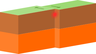
A convergent boundary is an area on Earth where two or more lithospheric plates collide. One plate eventually slides beneath the other, a process known as subduction. The subduction zone can be defined by a plane where many earthquakes occur, called the Wadati–Benioff zone. These collisions happen on scales of millions to tens of millions of years and can lead to volcanism, earthquakes, orogenesis, destruction of lithosphere, and deformation. Convergent boundaries occur between oceanic-oceanic lithosphere, oceanic-continental lithosphere, and continental-continental lithosphere. The geologic features related to convergent boundaries vary depending on crust types.

<span class="mw-page-title-main">Juan de Fuca Plate</span> Small tectonic plate in the eastern North Pacific

The Juan de Fuca Plate is a small tectonic plate (microplate) generated from the Juan de Fuca Ridge that is subducting beneath the northerly portion of the western side of the North American Plate at the Cascadia subduction zone. It is named after the explorer of the same name. One of the smallest of Earth's tectonic plates, the Juan de Fuca Plate is a remnant part of the once-vast Farallon Plate, which is now largely subducted underneath the North American Plate.

The Peru–Chile Trench, also known as the Atacama Trench, is an oceanic trench in the eastern Pacific Ocean, about 160 kilometres (99 mi) off the coast of Peru and Chile. It reaches a maximum depth of 8,065 m (26,460 ft) below sea level in Richards Deep and is approximately 5,900 km (3,666 mi) long; its mean width is 64 km (40 mi) and it covers an expanse of some 590,000 km2 (230,000 sq mi).

<span class="mw-page-title-main">Earth's mantle</span> A layer of silicate rock between Earths crust and its outer core

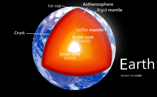
Earth's mantle is a layer of silicate rock between the crust and the outer core. It has a mass of 4.01×1024 kg (8.84×1024 lb) and thus makes up 67% of the mass of Earth. It has a thickness of 2,900 kilometers (1,800 mi) making up about 46% of Earth's radius and 84% of Earth's volume. It is predominantly solid but, on geologic time scales, it behaves as a viscous fluid, sometimes described as having the consistency of caramel. Partial melting of the mantle at mid-ocean ridges produces oceanic crust, and partial melting of the mantle at subduction zones produces continental crust.

<span class="mw-page-title-main">Puerto Rico Trench</span> Oceanic trench on a transform boundary between the Caribbean and North American Plates

The Puerto Rico Trench is located on the boundary between the Caribbean Sea and the Atlantic Ocean. The oceanic trench, the deepest in the Atlantic, is associated with a complex transition between the Lesser Antilles subduction zone to the south and the major transform fault zone or plate boundary, which extends west between Cuba and Hispaniola through the Cayman Trough to the coast of Central America.

<span class="mw-page-title-main">Ryukyu Trench</span> Oceanic trench along the southeastern edge of Japans Ryukyu Islands in the Pacific Ocean

The Ryukyu Trench, also called Nansei-Shotō Trench, is a 1398 km (868 mi) long oceanic trench located along the southeastern edge of Japan's Ryukyu Islands in the Philippine Sea in the Pacific Ocean, between northeastern Taiwan and southern Japan. The trench has a maximum depth of 7460 m (24,476 ft). The trench is the result of oceanic crust of the Philippine Plate obliquely subducting beneath the continental crust of the Eurasian Plate at a rate of approximately 52 mm/yr. In conjunction with the adjacent Nankai Trough to the northeast, subduction of the Philippine plate has produced 34 volcanoes. The largest earthquake to have been recorded along the Ryukyu Trench, the 1968 Hyūga-nada earthquake, was magnitude 7.5 and occurred along the northernmost part of the trench on 1 April 1968. This earthquake also produced a tsunami.

<span class="mw-page-title-main">Wadati–Benioff zone</span> Planar zone of seismicity corresponding with the down-going slab

A Wadati–Benioff zone is a planar zone of seismicity corresponding with the down-going slab in a subduction zone. Differential motion along the zone produces numerous earthquakes, the foci of which may be as deep as about 670 km (420 mi). The term was named for the two seismologists, Hugo Benioff of the California Institute of Technology and Kiyoo Wadati of the Japan Meteorological Agency, who independently discovered the zones.

A slow earthquake is a discontinuous, earthquake-like event that releases energy over a period of hours to months, rather than the seconds to minutes characteristic of a typical earthquake. First detected using long term strain measurements, most slow earthquakes now appear to be accompanied by fluid flow and related tremor, which can be detected and approximately located using seismometer data filtered appropriately. That is, they are quiet compared to a regular earthquake, but not "silent" as described in the past.

The Beijing Anomaly is an observed seismic feature in the Earth's mantle at a depth of around 700–1400 km below Northeastern China where a high degree of seismic attenuation was discovered to exist. According to its discoverers, Jesse Lawrence and Michael Wysession, the Beijing Anomaly is evidence for large amounts of water contained within the mantle.

<span class="mw-page-title-main">Izu–Bonin–Mariana Arc</span> Convergent boundary in Micronesia

The Izu–Bonin–Mariana (IBM) arc system is a tectonic plate convergent boundary in Micronesia. The IBM arc system extends over 2800 km south from Tokyo, Japan, to beyond Guam, and includes the Izu Islands, the Bonin Islands, and the Mariana Islands; much more of the IBM arc system is submerged below sealevel. The IBM arc system lies along the eastern margin of the Philippine Sea Plate in the Western Pacific Ocean. It is the site of the deepest gash in Earth's solid surface, the Challenger Deep in the Mariana Trench.

<span class="mw-page-title-main">Hellenic Trench</span> Long narrow depression bordering the Aegean Sea to the south

The Hellenic Trench (HT) is an oceanic trough located in the forearc of the Hellenic Arc, an arcuate archipelago on the southern margin of the Aegean Sea Plate, or Aegean Plate, also called Aegea, the basement of the Aegean Sea. The HT begins in the Ionian Sea near the mouth of the Gulf of Corinth and curves to the south, following the margin of the Aegean Sea. It passes close to the south shore of Crete and ends near the island of Rhodes just offshore Anatolia.

In seismology, the depth of focus or focal depth is the depth at which an earthquake occurs. Earthquakes occurring at a depth of less than 70 km (43 mi) are classified as shallow-focus earthquakes, while those with a focal depth between 70 km (43 mi) and 300 km (190 mi) are commonly termed mid-focus or intermediate-depth earthquakes. In subduction zones, where older and colder oceanic crust sinks under another tectonic plate, deep-focus earthquakes may occur at much greater depths in the mantle, ranging from 300 km (190 mi) up to 700 km (430 mi).

<span class="mw-page-title-main">2021 Chignik earthquake</span> 7th largest earthquake in the US

An earthquake occurred off the coast of the Alaska Peninsula on July 28, 2021, at 10:15 p.m. local time. The large megathrust earthquake had a moment magnitude of 8.2 according to the United States Geological Survey (USGS). A tsunami warning was issued by the National Oceanic and Atmospheric Administration (NOAA) but later cancelled. The mainshock was followed by a number of aftershocks, including three that were of magnitude 5.9, 6.1 and 6.9 respectively.

The 2021 Loyalty Islands earthquake was a 7.7 magnitude earthquake that struck offshore between Vanuatu and New Caledonia on February 11, 2021 at 00:19 local time. It is the 4th largest earthquake of 2021.

The 2021 South Sandwich Islands earthquakes were a pair of powerful earthquakes, followed by many strong aftershocks which struck along the South Sandwich Trench in August 2021. The quakes measured 7.5 and 8.1 on the moment magnitude scale, according to the United States Geological Survey. The mainshock is tied with another event in 1929 as the largest earthquake ever recorded in this region, and is tied with the 2021 Kermadec Islands earthquake as the second largest earthquake of 2021.

The 2016 Alborian Sea earthquake struck offshore, north northeast of Al Hoceïma, Morocco in the Strait of Gibraltar on January 25 at 04:22:02 UTC, or roughly 05:22:02 West Africa Time. At its strongest in the Alboran Sea, the earthquake measured 6.3–6.4 on the moment magnitude scale (Mw ) at a shallow hypocenter depth of 12 km (7.5 mi). Assigned a maximum Modified Mercalli scale intensity of VI (Strong), the earthquake caused one fatality, injuries to at least 30 persons, and moderate damage in Morocco and Spain.

<span class="mw-page-title-main">Chile Ridge</span> Submarine oceanic ridge in the Pacific Ocean

The Chile Ridge, also known as the Chile Rise, is a submarine oceanic ridge formed by the divergent plate boundary between the Nazca Plate and the Antarctic Plate. It extends from the triple junction of the Nazca, Pacific, and Antarctic plates to the Southern coast of Chile. The Chile Ridge is easy to recognize on the map, as the ridge is divided into several segmented fracture zones which are perpendicular to the ridge segments, showing an orthogonal shape toward the spreading direction. The total length of the ridge segments is about 550–600 km.

References

  1. 1 2 3 4 Frolich, Cliff (1989). "The Nature of Deep-Focus Earthquakes". Annual Review of Earth and Planetary Sciences. 17: 227–254. Bibcode:1989AREPS..17..227F. doi:10.1146/annurev.ea.17.050189.001303.
  2. Green, Harry W. (995). "The mechanics of deep earthquakes". Annual Review of Earth and Planetary Sciences. 23: 169. doi:10.1146/annurev.earth.23.1.169.
  3. 1 2 3 4 5 6 7 8 Frohlich, Cliff (2006). Deep Earthquakes. Cambridge University Press. ISBN   978-0-521-82869-7.[ page needed ]
  4. Isacks, Bryan; Molnar, Peter (September 1969). "Mantle Earthquake Mechanisms and the Sinking of the Lithosphere". Nature. 223 (5211): 1121–1124. Bibcode:1969Natur.223.1121I. doi:10.1038/2231121a0. S2CID   4206932.
  5. Vassiliou, M.S. (July 1984). "The state of stress in subducting slabs as revealed by earthquakes analysed by moment tensor inversion". Earth and Planetary Science Letters. 69 (1): 195–202. Bibcode:1984E&PSL..69..195V. doi:10.1016/0012-821X(84)90083-9.
  6. Kearey, Philip; Keith A. Klepeis; Frederick J. Vine (2013). Global Tectonics (3 ed.). John Wiley & Sons. ISBN   978-1-118-68808-3.[ page needed ]
  7. "M 4.8 - Celebes Sea". earthquake.usgs.gov. Retrieved 26 December 2019.
  8. "M 4.6 - Banda Sea". earthquake.usgs.gov. Retrieved 26 December 2019.
  9. "M 4.2 - Vanuatu region". earthquake.usgs.gov. Retrieved 26 December 2019.
  10. "Latest Earthquakes". earthquake.usgs.gov. Retrieved 26 December 2019.
  11. Hayes, Gavin P.; Smoczyk, Gregory M.; Benz, Harley M.; Furlong, Kevin P.; Villaseñor, Antonio (2015). "Seismicity of the Earth 1900-2013, seismotectonics of South America (Nazca Plate Region)". Open-File Report. doi:10.3133/ofr20151031E.
  12. "M 3.7 - Acre, Brazil". earthquake.usgs.gov. Retrieved 26 December 2019.
  13. "M 7.8 - Strait of Gibraltar". earthquake.usgs.gov. Retrieved 26 December 2019.
  14. "An Enigma Deep Beneath Spain". seismo.berkeley.edu. Retrieved 26 December 2019.
  15. "M 3.7 - Tyrrhenian Sea". earthquake.usgs.gov. Retrieved 26 December 2019.
  16. Anderson, H.; Jackson, J. (1 December 1987). "The deep seismicity of the Tyrrhenian Sea". Geophysical Journal International. 91 (3): 613–637. Bibcode:1987GeoJ...91..613A. doi: 10.1111/j.1365-246X.1987.tb01661.x .
  17. "M 5.0 - 4km SSE of Ashkasham, Afghanistan". earthquake.usgs.gov. Retrieved 26 December 2019.
  18. "Cause of Afghan Quake Is a Deep Mystery". National Geographic News. 26 October 2015. Retrieved 26 December 2019.
  19. "M 4.3 - 132km NNW of Bristol Island, South Sandwich Islands". earthquake.usgs.gov. Retrieved 26 December 2019.
  20. Vanneste, Lieve E.; Larter, Robert D. (July 2002). "Sediment subduction, subduction erosion, and strain regime in the northern South Sandwich forearc". Journal of Geophysical Research: Solid Earth. 107 (B7): EPM 5-1–EPM 5-24. Bibcode:2002JGRB..107.2149V. doi: 10.1029/2001JB000396 .
  21. "M8.3 - Sea of Okhotsk". USGS. 2013-05-25. Retrieved 2013-05-25.
  22. "M 4.2 - Vanuatu region". earthquake.usgs.gov. Retrieved 2018-01-22.
  23. "Deepest earthquake ever detected struck 467 miles beneath Japan". National Geographic. October 26, 2021. Retrieved January 13, 2022.