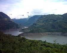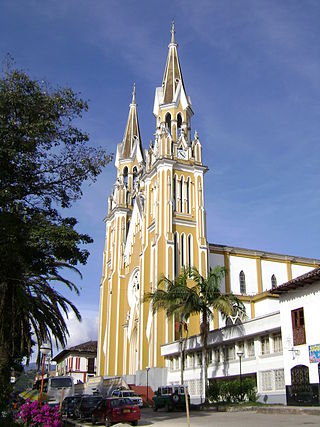
Garagoa is a town and municipality in Colombia, located in the Boyacá Department. It covers an area of 191.75 km2 and the urban centre is located at an altitude of 1,650 metres (5,410 ft) above sea level. Parts of the municipality reach altitudes of 3,050 metres (10,010 ft). It is the capital of the province of Neira. It is also the seat of the Diocese of Garagoa of the Catholic Church. The municipality is situated in the Eastern Ranges of the Colombian Andes and borders Chinavita in the north, Macanal in the south, Tenza and Sutatenza in the west and Miraflores and Chinavita in the east.

Duitama is a city and municipality in the department of Boyacá. It's the capital of the Tundama Province. Duitama is located 195 kilometres (121 mi) northeast of Bogotá, the capital of Colombia and 50 kilometres (31 mi) northeast of Tunja, the capital of Boyacá. In 2023 Duitama had an estimated population of 131,591.

Sogamoso is a city in the department of Boyacá of Colombia. It is the capital of the Sugamuxi Province, named after the original Sugamuxi. Sogamoso is nicknamed "City of the Sun", based on the original Muisca tradition of pilgrimage and adoring their Sun god Sué at the Sun Temple. The city is located at an altitude of 2,569 metres (8,428 ft) on the Altiplano Cundiboyacense in the Eastern Ranges of the Colombian Andes.

Almeida is a town and municipality in Boyacá Department, Colombia, part of the province of the Eastern Boyacá Province.

Boyacá is a town and municipality in the Márquez Province, part of the department of Boyacá, Colombia. It is located approximately 15 kilometres (9.3 mi) from the city of Tunja, the capital of the department. Boyacá limits Tunja and Soracá in the north, Jenesano in the south, Nuevo Colón and Ramiriquí in the west and Ventaquemada in the east.

Chiquinquirá is a town and municipality in the Colombian Department of Boyacá, part of the subregion of the Western Boyacá Province. Located some 115 km north of Bogotá, Chiquinquirá is situated 2,556 metres (8,386 ft) above sea level and has a yearly average temperature 58 °F (14 °C)

Cucaita is a municipality in the Central Boyacá Province, part of Boyacá Department, Colombia. The urban centre is situated on the Altiplano Cundiboyacense at a distance of 20 kilometres (12 mi) from the department capital Tunja. Cucaita borders Sora in the north, Tunja in the east and south and Samacá in the south and west.
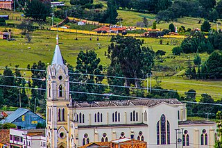
Cómbita is a town and municipality in the Colombian Department of Boyacá, part of the sub region of the Central Boyacá Province. Cómbita is situated on the Altiplano Cundiboyacense and borders Arcabuco and the department of Santander in the north, Sotaquirá in the northeast, Tuta and Oicatá in the east, department capital Tunja at 8.5 kilometres (5.3 mi) away and Motavita in the south and Arcabuco and Motavita in the west.

Chivor is a town and municipality in the Eastern Boyacá Province, part of the Colombian department of Boyacá. The mean temperature of the village in the Tenza Valley is 18 °C (64 °F) and Chivor is located at 215 kilometres (134 mi) from the department capital Tunja. Economic activity includes emerald mining.

Guayatá is a town and municipality in the Eastern Boyacá Province, part of the Colombian department of Boyacá. Guayatá is situated on the Altiplano Cundiboyacense at distances of 129 kilometres (80 mi) from the department capital Tunja and 132 kilometres (82 mi) from the national capital Bogotá. The urban centre is located at an altitude of 1,767 metres (5,797 ft) and the altitude ranges from 1,270 metres (4,170 ft) to 3,080 metres (10,100 ft).

Zetaquirá is a town and municipality in the Colombian Lengupá Province, part of the department of Boyacá. Zetaquirá is located at 67 kilometres (42 mi) from the department capital Tunja and borders Pesca in the north, Miraflores in the south, in the east Berbeo, San Eduardo and Aquitania and in the west Ramiriquí and Chinavita. The municipality stretches over an area of 262 square kilometres (101 sq mi) on the Altiplano Cundiboyacense at altitudes between 1,875 metres (6,152 ft) and 3,600 metres (11,800 ft).

Turmequé is a town and municipality in the Colombian Department of Boyacá, part of the subregion of the Márquez Province. Turmequé is located at 105 kilometres (65 mi) northeast from the capital Bogotá. The municipality borders Ventaquemada in the west, in the east Úmbita, in the north Nuevo Colón and in the south the municipality Villapinzón of the department of Cundinamarca.

Sáchica is a municipality of Colombia situated approximately 34 km (21 mi) west of Tunja in the Ricaurte Province of the department of Boyacá. Sáchica borders Sutamarchán and Villa de Leyva in the north, in the east Chíquiza, Samacá and Ráquira in the south and in the west Ráquira and Sutamarchán.

Manta is a municipality and town located in the northeast of the department of Cundinamarca (Colombia), 90 kilometres (56 mi) from Bogotá. It is located in the Almeidas Province in the Tenza Valley. Manta borders to the north Tibiritá, to the west Machetá, to the south Gachetá and to the east Guateque and Guayatá of the department of Boyacá.

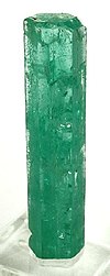
Emeralds are green and sometime green with a blueish-tint precious gemstones that are mined in various geological settings. They are minerals in the beryl group of silicates. For more than 4,000 years, emeralds have been among the most valuable of all jewels. Colombia, located in northern South America, is the country that mines and produces the most emeralds for the global market, as well as the most desirable. It is estimated that Colombia accounts for 70–90% of the world's emerald market. While commercial grade emeralds are quite plentiful, fine and extra fine quality emeralds are extremely rare. Colombian emeralds over 50 carat can cost much more than diamonds of the same size.

The Hunzahúa Well is an archeological site of the Muisca located in the city of Tunja, Boyacá, which in the time of the Muisca Confederation was called Hunza. The well is named after the first zaque of Hunza, Hunzahúa. The well was called Pozo de Donato for a while, after 17th century Jerónimo Donato de Rojas. The well is located on the campus of the Pedagogical and Technological University of Colombia in Tunja. Scholar Javier Ocampo López has written about the well and its mythology. Knowledge about the well has been provided by scholar Pedro Simón.

The Tegua or Tecua were an Arawak-speaking indigenous people of Colombia who died out in the 19th century.

Lake Fúquene is a heart-shaped lake located in the Ubaté-Chiquinquirá Valley, part of the Altiplano Cundiboyacense, in the north of Cundinamarca, Colombia, at the border with Boyacá. The Andean lake, at an average altitude of 2,540 metres (8,330 ft), was considered sacred in the religion of the Muisca who inhabited the area before the Spanish conquest of the Muisca in the 1530s.

The Goranchacha Temple is an archeological site of the Muisca located in the city of Tunja, Boyacá, which in the time of the Muisca Confederation was called Hunza. The temple is named after the mythological Goranchacha. The remains of the temple are located on the terrain of the Pedagogical and Technological University of Colombia in Tunja. Scholar Javier Ocampo López has written about the temple and its religious meaning. Knowledge about the temple has been provided by chronicler Pedro Simón.
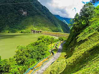
The Tenza Valley is an intermontane valley in the Eastern Ranges of the Colombian Andes. The valley stretches over the southeastern part of the department of Boyacá and the northeastern part of Cundinamarca. It is located east of the Altiplano Cundiboyacense and in the time before the Spanish conquest of the Muisca, as the Altiplano was inhabited by the Muisca in the higher altitudes and the Tegua in the lower areas to the east.


