
Cartago is a city in southwestern Colombia, about 187 miles west of Bogotá. It is in the extreme northern portion of the Valle del Cauca Department. It is located very close to the city of Pereira, about a 20-minute drive. It is the fourth largest city in Valle after Cali, Palmira, and Tuluá. In 2019, it had a population of approximately 135,000 inhabitants.

Quibdó is the capital city of Chocó Department, in Western Colombia, and is located on the Atrato River. The municipality of Quibdó has an area of 3,337.5 km² and a population of 129,237, predominantly Afro Colombian and Zambo Colombians.

The Meta River is a major left tributary of the Orinoco River in eastern Colombia and southern Venezuela, South America. The Meta originates in the Eastern Ranges of the Andes and flows through the Meta Department, Colombia as the confluence of the Humea, Guatiquía and Guayuriba rivers. It flows east-northeastward across the Llanos Orientales of Colombia following the direction of the Meta Fault. The Meta forms the northern boundary of Vichada Department, first with Casanare Department, then with Arauca Department, and finally with Venezuela, down to Puerto Carreño where it flows into the Orinoco.

The Nevado del Quindío is an inactive volcano located in the Central Cordillera of the Andes in central Colombia. The summit marks the tripoint of the departments of Risaralda, Quindío and Tolima, and is also the highest point of the departments of Risaralda and Quindío. The mountain is one of the highest peaks in the Los Nevados National Natural Park, which is a wildlife sanctuary. There are no historical records of any eruption. The andesitic volcano is located on top of the Palestina Fault.

The Guahibo people are an indigenous people native to the Llanos or savanna plains in eastern Colombia and in southern Venezuela near the Colombian border. Their population was estimated at 23,772 people in 1998.

Lloró is a municipality and town in the Chocó Department, Colombia. It claims the second world record for highest average annual precipitation with 12,717 mm (501 in), after López de Micay, which holds an also disputed record with 12,892.4 mm (508 in). The official record is held by Mawsynram, India. The rainfall data was measured in its Agricultural Farm, managed by the University of Bogotá, between 1952 and 1989. If accurate, that would make it the wettest place in the world. The town is named for Gioró, a pre-Columbian indigenous chief.

San José del Palmar is a municipality and town in the Chocó Department, Colombia in the central part of the country, 240 km west of the capital Bogotá. San José del Palmar is 1,288 meters above sea level and the population is about 4,800.

An 1853 watercolor by Manuel María Paz showing a house in Sipí, built on a raised platform with a notched treetrunk for steps, is held by the National Library of Colombia.

Paz de Ariporo is a town and municipality in the Department of Casanare, Colombia.

Güicán is a town and municipality in the Colombian Department of Boyacá. It is close to the national natural park El Cocuy National Park.

Puracé is a town and municipality in the Cauca Department, Colombia.
Pan de yuca is a type of bread made of cassava starch and cheese typical of western Ecuador and southern Colombia
Saliba is an indigenous language of Eastern Colombia and Venezuela. Saliba was used by Jesuit missionaries in the 17th century to communicate with indigenous peoples of the Meta, Orinoco, and Vichada valleys. An 1856 watercolor by Manuel María Paz is an early depiction of the Saliva people in Casanare Province.
Igara Paraná River is a river of Colombia. It is part of the Amazon River basin and is a tributary of the Putumayo River.

The Patía River is a river in southwestern Colombia. It flows over 400 kilometres (250 mi) to drain into the Pacific Ocean north of Tumaco. The Patía River is the longest river on the Colombian Pacific Coast. The last 90 kilometres (56 mi) is navigable by boat.

Farallones de Cali is a cluster of mountains in the West Andes of Colombia. It is located west of the city of Cali and gives rise to many of the rivers that provide water and electricity to Cali. The PNN Farallones de Cali encompasses 150,000 ha (580 sq mi) in the mountains as well as much of the Pacific slope and is an area of very high biodiversity. The average temperature ranges from 25 °C (77 °F) in the tropical foothills to 5 °C (41 °F) in the páramo. In this territory are located the district of Pichinde, Andes and Leonera, and two villages Penas Blancas and Lomas de la Cajita.

El Cocuy National Park is a national park located in the Andes Mountains within the nation of Colombia. Its official name is Parque Nacional Natural El Cocuy.

Popayán Province was first a Spanish jurisdiction under the Royal Audience of Quito, and after the independence one of the provinces of the Cauca Department, later becoming the Republic of New Granada.
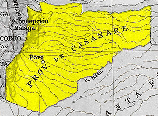
Casanare Province was one of the provinces of Gran Colombia.

Manuel María Paz Delgado was a Colombian cartographer, military officer, artist and watercolorist.


