Planeta Rica

Last updated • a couple of secsFrom Wikipedia, The Free Encyclopedia
Planeta Rica
Municipality and town
TemploNuestraSenoraDeLaCandelaria.png
Flag of Planeta Rica.svg
Escudo de Planeta Rica.svg
Colombia - Cordoba - Planeta Rica.svg
Location of the municipality and town of Planeta Rica in the Córdoba Department of Colombia
Coordinates: 8°24′32″N75°34′55″W / 8.40889°N 75.58194°W / 8.40889; -75.58194
CountryFlag of Colombia.svg  Colombia
Department Córdoba Department
Area
   Municipality and town1,141 km2 (441 sq mi)
  Urban
4.48 km2 (1.73 sq mi)
Population
 (2020 est.) [1] [2]
   Municipality and town64,776
  Density57/km2 (150/sq mi)
   Urban
41,267
  Urban density9,200/km2 (24,000/sq mi)
Time zone UTC-5 (Colombia Standard Time)

Planeta Rica is a town and municipality located in the Córdoba Department, northern Colombia.

According to 2020 estimates, the population of Planeta Rica was 64,776, with a population density of 57 persons per square kilometer.

Climate

Climate data for Planeta Rica, elevation 90 m (300 ft), (1981–2010)
MonthJanFebMarAprMayJunJulAugSepOctNovDecYear
Mean daily maximum °C (°F)33.7
(92.7)
34.7
(94.5)
34.6
(94.3)
33.5
(92.3)
32.3
(90.1)
32.0
(89.6)
32.1
(89.8)
32.0
(89.6)
31.9
(89.4)
31.7
(89.1)
31.8
(89.2)
32.4
(90.3)
32.7
(90.9)
Daily mean °C (°F)27.8
(82.0)
28.0
(82.4)
28.3
(82.9)
28.2
(82.8)
27.7
(81.9)
27.7
(81.9)
27.6
(81.7)
27.5
(81.5)
27.3
(81.1)
27.2
(81.0)
27.2
(81.0)
27.5
(81.5)
27.6
(81.7)
Mean daily minimum °C (°F)22.7
(72.9)
23.0
(73.4)
23.2
(73.8)
23.6
(74.5)
23.6
(74.5)
23.3
(73.9)
23.0
(73.4)
22.9
(73.2)
23.0
(73.4)
23.0
(73.4)
23.0
(73.4)
22.9
(73.2)
23.1
(73.6)
Average precipitation mm (inches)13.3
(0.52)
17.5
(0.69)
49.0
(1.93)
132.5
(5.22)
208.9
(8.22)
213.8
(8.42)
205.2
(8.08)
241.4
(9.50)
192.6
(7.58)
165.4
(6.51)
100.2
(3.94)
45.4
(1.79)
1,531.8
(60.31)
Average precipitation days3351014141517151395118
Average relative humidity (%)78777678828282838383838281
Mean monthly sunshine hours 195.3172.2155.0129.0130.2147.0170.5173.6138.0148.8153.0176.71,889.3
Mean daily sunshine hours 6.36.15.04.34.24.95.55.64.64.85.15.75.2
Source: Instituto de Hidrologia Meteorologia y Estudios Ambientales [3]
Climate data for Planeta Rica (Centro Alegre), elevation 170 m (560 ft), (1981–2010)
MonthJanFebMarAprMayJunJulAugSepOctNovDecYear
Mean daily maximum °C (°F)33.8
(92.8)
34.0
(93.2)
34.2
(93.6)
33.7
(92.7)
32.8
(91.0)
33.0
(91.4)
32.7
(90.9)
32.6
(90.7)
32.7
(90.9)
32.5
(90.5)
32.5
(90.5)
32.7
(90.9)
33.1
(91.6)
Daily mean °C (°F)28.1
(82.6)
28.2
(82.8)
28.3
(82.9)
28.1
(82.6)
27.7
(81.9)
27.8
(82.0)
27.6
(81.7)
27.6
(81.7)
27.5
(81.5)
27.3
(81.1)
27.6
(81.7)
27.8
(82.0)
27.8
(82.0)
Mean daily minimum °C (°F)22.5
(72.5)
22.9
(73.2)
22.7
(72.9)
22.8
(73.0)
22.6
(72.7)
22.6
(72.7)
22.4
(72.3)
22.4
(72.3)
22.3
(72.1)
22.3
(72.1)
22.7
(72.9)
22.6
(72.7)
22.6
(72.7)
Average precipitation mm (inches)58.2
(2.29)
139.0
(5.47)
113.4
(4.46)
104.1
(4.10)
140.9
(5.55)
137.1
(5.40)
131.5
(5.18)
160.9
(6.33)
156.4
(6.16)
141.2
(5.56)
225.8
(8.89)
202.5
(7.97)
1,711
(67.36)
Average precipitation days34510151416161414104124
Average relative humidity (%)80797880838383848484848382
Source: Instituto de Hidrologia Meteorologia y Estudios Ambientales [3]

Related Research Articles

<span class="mw-page-title-main">Demographics of Costa Rica</span> Ethnic group

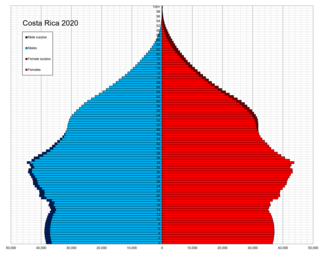
This is a demographic article about Costa Rica's population, including population density, ethnicity, education level, health of the populace, economic status, religious affiliations, and other aspects of the population.

<span class="mw-page-title-main">Córdoba, Spain</span> Municipality in Andalusia, Spain

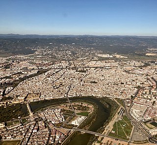
Córdoba, or sometimes Cordova, is a city in Andalusia, Spain, and the capital of the province of Córdoba. It is the third most populated municipality in Andalusia.

<span class="mw-page-title-main">Veracruz</span> State of Mexico

Veracruz, formally Veracruz de Ignacio de la Llave, officially the Estado Libre y Soberano de Veracruz de Ignacio de la Llave, is one of the 31 states which, along with Mexico City, comprise the 32 Federal Entities of Mexico. Located in eastern Mexico, Veracruz is bordered by seven states, which are Tamaulipas, San Luis Potosí, Hidalgo, Puebla, Oaxaca, Chiapas, and Tabasco. Veracruz is divided into 212 municipalities, and its capital city is Xalapa-Enríquez.

<span class="mw-page-title-main">Córdoba, Veracruz</span> City in Veracruz, Mexico

Córdoba, known officially as Heroica Córdoba, is a city and the seat of the municipality of the same name in the Mexican state of Veracruz. It was founded in 1618.

<span class="mw-page-title-main">Córdoba Department</span> Department of Colombia

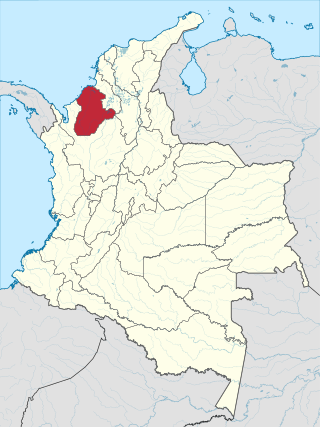
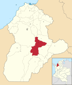
Córdoba Department is a Department of the Republic of Colombia located to the north of this country in the Colombian Caribbean Region. Córdoba faces to the north with the Caribbean Sea, to the northeast with the Sucre Department, east with the Bolívar Department and south with the Antioquia Department. As of 2018, the population of Córdoba was estimated to be 1,784,783. Its capital is the city of Montería.

<span class="mw-page-title-main">Ska-P</span> Spanish ska punk band

Ska-P is a Spanish ska punk band formed in 1994 in Vallecas, a district of Madrid, by a group of friends from Madrid, Navarre and Euskadi.

<span class="mw-page-title-main">Escazú (canton)</span> Canton in San José province, Costa Rica

Escazú is the second canton in the province of San José in Costa Rica.

<span class="mw-page-title-main">Antonio Gala</span> Spanish writer (1930–2023)

Antonio Gala Velasco was a Spanish poet, playwright, novelist, and writer.

<span class="mw-page-title-main">Tolox</span> Place in Andalusia, Spain


Tolox is a town and municipality in the province of Málaga in the autonomous community of Andalusia in southern Spain. The municipality has a population of 2,317 (2006). It is situated in the centre of the Sierra de las Nieves Nature Park at the foot of the Sierra Blanca and the Sierra Parda. In addition to La Torrecilla peak, there are ancient woodlands of Spanish Fir and gall oak. The municipality covers 94 km2, has a mean elevation of 285 m. and mean geographical coordinates of 36° 41' 11" N, 4° 54' 16" E. The channel of the Rio Grande flows through the town from northeast to south.

<span class="mw-page-title-main">Cantons of Costa Rica</span> Political subdivision of Costa Rica

Costa Rica is administratively divided into seven provinces which are subdivided into 84 cantons, and these are further subdivided into districts. Cantons are the only administrative division in Costa Rica that possess local government in the form of municipalities. Each municipality has its own mayor and several representatives, all of them chosen via municipal elections every four years.

<span class="mw-page-title-main">Ayapel</span> Municipality and town in Córdoba Department, Colombia

Ayapel is a town and municipality located in the Córdoba Department, northern Colombia.

<span class="mw-page-title-main">Montelíbano</span> Municipality and town in Córdoba Department, Colombia

Montelíbano is a town and municipality located in the Córdoba Department of Colombia. It is the seat of the Roman Catholic Diocese of Montelíbano.

<span class="mw-page-title-main">Puerto Libertador</span> Municipality and town in Córdoba Department, Colombia

Puerto Libertador is a town and municipality located in the Córdoba Department, northern Colombia.

<span class="mw-page-title-main">Zapote</span> District in San José canton, San José province, Costa Rica

Zapote the fifth district of the San José canton, in the San José province of Costa Rica. It is one of the administrative units surrounding San José downtown. The district is primarily residential, although there are some government buildings, standing out the Presidential House, seat of the government.

<span class="mw-page-title-main">Tilarán</span> Town and district in Tilarán canton, Costa Rica

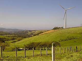
Tilarán is a small town and a district in Guanacaste Province in Costa Rica. It is the seat of the Tilarán Canton located in the hills overlooking the west shore of Lake Arenal. It is connected by road to El Silencio, and by the 142 road down through the Cordillera de Tilarán hills to Tejona. The area between Tilaran and Tejona is one of the most important wind farms in Costa Rica and turbines are prominent on the landscape. Animal husbandry also forms an important part of the local economy.

"Rica y Apretadita" is a song by Panamanian reggae singer El General, featuring Anayka, released in 1995.

Cañas Dulces is a district of the Liberia canton, in the Guanacaste province of Costa Rica.

This is a list of Spanish television related events in 2003.

The Spanish conquest of Nicaragua was the campaign undertaken by the Spanish conquistadores against the natives of the territory now incorporated into the modern Central American republic of Nicaragua during the colonisation of the Americas. Before European contact in the early 16th century, Nicaragua was inhabited by a number of indigenous peoples. In the west, these included Mesoamerican groups such as the Chorotega, the Nicarao, and the Subtiaba. Other groups included the Matagalpa and the Tacacho.

San Lorenzo is a district of the San Ramón canton, in the Alajuela province of Costa Rica.

References

  1. "Resultados y proyecciones (2005-2020) del censo 2005" . Retrieved 12 April 2020.
  2. Citypopulation.de Population of Planeta Rica municipal
  3. 1 2 "Promedios Climatológicos 1981–2010" (in Spanish). Instituto de Hidrologia Meteorologia y Estudios Ambientales. Archived from the original on 15 August 2016. Retrieved 17 June 2024.