
Veracruz, formally Veracruz de Ignacio de la Llave, officially the Estado Libre y Soberano de Veracruz de Ignacio de la Llave, is one of the 31 states which, along with Mexico City, comprise the 32 Federal Entities of Mexico. Located in eastern Mexico, Veracruz is bordered by seven states, which are Tamaulipas, San Luis Potosí, Hidalgo, Puebla, Oaxaca, Chiapas, and Tabasco. Veracruz is divided into 212 municipalities, and its capital city is Xalapa-Enríquez.

Cesar Department or simply Cesar is a department of Colombia located in the north of the country in the Caribbean region, bordering to the north with the Department of La Guajira, to the west with the Department of Magdalena and Department of Bolivar, to the south with Department of Santander, to the east with the Department of North Santander, and further to the east with the country of Venezuela. The department capital city is Valledupar.
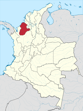
Córdoba Department is a Department of the Republic of Colombia located to the north of this country in the Colombian Caribbean Region. Córdoba faces to the north with the Caribbean Sea, to the northeast with the Sucre Department, east with the Bolívar Department and south with the Antioquia Department. As of 2018, the population of Córdoba was estimated to be 1,784,783. Its capital is the city of Montería.

Sucre is a department in the Caribbean Region of Colombia. The department ranks 27th by area, 10,670 km2 (4,120 sq mi) and it has a population of 904,863, ranking 20th of all the 32 departments of Colombia. Sucre is bordered by the Caribbean on the northwest; by Bolívar Department on the east and by Córdoba Department on the west.

Montería is a municipality and city located in northern Colombia and the capital of the Department of Córdoba. The city is located 50 km (31 mi) away from the Caribbean sea, by the Sinú River. The city and region are known for their distinct cultural heritages, which include a blend of mainly colonial Spanish descendants, indigenous Zenú peoples, Crypto-Jews, and more recently, Middle East immigrants. The city is home to the Sombrero Vueltiao, a national symbol; and is the home of Porro folklore music. The city has an inland seaport connected to the Caribbean Sea by the Sinú River.
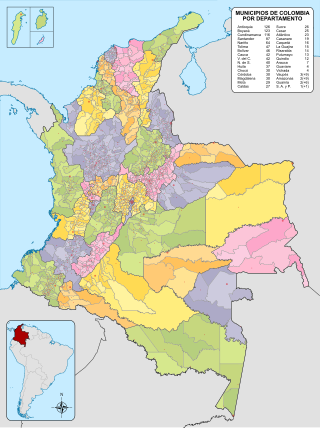
The municipalities of Colombia are decentralized subdivisions of the Republic of Colombia. Municipalities make up most of the departments of Colombia with 1,122 municipalities (municipios). Each one of them is led by a mayor (alcalde) elected by popular vote and represents the maximum executive government official at a municipality level under the mandate of the governor of their department which is a representative of all municipalities in the department; municipalities are grouped to form departments.

San Juan del Cesar is a municipality and town located in the La Guajira Department, Colombia.

The porro is a musical style and dance from the Caribbean region of Colombia. It is a Colombian cumbia rhythm that developed into its own subgenre. It was originally a folkloric expression from the Sinú River area that evolved into a ballroom dance. It is played mostly by brass bands or orchestras, and danced in couples. This genre influenced some of the greatest Latin American bands of the 1960s, with songs such as "Pachito E'ché", "Se va el Caimán", and "Me voy pa'Cataca"

The Caribbean region of Colombia or Caribbean coast region is in the north of Colombia and is mainly composed of 8 departments located contiguous to the Caribbean. It's the second most populated region in the country after Andean Region with approximately 11 million residents according to the Colombian Census 2018. The area covers a total land area of 110,000 km2 (42,000 sq mi), including the Archipelago of San Andrés, Providencia and Santa Catalina in the Caribbean Sea.

San Carlos is a town and municipality located in the Córdoba Department, northern Colombia. According to 2018 estimates, the population of San Carlos was 23,532.
San Pelayo is a town and municipality located in the Córdoba Department, northern Colombia. According to 2020 estimates, the population of San Pelayo was 45,816.

Puente Nacional is an agricultural town and municipality in the Suárez River Valley, part of the Santander Department of northeastern Colombia. Colloquially referred to as "Puente" by its inhabitants.

Altamirano is a municipality in the Mexican state of Chiapas. The municipality covers an area of 1120 km2. As of 2010, the municipality had a total population of 29,865, up from 21,948 as of 2005.

Los Garzones International Airport is an international airport serving the city of Montería in the Córdoba Department of Colombia. It is the only airport in the department that can handle modern jets. On normal days, the airport receives between 20 and 30 takeoffs and landings, and is one of the busiest airports in Colombia's Caribbean region in terms of passenger flow.
The Gulf of Morrosquillo is a gulf of the Caribbean Sea bounded by the Colombian Departments of Sucre and Córdoba. From West to East it runs approximately 80 kilometres (50 mi) from Boca de Tinajones, mouth of Sinú River, in Córdoba, to Punta San Bernardo in Sucre.
Luis Enrique Rueda Otero was a dentist, today regarded as the “Father of Dentistry” in the Colombian department of Córdoba. A renowned Colombian dentist, politician, community organizer, athlete, artist and philanthropist, Dr. Rueda-Otero obtained his DDS degree from the Facultad Dental de Cartagena in 1932.

Estadio Jaraguay is a multi-use stadium in Montería, Colombia. It is currently used mostly for football matches. The stadium was built in 2012 for the National Games of Colombia, with a capacity of 8,000 people, which was raised by 4,000 seats in 2017 with the construction of a new grandstand in the stadium's eastern side. Jaguares de Córdoba play their home matches at this stadium.
The Montería Fault is a thrust fault in the department of Córdoba in northern Colombia. The fault has a total length of 202.2 kilometres (125.6 mi) and runs along an average north-northwest to south-southeast strike of 010 ± 4 in the Sinú-San Jacinto Basin.
Soad Louis Lakah was a Colombian writer and poet, being the first from Córdoba who, during the 60s, dared to build a narrative and investigative work about the cultural ancestors of Sinú and its Syrian origins, in addition to being a cultural reference. manager who preserved those values.
Elías Bechara Zainúm was a Colombian educator, philanthropist and chemist-bacteriologist, founder of the University of Córdoba and the Sinú University, in Colombia.


