Ayapel

Last updated • a couple of secsFrom Wikipedia, The Free Encyclopedia
Ayapel
Municipality and town
Ayapel, Cordoba - Colombia.jpg
Flag of Ayapel (Cordoba).svg
Escudo ayapel.jpg
Colombia - Cordoba - Ayapel.svg
Location of the municipality and town of Ayapel in the Córdoba Department of Colombia.
CountryFlag of Colombia.svg  Colombia
Department Córdoba Department
Area
   Municipality and town1,965 km2 (759 sq mi)
  Urban
14.05 km2 (5.42 sq mi)
Population
 (2020 est.) [1] [2]
   Municipality and town47,247
  Density24/km2 (62/sq mi)
   Urban
27,729
  Urban density2,000/km2 (5,100/sq mi)
Time zone UTC-5 (Colombia Standard Time)

Ayapel is a town and municipality located in the Córdoba Department, northern Colombia.

Ayapel is a Colombian municipality located in the far eastern department of Cordoba and bathed by the waters of San Jorge and Ayapel swamp. Bounded on the north by San Marcos, San Benito Abad, and Majagual, on the east by Guaranda and Achi, on the west by Buenavista and Montelibano, Pueblo Nuevo and south to the department of Antioquia. According to 2020 estimates, the population of Ayapel was 47,247.

Climate

Climate data for Ayapel, elevation 22 m (72 ft), (1981–2010)
MonthJanFebMarAprMayJunJulAugSepOctNovDecYear
Mean daily maximum °C (°F)33.1
(91.6)
33.9
(93.0)
34.3
(93.7)
33.9
(93.0)
32.9
(91.2)
32.6
(90.7)
32.6
(90.7)
32.4
(90.3)
32.0
(89.6)
31.9
(89.4)
32.0
(89.6)
32.4
(90.3)
32.8
(91.0)
Daily mean °C (°F)27.8
(82.0)
28.4
(83.1)
28.6
(83.5)
28.4
(83.1)
27.9
(82.2)
27.9
(82.2)
27.8
(82.0)
27.7
(81.9)
27.5
(81.5)
27.3
(81.1)
27.4
(81.3)
27.7
(81.9)
27.8
(82.0)
Mean daily minimum °C (°F)22.7
(72.9)
22.9
(73.2)
23.2
(73.8)
23.6
(74.5)
23.6
(74.5)
23.3
(73.9)
23.1
(73.6)
23.1
(73.6)
23.0
(73.4)
23.1
(73.6)
23.5
(74.3)
23.3
(73.9)
23.2
(73.8)
Average precipitation mm (inches)18.1
(0.71)
28.8
(1.13)
49.1
(1.93)
162.9
(6.41)
267.2
(10.52)
290.9
(11.45)
380.7
(14.99)
397.2
(15.64)
326.9
(12.87)
266.8
(10.50)
198.7
(7.82)
51.7
(2.04)
2,439.1
(96.03)
Average precipitation days23511161719201817147145
Average relative humidity (%)81797881848584858585858483
Mean monthly sunshine hours 182.9152.4139.5120.0130.2129.0170.5161.2141.0139.5138.0155.01,759.2
Mean daily sunshine hours 5.95.44.54.04.24.35.55.24.74.54.65.04.8
Source: Instituto de Hidrologia Meteorologia y Estudios Ambientales [3]

Related Research Articles

<span class="mw-page-title-main">Córdoba Department</span> Department of Colombia

Córdoba is a Department of the Republic of Colombia located to the north of this country in the Colombian Caribbean Region. Córdoba faces to the north with the Caribbean Sea, to the northeast with the Sucre Department, east with the Bolívar Department and south with the Antioquia Department. As of 2018, the population of Córdoba was estimated to be 1,784,783. Its capital is the city of Montería.

<span class="mw-page-title-main">Rionegro</span> City in Antioquia, Department of Colombia

Rionegro is a city and municipality in Antioquia Department, Colombia, located in the subregion of Eastern Antioquia. The official name of the city is Ciudad Santiago de Arma de Rionegro. Rio Negro means "Black River" in Spanish, as the city received its name after a river that looks black because of the shadows cast by trees. The river traverses the city and it is the most prominent geographical feature of the municipality. Rionegro is also sometimes called the Cuna de la democracia as it was one of the most important cities during the era of the Colombia's struggle for independence and the 1863 constitution was written in the city.

<span class="mw-page-title-main">Buenavista, Córdoba</span> Municipality and town in Córdoba Department, Colombia

Buenavista is a town and municipality located in the Córdoba Department, northern Colombia. According to 2018 estimates, the population of Buenavista was 18,344.

<span class="mw-page-title-main">Cereté</span> Municipality and town in Cordoba, Colombia

Cereté is a town and municipality located in the Córdoba Department, northern Colombia. According to 2020 estimates, the population of Cereté town and municipality was 108,409.

<span class="mw-page-title-main">Chimá</span> Municipality and town in Córdoba Department, Colombia

Chimá is a town and municipality located in the Córdoba Department, northern Colombia. According to 2018 estimates, the population of Chimá was 13,492, with a population density of 40 persons per square kilometer.

<span class="mw-page-title-main">Chinú</span> Municipality and town in Córdoba Department, Colombia

Chinú is a town and municipality located in the Córdoba Department, northern Colombia. According to 2020 estimates, the population of Chinú was 50,743, with a population density of 81 persons per square kilometer.

<span class="mw-page-title-main">Cotorra</span> Municipality and town in Córdoba Department, Colombia

Cotorra is a town and municipality located in the Córdoba Department, northern Colombia. According to 2018 estimates, the population of Cotorra was 16,215, with a population density of 180 persons per square kilometer.

<span class="mw-page-title-main">La Apartada</span> Municipality and town in Córdoba Department, Colombia

La Apartada is a town and municipality located in the Córdoba Department, northern Colombia. According to 2020 estimates, the population of La Apartada was 13,742, with a population density of 57 persons per square kilometer.

<span class="mw-page-title-main">Santa Cruz de Lorica</span> Municipality and town in Córdoba Department, Colombia

Santa Cruz de Lorica is a town and municipality located in the Córdoba Department, northern Colombia.

<span class="mw-page-title-main">Montelíbano</span> Municipality and town in Córdoba Department, Colombia

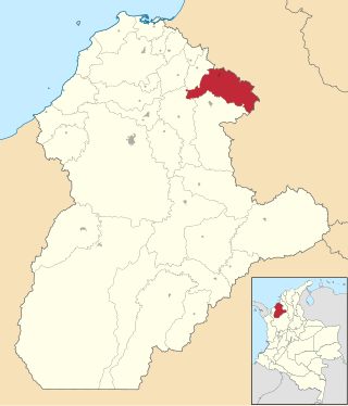
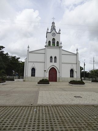
Montelíbano is a town and municipality located in the Córdoba Department of Colombia. It is the seat of the Roman Catholic Diocese of Montelíbano.

<span class="mw-page-title-main">Pueblo Nuevo, Córdoba</span> Municipality and town in Córdoba Department, Colombia

Pueblo Nuevo is a town and municipality located in the Córdoba Department, northern Colombia.

<span class="mw-page-title-main">Puerto Libertador</span> Municipality and town in Córdoba Department, Colombia

Puerto Libertador is a town and municipality located in the Córdoba Department, northern Colombia.

<span class="mw-page-title-main">Purísima</span> Municipality and town in Córdoba Department, Colombia

Purísima is a town and municipality located in the Córdoba Department, northern Colombia.

<span class="mw-page-title-main">Sahagún, Córdoba</span> Municipality and town in Córdoba Department, Colombia

Sahagún is a town and municipality located in the Córdoba Department, northern Colombia. As of 2020, the town population was estimated at 110,233.

<span class="mw-page-title-main">San Andrés de Sotavento</span> Municipality and town in Córdoba Department, Colombia

San Andrés de Sotavento is a town and municipality located in the Córdoba Department, northern Colombia.

<span class="mw-page-title-main">San Bernardo del Viento</span> Municipality and town in Córdoba Department, Colombia

San Bernardo del Viento is a town and municipality located in the Córdoba Department, northern Colombia. It is best known for its elegant spices and unique style of dance.

<span class="mw-page-title-main">San Carlos, Córdoba</span> Municipality and town in Córdoba Department, Colombia

San Carlos is a town and municipality located in the Córdoba Department, northern Colombia. According to 2018 estimates, the population of San Carlos was 23,532.

<span class="mw-page-title-main">San Pelayo, Córdoba</span> Municipality and town in Córdoba, Colombia

San Pelayo is a town and municipality located in the Córdoba Department, northern Colombia. According to 2020 estimates, the population of San Pelayo was 45,816.

<span class="mw-page-title-main">San Marcos, Sucre</span> Municipality and town in Sucre Department, Colombia

San Marcos is a town and municipality located in the Sucre Department, northern Colombia. It is also called "La Perla del San Jorge".

<span class="mw-page-title-main">Hacarí</span> Municipality and town in Norte de Santander Department, Colombia

Hacarí is a Colombian municipality located in the department of North Santander.

References

  1. "Resultados y proyecciones (2005-2020) del censo 2005" . Retrieved 12 April 2020.
  2. Citypopulation.de Population of Ayapel municipality
  3. "Promedios Climatológicos 1981–2010" (in Spanish). Instituto de Hidrologia Meteorologia y Estudios Ambientales. Archived from the original on 15 August 2016. Retrieved 17 June 2024.

8°19′N75°09′W / 8.317°N 75.150°W / 8.317; -75.150