Department of Cundinamarca is one of the departments of Colombia. Its area covers 22,623 square kilometres (8,735 sq mi) and it has a population of 2,919,060 as of 2018. It was created on August 5, 1886 under the constitutional terms presented on the same year. Cundinamarca is located in the center of Colombia.

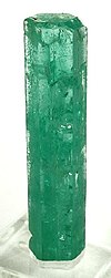
The Gachalá Emerald, one of the most valuable and famous emeralds in the world, was found in the year 1967, in the mine called Vega de San Juan, located in Gachala, a town in Colombia, located 142 km (88 mi) from Bogota. Gachalá Chibcha means "place of Gacha." Presently the emerald is in the United States, where it was donated to the Smithsonian Institution by the New York City jeweler, Harry Winston.

Chivor is a town and municipality in the Eastern Boyacá Province, part of the Colombian department of Boyacá. The mean temperature of the village in the Tenza Valley is 18 °C (64 °F) and Chivor is located at 215 kilometres (134 mi) from the department capital Tunja. Chivor is world-famous for its emeralds.

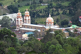
Guateque is a town and municipality in the Colombian Department of Boyacá, part of the subregion of the Eastern Boyacá Province. Guateque's urban center is located at an altitude of 1,815 metres (5,955 ft) on the Altiplano Cundiboyacense at distances of 125 kilometres (78 mi) from the department capital Tunja and 112 kilometres (70 mi) from Bogotá, capital of Colombia. It borders the municipalities of La Capilla, Tenza, Sutatenza, Somondoco of Boyacá and Tibiritá and Manta of Cundinamarca.

Guayatá is a town and municipality in the Eastern Boyacá Province, part of the Colombian department of Boyacá. Guayatá is situated on the Altiplano Cundiboyacense at distances of 129 kilometres (80 mi) from the department capital Tunja and 132 kilometres (82 mi) from the national capital Bogotá. The urban centre is located at an altitude of 1,767 metres (5,797 ft) and the altitude ranges from 1,270 metres (4,170 ft) to 3,080 metres (10,100 ft).

Somondoco is a town and municipality in the Colombian Department of Boyacá. This town and larger municipal area are located in the Valle de Tenza. The Valle de Tenza is the ancient route connecting the Altiplano Cundiboyacense and the Llanos. The area is dotted with many such little towns all located at approximately the same altitude. Somondoco borders Almeida in the east, Guayatá in the west, Guateque and Sutatenza in the north and in the south the Cundinamarca municipality of Ubalá.

Choachí is a municipality and town of Colombia in the Eastern Province of the department of Cundinamarca. The municipality borders La Calera in the north, Ubaque in the south, in the east Fómeque and westward of Choachí is the Colombian capital Bogotá. The town centre is located at 38 kilometres (24 mi) from the centre of the capital. Within the boundaries of Choachí the Páramo de Cruz Verde is situated.

Gachetá is a municipality and town of Colombia, capital of the Guavio Province, part of the department of Cundinamarca. The urban centre of Gachetá is situated at an altitude of 1,745 metres (5,725 ft) in the Eastern Ranges of the Colombian Andes. The municipality borders Machetá and Manta in the north, the department of Boyacá and Ubalá in the east, Gama and Junín in the south and Guatavita in the west.

Gama is a municipality and town of Colombia in the Guavio Province, part of the department of Cundinamarca. The urban centre of Gama is situated at an altitude of 2,180 metres (7,150 ft) in the Eastern Ranges of the Colombian Andes. Gama, at 118 kilometres (73 mi) from the capital Bogotá, borders Gachetá in the north, Junín and Gachalá in the south, Ubalá in the east and Junín in the west.

Junín is a municipality and town of Colombia in the Guavio Province, part of the department of Cundinamarca. The urban centre is situated at an altitude of 2,300 metres (7,500 ft) in the east of the Altiplano Cundiboyacense. Junín borders Gachetá and Guatavita in the north, Gama and Gachalá in the east, Fómeque in the south, and La Calera and Guasca in the west.

La Calera is a municipality and town of Colombia in the Guavio Province, part of the department of Cundinamarca. La Calera is a common weekend destination, mainly for the many restaurants, as it is approximately 18 kilometres (11 mi) over land from Bogotá, the capital city of Colombia. La Calera is located in the Eastern Ranges of the Colombian Andes, east of the capital and overlooking part of it. La Calera borders Guasca, Sopó and Chía in the north, Guasca and Junín in the east, Bogotá in the west and Choachí and Fómeque in the south.

Quetame is a municipality and town of Colombia in the Eastern Province, part of the department of Cundinamarca. The urban centre of Quetame is located at 62 kilometres (39 mi) from the capital Bogotá at an altitude of 1,496 metres (4,908 ft). The municipality borders Fómeque in the north, Fosca and Cáqueza in the west, the department of Meta in the east and in the south with Guayabetal.

Ubalá is a municipality and town of Colombia in the department of Cundinamarca. It is located in the Eastern Ranges of the Colombian Andes. It is the only municipality of Cundinamarca that is split in two parts.
Ubaque is a municipality and town of Colombia in the Eastern Province of the department of Cundinamarca. Ubaque borders the municipalities Choachí in the north, Fómeque in the east, Cáqueza and Chipaque in the south and in the west is the Colombian capital Bogotá at 56 km away.
The Guavio Province is one of the 15 provinces in the Cundinamarca department, Colombia. Guavio borders the Capital District of Bogotá and the Central Savanna Province to the west, to the north the Almeidas Province, to the east the Boyacá Department and Medina Province and to the south the Meta Department and the Eastern Province. The Alberto Lleras Dam is also located in this area. The eastern municipalities Gachalá and Ubalá are rich in emeralds.

Chingaza National Natural Park is located in the Eastern Ranges of the Colombian Andes, northeast of Bogotá, Colombia in the departments of Cundinamarca and Meta. The elevation in the park, to the east of the Altiplano Cundiboyacense, ranges from 800 metres (2,600 ft) to 4,020 metres (13,190 ft), and the temperature ranges from 4 to 21.5 °C. The park extends over the Cundinamarca municipalities La Calera, Fómeque, Guasca and San Juanito (Meta).

Emeralds are green precious gemstones that are mined in various geological settings. They are minerals in the beryl group of silicates. For more than 4,000 years, emeralds have been among the most valuable of all jewels. Colombia, located in northern South America, is the country that mines and produces the most emeralds for the global market. It is estimated that Colombia accounts for 70–90% of the world's emerald market. While commercial grade emeralds are quite plentiful, fine and extra fine quality emeralds are extremely rare. Colombian emeralds over 50 carat can cost much more than diamonds of the same size.
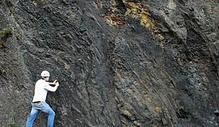
The Macanal Formation or Macanal Shale is a fossiliferous geological formation of the Altiplano Cundiboyacense and Tenza Valley in the Eastern Ranges of the Colombian Andes. The predominantly organic shale formation dates to the Early Cretaceous period; Berriasian to Valanginian epochs and has a maximum thickness of 2,935 metres (9,629 ft). The Macanal Formation contains numerous levels of fossiliferous abundances. Bivalves, ammonites and fossil flora have been found in the formation.
The Guavio Formation is a geological formation of the Altiplano Cundiboyacense, Eastern Ranges of the Colombian Andes. The formation consists of conglomerates, shales and limestones, dates to the Late Jurassic and Early Cretaceous periods; Tithonian to Berriasian epochs and has a maximum thickness of 1,000 metres (3,300 ft).