Tequendama Province

Last updated
Tequendama Province

Provincia de Tequendama
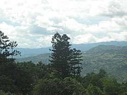
Panorama del Mesitas.JPG
View of La Mesa
Etymology: Tequendama
Colombia - Cundinamarca - Tequendama.svg
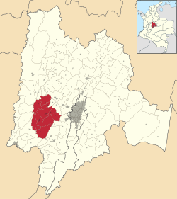
Location of Tequendama Province in Colombia
Coordinates: 4°37′58″N74°21′08″W / 4.63278°N 74.35222°W / 4.63278; -74.35222 Coordinates: 4°37′58″N74°21′08″W / 4.63278°N 74.35222°W / 4.63278; -74.35222
Country Colombia
Department Cundinamarca
Capital San Antonio del Tequendama
Municipalities 10
Time zone UTC−05:00 (COT)
Indigenous groups Panche
Muisca

Tequendama Province is one of the 15 provinces in the Cundinamarca Department, Colombia.

Contents

Etymology

The name Tequendama means in the Chibcha language of the Muisca; "he who precipitates downward". [1]

Subdivision

Tequendama Province comprises ten municipalities:

Related Research Articles

Cundinamarca Department Department of Colombia

Department of Cundinamarca is one of the departments of Colombia. Its area covers 22,623 square kilometres (8,735 sq mi) and it has a population of 2,598,245 as of 2013. It was created on August 5, 1886 under the constitutional terms presented on the same year. Cundinamarca is located in the center of Colombia.

Bogotá River River in Colombia

The Bogotá River is a major river of the Cundinamarca department of Colombia, crossing the region from the northeast to the southwest and passing along the western limits of Bogotá. The large population and major industrial base in its watershed have resulted in extremely severe pollution problems for the river.

Tequendama Falls waterfall

The Tequendama Falls is a 132 metres (433 ft) high waterfall of the Bogotá River, located 32 kilometres (20 mi) southwest of Bogotá in the municipality of Soacha. Established in approximately 10,000 BCE, El Abra and Tequendama were the first permanent settlements in Colombia. One of the country’s tourist attractions, the falls are located in a forested area 32 kilometres (20 mi) west of Bogotá. The river surges through a rocky gorge that narrows to about 18 metres (59 ft) at the brink of the 132 metres (433 ft) high falls. During the month of December the falls become completely dry. The falls, once a common site for suicides, may be reached by road from Bogotá.

Anapoima Place in Cundinamarca, Colombia

Anapoima is a Colombian municipality in the department of Cundinamarca located 87 km (54 mi) from Bogotá.

Bojacá Municipality and town in Cundinamarca, Colombia

Bojacá is a municipality and town of the Western Savanna Province, Colombia in the department of Cundinamarca. The urban centre is situated at an altitude of 2,598 metres (8,524 ft) on the Bogotá savanna at 40 kilometres (25 mi) from the capital Bogotá. The municipality borders Zipacón, Madrid and Facatativá in the north, Madrid and Mosquera in the east, Soacha and San Antonio del Tequendama in the south and Tena, La Mesa and Zipacón in the west.

Cachipay, Cundinamarca Municipality and town in Cundinamarca, Colombia

Cachipay is a municipality and town of Colombia in the Tequendama Province, part of the department of Cundinamarca. Cachipay borders Quipile in the west, Zipacón in the east, Anolaima in the north and La Mesa in the south. The urban centre is located 53 kilometres (33 mi) east of Bogotá.

Quipile Municipality and town in Cundinamarca, Colombia

Quipile is a municipality and town of Colombia in the Tequendama Province of the department of Cundinamarca. The municipality borders Bituima and Vianí in the north, Jerusalén and Anapoima in the south, Anolaima, Cachipay and La Mesa in the east and San Juan de Rioseco and Pulí in the west. The urban centre is located at an altitude of 2,012 metres (6,601 ft) at a distance of 83 kilometres (52 mi) from the capital Bogotá.

San Antonio del Tequendama Municipality and town in Cundinamarca, Colombia

San Antonio del Tequendama is a municipality and town of Colombia in the Tequendama Province part of the department of Cundinamarca. The municipality is located along the Serranía de Subía in the Tena Valley and borders Tena and Bojacá in the north, Bojacá and Soacha in the east, La Mesa and El Colegio in the west and in the south Soacha and Granada.

Tena, Cundinamarca Municipality and town in Cundinamarca, Colombia

Tena is a municipality and town of Colombia in the Tequendama Province, part of the department of Cundinamarca. The urban centre is located at an altitude of 1,384 metres (4,541 ft) at a distance of 42 kilometres (26 mi) from the capital Bogotá. The municipality borders Bojaca in the north, La Mesa in the west, San Antonio del Tequendama in the east and El Colegio in the south. The southern border of Tena is formed by the Bogotá River.

Upper Magdalena Province Province in Cundinamarca, Colombia

Upper Magdalena Province is one of the 15 provinces in the Cundinamarca Department, Colombia. Upper Magdalena borders to the west with the Magdalena River and the Tolima Department, to the north with the Central Magdalena Province, to the east with the Tequendama Province and to the southeast with the Sumapaz Province.

Gualivá Province Province in Cundinamarca, Colombia

Gualivá Province is one of the 15 provinces in the Cundinamarca Department, Colombia. Gualivá borders the Lower Magdalena Province to the west, to the north the Rionegro Province, to the east and southeast the Western Savanna Province, to the south slightly the Tequendama Province and to the southwest the Central Magdalena Province.

Central Magdalena Province Province in Cundinamarca, Colombia

Central Magdalena Province is one of the 15 provinces in the Cundinamarca Department, Colombia. Central Magdalena borders to the west the Tolima Department and the Magdalena River, to the north the Lower Magdalena Province, to the east the Gualivá and Tequendama Provinces and to the south the Upper Magdalena Province.

El Abra

El Abra is the name given to an extensive archeological site, located in the valley of the same name. El Abra is situated in the east of the municipality Zipaquirá extending to the westernmost part of Tocancipá in the department of Cundinamarca, Colombia. The several hundred metres long series of rock shelters is in the north of the Bogotá savanna on the Altiplano Cundiboyacense, Eastern Ranges of the Colombian Andes at an altitude of 2,570 metres (8,430 ft). The rock shelter and cave system is one of the first evidences of human settlement in the Americas, dated at 12,400 ± 160 years BP. The site was used by the hunter-gatherers of the Late Pleistocene epoch.

Piedras del Tunjo Archaeological Park Archaeological park

Piedras del Tunjo is an important archaeological park established on a natural rock shelter 40 kilometres (25 mi) west of Bogotá in the city of Facatativá.

Tequendama Falls Museum

The Tequendama Falls Museum of Biodiversity and Culture is a museum and mansion in San Antonio del Tequendama, Colombia. The museum overlooks Tequendama Falls on the Bogotá River. Before renovation, the building was an abandoned hotel, known as the Tequendama Falls Hotel.

Hunzahúa Well

The Hunzahúa Well is an archeological site of the Muisca located in the city of Tunja, Boyacá, which in the time of the Muisca Confederation was called Hunza. The well is named after the first zaque of Hunza; Hunzahúa. The Well was called Pozo de Donato for a while, after 17th century Jerónimo Donato de Rojas. The well is located on the terrain of the Pedagogical and Technological University of Colombia in Tunja. Scholar Javier Ocampo López has written about the Well and its mythology. Knowledge about the well has been provided by scholar Pedro Simón.

Tequendama may refer to:

Tequendama

Tequendama is a preceramic and ceramic archaeological site located southeast of Soacha, Cundinamarca, Colombia, a couple of kilometers east of Tequendama Falls. It consists of multiple evidences of late Pleistocene to middle Holocene population of the Bogotá savanna, the high plateau in the Colombian Andes. Tequendama was inhabited from around 11,000 years BP, and continuing into the prehistorical, Herrera and Muisca periods, making it the oldest site of Colombia, together with El Abra, located north of Zipaquirá. Younger evidences also from the Herrera Period have been found close to the site of Tequendama in Soacha, at the construction site of a new electrical plant. They are dated at around 900 BCE to 900 AD.

Hotel Tequendama national monument of Colombia

The Hotel Tequendama is a historic hotel located in central Bogotá, Colombia.

Aguazuque

Aguazuque is a pre-Columbian archaeological site located in the western part of the municipality Soacha, close to the municipalities Mosquera and San Antonio del Tequendama in Cundinamarca, Colombia. It exists of evidences of human settlement of hunter-gatherers and in the ultimate phase primitive farmers. The site is situated on the Bogotá savanna, the relatively flat highland of the Altiplano Cundiboyacense close to the present-day course of the Bogotá River at an altitude of 2,600 metres (8,500 ft) above sea level. Aguazuque is just north of another Andean preceramic archaeological site; the rock shelter Tequendama and a few kilometres south of Lake Herrera. The artefacts found mostly belong to the preceramic period, and have been dated to 5025 to 2725 BP. Thus, the younger finds also pertain to the later ceramic Herrera Period. There were some difficulties in dating of the uppermost layer due to modern agricultural activity in the area; the sediments of the shallower parts were disturbed.

References

Panorama

Panorama Tequendama 03.jpg
Panorama of the Tena Valley, Tequendama Province