
The Arctic Archipelago, also known as the Canadian Arctic Archipelago, is an archipelago lying to the north of the Canadian continental mainland, excluding Greenland and Iceland.

Acajete Municipality is a municipality located in the central zone in the Mexican state of Veracruz, about 20 km from state capital Xalapa. It has a surface of 90.48 km2. It is located at 19°58′N97°00′W. In the middle of 1586 this village was formed, on one of the adjoining old men of Tlacolulan's dominion. The decree N ° 64 of November 3, 1893, extinguished the municipality of La Hoya, annexing its territory to San Salvador Acajete. On November 5, 1932, the municipal head-board San Salvador Acajete changes the name to Acajete.
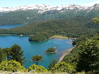
The Araucanía, La Araucanía Region is one of Chile's 16 first-order administrative divisions, and comprises two provinces: Malleco in the north and Cautín in the south. Its capital and largest city is Temuco; other important cities include Angol and Villarrica.

Puerto Boyacá is a Colombian river-port town and municipality by the Magdalena River in the Boyacá Department, where is also considered a Special Trade Zone due to its port status. Its main industries are oil exploration and processing. In the 1980s and early 1990s, Puerto Boyacá was affected intensively by the Colombian Armed Conflict.

La Paz is a municipality in the Mexican state of Baja California Sur. Its area of 20,275 km2 (7,828 sq mi) makes it the municipality in Mexico with the fourth-largest area. It had a population of 290,286 inhabitants in the 2015 census. Its municipal seat, also named La Paz, is the state capital.
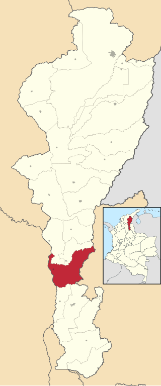
La Gloria is a municipality and town in the Department of Cesar, northern Colombia by the Magdalena River.
Remolino is a town and municipality of the Colombian Department of Magdalena. Founded between 1752 and 1776 by Fernando de Mier y Guerra. Erected municipality in 1814.

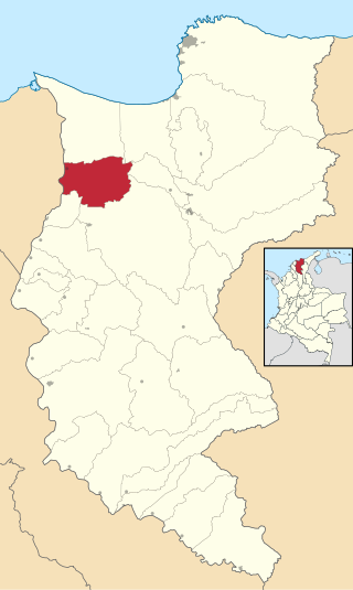
Tenerife is a town and municipality of the Magdalena Department in northern Colombia.

Algadefe is a municipality located in the province of León, Castile and León, Spain. According to the 2010 census (INE), the municipality has a population of 315 inhabitants.

Villaeles de Valdavia is a municipality located in the province of Palencia, Castile and León, Spain. According to the 2004 census (INE), the municipality has a population of 74 inhabitants.

Sotresgudo is a municipality and town located in the province of Burgos, Castile and León, Spain. According to the 2004 census (INE), the municipality has a population of 645 inhabitants.

Tubilla del Lago is a municipality located in the province of Burgos, Castile and León, Spain. According to the 2004 census (INE), the municipality had a population of 170 inhabitants.

Traspinedo is a municipality located in the province of Valladolid, Castile and León, Spain. According to the 2004 census (INE), the municipality has a population of 905 inhabitants.

Velliza is a municipality located in the province of Valladolid, Castile and León, Spain. According to the 2004 census (INE), the municipality has a population of 149 inhabitants.
Coxquihui is a municipality in the Mexican state of Veracruz. It is located in montane central zone of the state, about 95 km from Xalapa, the state capital. It has a surface of 86.37 km2. It is located at 20°11′N97°35′W.

Rafael Lucio is a municipality located in the montane central zone of the Mexican state of Veracruz, about 9 km from the state capital Xalapa. It has a surface of 24.68 km2. It is located at 19°35′N96°59′W.
Texcatepec is a municipality in the Mexican state of Veracruz, about 190 km from the state capital Xalapa. It has a surface of 153.61 km2. It is located at 20°35′N98°22′W. In 1930 the municipal head-board was established in the village of Amexac; but for the decree number 4 in 1931 returned the character of municipal head-board, to the village of Texcatepec.

Banderilla is a municipality in the Mexican state of Veracruz. It is located about 9 km from the state capital, Xalapa. It has a surface area of 22.21 km2. It is located at 19°35′N96°56′W.

Hinojales is a town and municipality located in the province of Huelva, Spain. According to the 2008 census, the municipality had a population of 338 inhabitants.


