The Arctic Archipelago, also known as the Canadian Arctic Archipelago, is an archipelago lying to the north of the Canadian continental mainland, excluding Greenland and Iceland.

Lääne-Viru County is one of 15 counties of Estonia. It is in northern Estonia, on the south coast of the Gulf of Finland. In Estonian, lääne means western and ida means east or eastern. Lääne-Viru borders Ida-Viru County to the east, Jõgeva County to the south, and Järva and Harju counties to the west. In January 2013, Lääne-Viru County had a population of 58,806: 4.5% of the population in Estonia.

Angostura is a town and municipality in Antioquia Department, Colombia. It is part of the subregion of Northern Antioquia. The population was 10,500 at the 2018 census.

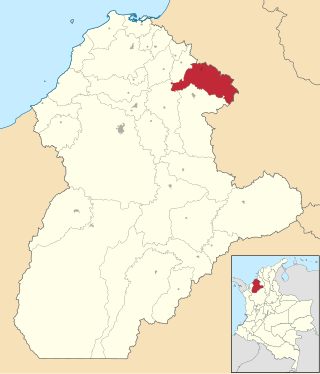
Barbosa is a town and municipality in Antioquia Department, Colombia. Situated 39 km from Medellín's downtown, it is one of the municipalities of the Metropolitan Area of the Aburrá Valley. The population was estimated to be 54,347 in 2020. It is known as the Gateway to the Northeast, famous for its lakes and streams. A traditional Pineapple Festival is held here in December and a Train Festival in the district of El Hatillo in August.

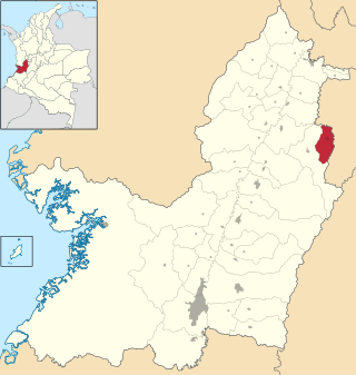
Ebéjico is a town and municipality in the West of Antioquia Department, Colombia. The population was 10,338 at the 2018 census.
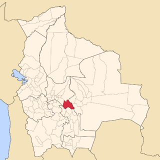
Narciso Campero is a province in the Cochabamba Department, Bolivia. Its capital is Aiquile. Aiquile lies on one transportation route between the cities of Cochabamba, Sucre and Santa Cruz.

Houet is one of the 45 provinces of Burkina Faso, located in its Hauts-Bassins Region. The capital of Houet is Bobo-Dioulasso. In 2019, the province had a population of 1,509,377.

Pijao is a municipality in the south-eastern part of the department of Quindío, Colombia. The town is located 31 km south of the departmental capital Armenia in the Colombian coffee growing axis, it's part of the "Coffee Cultural Landscape" UNESCO World Heritage Site in 2011.

Génova is a municipality in the southern part of the department of Quindío, Colombia. It's located 52 km south of the departmental capital Armenia.

Casas de Ves is a municipality in Albacete, Castile-La Mancha, Spain. It has a population of 870.

Turbaco is a municipality in the Bolívar Department of Colombia. It is located about 20 km southeast of Cartagena de Indias and is one of Bolívar's most organized municipalities. Turbaco is known for its famous "Fiesta de Toros" in December to celebrate the new year. Currently, the municipality is undergoing major expansion plans and remodeling.
Chinú is a town and municipality located in the Córdoba Department, northern Colombia. According to 2020 estimates, the population of Chinú was 50,743, with a population density of 81 persons per square kilometer.

Corozal is a town and municipality in the Sucre Department, northern Colombia.
Caicedonia is a town and municipality located in the Department of Valle del Cauca, Colombia, situated about 172 km from the capital Cali. Founded in 1910 by Daniel Gutierrez, Juan Bautista Angely and a group of settlers from Antioquia, Caldas, and Tolima, it was named after Lisandro Caicedo and became a municipality in 1923. Mostly mountainous, its economy is based on agriculture and commerce, its main exports are corn, coffee, sugarcane and bananas. Given its location on the border with the Quindío Department, only 35 km from that department's capital, Armenia, Caicedonia belongs ethnographically and culturally to the Paisa region.

Trujillo is a town and municipality located in the Department of Valle del Cauca, Colombia.
San Jose de Ocune is a town and municipality located in the Department of Vichada, Colombia.

The Metropolitan Area of the Aburrá Valley is the second most important and populated metropolitan area in Colombia. The region is made up of ten municipalities, Medellín being the most important, largest and the capital city of the Antioquia Department.

Aguilar de Bureba is a municipality and town located in the province of Burgos, Castile and León, Spain. According to the 2004 census (INE), the municipality has a population of 75 inhabitants.

Pozuelo de la Orden is a municipality located in the province of Valladolid, Castile and León, Spain. According to the 2004 census (INE), the municipality has a population of 75 inhabitants.

Nedzingė is a village in Varėna district municipality, in Alytus County, in southeastern Lithuania. According to the 2001 census, the village has a population of 288 people.