Department of Cundinamarca is one of the departments of Colombia. Its area covers 22,623 square kilometres (8,735 sq mi) and it has a population of 2,919,060 as of 2018. It was created on August 5, 1886, under the constitutional terms presented on the same year. Cundinamarca is located in the center of Colombia.

Cesar Department or simply Cesar is a department of Colombia located in the north of the country in the Caribbean region, bordering to the north with the Department of La Guajira, to the west with the Department of Magdalena and Department of Bolivar, to the south with Department of Santander, to the east with the Department of North Santander, and further to the east with the country of Venezuela. The department capital city is Valledupar.

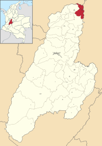
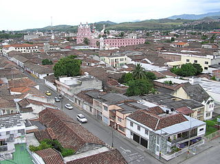
Ibagué is the capital of Tolima, one of the 32 departments that make up the Republic of Colombia. The city is located in the center of the country, on the central mountain range of the Colombian Andes, near Nevado del Tolima. It is one of the most populous cities in the country, with a population of 492,554, making it the eleventh most populous in Colombia, and with a population of 529,625 in the municipality. It was founded on 14 October 1550, by the Spanish captain Andrés López de Galarza. The city of Ibagué is divided into 13 communes and the rural area has 17 corregimientos. As the capital of the department of Tolima the city hosts the Government of Tolima, the Departmental Assembly, and the Attorney General's Office. It is the main epicenter of political, economic, administrative, business, art, culture, and tourism activities in the area.

Puerto Boyacá is a Colombian river-port town and municipality by the Magdalena River in the Boyacá Department, where is also considered a Special Trade Zone due to its port status. Its main industries are oil exploration and processing. In the 1980s and early 1990s, Puerto Boyacá was affected intensively by the Colombian Armed Conflict.

Guaduas is a municipality and town in Colombia, in the Lower Magdalena Province department of Cundinamarca, about 117 km from Bogotá. It is an agricultural and tourist center of some importance with a population of about 33,000 in the municipality. Its name refers to a type of bamboo cane. It is one of the cities on the Bogotá-Medellín highway. Its main plaza is featured on the Colombian ten-thousand pesos bill, and is one of the seats of the Roman Catholic Diocese of La Dorada–Guaduas

Santa Fe de Antioquia is a municipality in the Antioquia Department, Colombia. The city is located approximately 58 kilometres (36 mi) north of Medellín, the department capital. The population was 23,216 at the 2018 census.

Puerto Berrío is a municipality and town in the Colombian department of Antioquia. It is part of the Magdalena Medio Antioquia sub-region.
Buga, formally Guadalajara de Buga, is a city and municipality in the Valle del Cauca Department of Colombia. It is famous for its Basilica del Señor de los Milagros, which houses an image of Christ called el Señor de los Milagros.

The Bogotá River is a major river of the Cundinamarca department of Colombia. A right tributary of the Magdalena River, the Bogotá River crosses the region from the northeast to the southwest and passing along the western limits of Bogotá. The large population and major industrial base in its watershed have resulted in extremely severe pollution problems for the river.

Mompox or Mompós, officially Santa Cruz de Mompox, is a town and municipality in northern Colombia, in the Bolívar Department. The town initially grew from its proximity to the Magdalena river and has preserved much of its colonial character. It also played an important role in the independence of America from Spain. Today, Mompox depends upon tourism, fishing, and some commerce generated by the local cattle raising. The municipality has a population of 46,408 and is adjacent to the municipalities of Pinillos and San Fernando. The historic center of Mompox was made a UNESCO World Heritage Site in 1995, owing to its preserved colonial architecture and mixture of architectural styles.

Teusaquillo is the 13th locality of Bogotá, capital of Colombia. It is located in the geographic center of the city, to the northwest of downtown Bogotá. This district is inhabited by middle and upper class residents. It is an urbanized locality with several green zones as parks, avenues, and the campus of the National University of Colombia. Most of the heritage buildings and houses of Bogotá are in this locality. It is located on the former site of an indigenous resguardo known as Pueblo Viejo, which existed until the main urbanization phase of the 20th century.

Pueblo Bello, is a village and municipality in the northern region of the Department of Cesar, Colombia. It is located in the mountains of the Sierra Nevada de Santa Marta and is home to Amerindians pertaining to the Arhuaco ethnicity, whom consider Pueblo Bello a sanctuary but by the name of Arumake in their language. Pueblo Bello is the main producer of coffee in the Caribbean Region of Colombia.

Ciénaga is a municipality and city in the Magdalena Department, Colombia, the second largest population center in this department, after the city of Santa Marta. It is situated at 11° 00' North, 74° 15' West, between the Sierra Nevada de Santa Marta, the Caribbean Sea and the Ciénaga Grande de Santa Marta marsh in northern Colombia. The city is situated in the northern part of Magdalena, 35 km from Santa Marta. According to estimations in 2020, the city had a population of 110,303. The mean annual temperature is 34 °C.

Aguadas is a town and municipality in the Colombian department of Caldas. It is bordered to the north by Abejorral, to the east by Sonsón, to the southeast by Salamina, to the south by Pacora, to the west by Caramanta and Valparaiso, and to the northwest by La Pintada. The municipality of Aguadas, located in the northern part of the department, was founded in 1808 by José Narciso Estrada. In addition to the fame of Aguadeño hats, which are very similar to palm-straw Panama hats. Aguadas offers visitors its historic center, which was declared a national monument in 1982. It has a temperate climate thanks to the variety of climates ranging from warm to moor.

Líbano is a town and municipality in the Tolima department of Colombia. The population of the municipality was estimated at 36,231 as of 2020. Along with Honda, Líbano is the seat of the Roman Catholic Diocese of Líbano–Honda.
Girardot is a municipality and town of Colombia in the department of Cundinamarca. It is the second most important city of Cundinamarca according to its production. It is home to a number of recreational and vacational spots, mainly visited by people from Bogotá, as it is located at two hours drive from the city but enjoys a tropical climate. The municipality had a population of 109,792, and form a small metropolitan area together with the neighbouring municipalities of Flandes and Ricaurte.

Puente Aranda is the 16th location of the Capital District of the Colombian capital city, Bogotá. It is located in the center part of Bogotá. This district is mostly inhabited by lower middle and working class residents. The district was named after an old bridge in the hacienda of Juan Aranda over the "Chinúa River", now called the San Francisco River, that dates to the 16th century. Puente Aranda has 1,724 hectares of area which are almost entirely urban. This locality has more than 300,000 inhabitants, 5% of the total urban area inhabitants of Bogota.

The contribution of travel and tourism to GDP was US$5,880.3bn in 2016. Tourism generated 556,135 jobs in 2016. Foreign tourist visits were predicted to have risen from 0.6 million in 2007 to 4 million in 2017. Responsible tourism became a peremptory need for Colombia because it minimizes negative social, economic and environmental impacts and makes positive contributions to the conservation of natural and cultural heritage.

The province of Santafé de Bogotá, also known as the government of Santafé during the Spanish imperial era, was originally an administrative and territorial entity of the New Kingdom of Granada. It was created on July 17th, 1550, at which point New Granada was a province within the Viceroyalty of Peru. In 1717, province became part of Viceroyalty of New Granada after King Philip V of Spain issued a real cédula creating the new viceroyalty.

The province of Mariquita, also called the government of Mariquita during the Spanish imperial era, was an administrative and territorial entity of New Granada, created in 1550 as a corregimiento of the Viceroyalty of Peru. In 1717, province became part of Viceroyalty of New Granada after King Philip V of Spain issued a real cédula creating the new viceroyalty.