
The Nevado del Ruiz, also known as La Mesa de Herveo is a volcano on the border of the departments of Caldas and Tolima in Colombia, about 129 kilometers (80 mi) west of the capital city Bogotá. It is a stratovolcano composed of many layers of lava alternating with hardened volcanic ash and other pyroclastic rocks. Volcanic activity at Nevado del Ruiz began about two million years ago, since the Early Pleistocene or Late Pliocene, with three major eruptive periods. The current volcanic cone formed during the present eruptive period, which began 150,000 years ago.

Huila is one of the departments of Colombia. It is located in the southwest of the country, and its capital is Neiva.

Risaralda is a landlocked department of Colombia. It is located in the western central region of the country and part of the Paisa Region. Its capital is Pereira.

Vichada Department is a department of the Republic of Colombia in South America. Vichada is located in the eastern plains of Colombia, in the Orinoquía Region within the Orinoco river basin bordering the Bolivarian Republic of Venezuela to the north and east. To the north the department also borders with Arauca Department, to the northwest with Casanare Department, to the west with Meta Department, to the southwest narrowly bordering with Guaviare Department and to the south with Guainía Department. The department is the second largest in Colombia and scarcely populated in comparison to other departments.

Ibagué is the capital of Tolima, one of the 32 departments that make up the Republic of Colombia. The city is located in the center of the country, on the central mountain range of the Colombian Andes, near Nevado del Tolima. It is one of the most populous cities in the country, with about 529,635 inhabitants, making it the seventh (7th) most populous in Colombia. It was founded on October 14, 1550, by the Spanish captain Andrés López de Galarza. The city of Ibagué is divided into 13 communes and the rural area has 17 corregimientos. As the capital of the department of Tolima the city hosts the Government of Tolima, the Departmental Assembly, and the Attorney General's Office. It is the main epicenter of political, economic, administrative, business, art, culture, and tourism activities in the area.

Cajamarca is a town and municipality in the Tolima Department of Colombia. The population of the municipality was 17,309 as of the 2018 census. The municipality has two populated centres, the town centre of Cajamarca and the locality of Anaime. It is located along the Pan-American Highway.

Esquipulas Palo Gordo is a town and municipality in the San Marcos department of Guatemala. The town was founded on 24 December 1826 year. In the 1920s it was merged with San Marcos, but in 1948 it recovered its autonomy again.

San Cristóbal Cucho is a town and municipality in the San Marcos department of Guatemala.It was found on 11 October 1825. It was annexed to San Pedro Sacatepéquez, in 1935, but it was named a municipality again on 12 July 1945.
Sibinal is a municipality in the San Marcos department of Guatemala. Its name comes from mam tziben (English: "Writing" and nal, meaning "Bernard writings" It was founded in February 1799. It is a mountainous municipality at an altitude about 2500 m near the Mexican-Guatemalan border. The village of Sibinal is one of the points for climbing towards the Volcano Tacaná.

Abejorral is a town and municipality in Antioquia Department, Colombia. Part of the subregion of Eastern Antioquia. It borders to the north with the municipalities of Montebello, La Ceja and La Unión, to the east with municipality of Sonsón, to the south with the department of Caldas and to the west with the municipalities of Santa Bárbara y Montebello.

Salento is a town and municipality in the north-east of the department of Quindío, Colombia. The municipality covers an area of 377.67 km2. It was the first settlement in Quindío of the modern era, and the first municipality founded in the department. The town of Salento itself is located 24 km northeast of the departmental capital Armenia. In 2005 the municipality of Salento had an estimated population of 7247, of which 3597 lived in the main urban zone.

El Hatillo Municipality is an administrative division of the State of Miranda, Venezuela; along with Baruta, Chacao, Libertador and Sucre, it is one of the five municipalities of Caracas, the capital of Venezuela. It is located in the southeastern area of Caracas, and in the northwestern part of the State of Miranda.

The Cordillera Central is the highest of the three branches of the Colombian Andes. The range extends from south to north dividing from the Colombian Massif in Cauca Department to the Serranía de San Lucas in Bolivar Departments. The highest peak is Nevado del Huila at 5,364 m (17,598 ft).
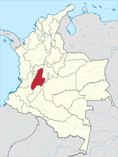
Tolima is one of the 32 departments of Colombia, located in the Andean region, in the center-west of the country. It is bordered on the north and the west by the department of Caldas; on the east by the department of Cundinamarca; on the south by the department of Huila, and on the west by the departments of Cauca, Valle del Cauca, Quindío and Risaralda. Tolima has a surface area of 23,562 km2, and its capital is Ibagué. The department of Tolima was created in 1861 from a part of what was previously Cundinamarca.

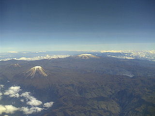
The Nevado del Tolima is a Late Pleistocene to recently active andesitic stratovolcano located in the Tolima department, Colombia. The volcano lies south of Nevado del Ruiz volcano and is situated within the Los Nevados National Natural Park. The volcano, whose most recent activity dates to 1943 and last major eruption around 3600 years ago, overlies the Eocene El Bosque Batholith, dated at 49.1 ± 1.7 Ma.
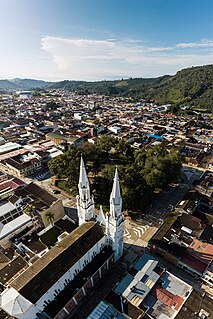
Líbano is a town and municipality in the Tolima department of Colombia. The population of the municipality was estimated 39,459 as of 2020. Along with Honda, Tolima, Líbano is the seat of the Roman Catholic Diocese of Líbano–Honda.

San Juan de Rioseco is a municipality and town of Colombia in the department of Cundinamarca with a population of about 10,000 people. It lies in mountainous terrain in the coffee land at an altitude of about 4,000 feet, high above the Magdalena River, on the western slope of Colombia's eastern cordillera about 60 miles from Bogotá by car. On a clear day the snow-capped peaks of four volcanos in the central cordillera can be seen in the distance to the west.
Los Nevados National Natural Park is a national park located in the Cordillera Central of the Colombian Andes. The park surrounds the northern volcanic complex formed by Nevado del Ruiz, Nevado del Tolima, Nevado de Santa Isabel, the paramillos of Cisne, Santa Rosa and Quindío and the Cerro Bravo and Cerro Machín.

San Ignacio del Sara is a town in the Santa Cruz department in the lowlands of the South American Andes state of Bolivia.

Las Minas is a municipality in the Mexican state of Veracruz, located 28 kilometres (17 mi) northeast of the state capital Xalapa.


