
The Arctic Archipelago, also known as the Canadian Arctic Archipelago, is an archipelago lying to the north of the Canadian continental mainland, excluding Greenland and Iceland.
The Gatineau Hills are a geological formation in Canada that makes up part of the southern tip of the Canadian Shield, and acts as the northern shoulder of the Ottawa Valley. They are also the foothills of the Laurentian Mountains which stretch east through Quebec, beginning north of Montreal and joining up with others into Vermont and New Hampshire.
Naranjito is a municipality in the Honduran department of Santa Bárbara. It is 920 meters above sea level.

Falan is a town and municipality in the Tolima department of Colombia. Falan was founded before 1539, by the Guandecas and Pomponáes tribes. It was discovered by Spanish Baltazar Maldonado in 1539. The population of the municipality was 17,251 as of the 1993 census. The total area of the municipality is 238 km². Most workers work in agriculture although some do logging or mining. The altitude is 930 meters above sea level.
Amansie Central District is one of the forty-three districts in Ashanti Region, Ghana. Originally it was formerly part of the then-larger Amansie East District in 1988, until the western part of the district was split off by a decree of president John Agyekum Kufuor on 12 November 2003 to create Amansie Central District; thus the remaining part has been retained as Amansie East District. The district assembly is located in the southern part of Ashanti Region and has Jacobu as its capital town.

Peder is a village and municipality in Košice-okolie District in the Kosice Region of eastern Slovakia.

Santa Lucía is a municipality and town in the Colombian department of Atlántico. The town is located on the north bank of the Dique Canal.

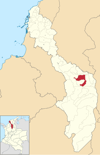
Achí is one of the 46 municipalities of the Bolívar department in the Caribbean Region of Colombia. It is crossed by the Cauca River and borders the Sucre department in the so-called Momposina Depression.
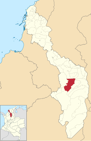
Barranco de Loba is a town and municipality located in the Bolívar Department, northern Colombia.
Tiquisio is a town and municipality located in the Bolívar Department, northern Colombia.

Sevilleja de la Jara is a municipality located in the province of Toledo, Castile-La Mancha, Spain. According to the 2006 census (INE), the municipality has a population of 0 inhabitants.Y no tienen agua

Villaeles de Valdavia is a municipality located in the province of Palencia, Castile and León, Spain. According to the 2004 census (INE), the municipality has a population of 74 inhabitants.
Langayo is a municipality located in the province of Valladolid, Castile and León, Spain. According to the 2004 census (INE), the municipality has a population of 398 inhabitants.
Olmos de Peñafiel is a municipality located in the province of Valladolid, Castile and León, Spain. According to the 2004 census (INE), the municipality has a population of 80 inhabitants.

San Martín de Valvení is a municipality located in the province of Valladolid, Castile and León, Spain. According to the 2004 census (INE), the municipality has a population of 105 inhabitants.

Velliza is a municipality located in the province of Valladolid, Castile and León, Spain. According to the 2004 census (INE), the municipality has a population of 149 inhabitants.

Caudiel is a municipality in the comarca of Alto Palancia, Castellón, Valencia, Spain.
Riidaku is a village in Märjamaa Parish, Rapla County in northwestern Estonia. Between 1991–2017 the village was located in Raikküla Parish.
Kumbungu is a town in the Kumbungu District of the Northern Region of Ghana. Kumbungu is the capital of Kumbungu district. As of 2010, fertility rate in Kumbungu stood at 3.6 and had a total population of 39,341 with an almost equal ratio of females to males. Kumbungu has a market center that comes off every sixth day.
Hassi El Ferid is a town and commune in the Kasserine Governorate, Tunisia. As of 2004 it had a population of 4 711. It is 35 km from Kasserine and 75 from Gafsa.
This page is based on this
Wikipedia article Text is available under the
CC BY-SA 4.0 license; additional terms may apply.
Images, videos and audio are available under their respective licenses.


