Rioblanco

Last updated
Rioblanco
Municipality and town
Rioblanco.jpg
View of Rioblanco
Flag of Rioblanco (Tolima).svg
Escudo Rioblanco.jpg
Colombia - Tolima - Rioblanco.svg
Location of the municipality and town of Rioblanco in the Tolima Department of Colombia.
CountryFlag of Colombia.svg  Colombia
Department Tolima Department
Government
  mayorDelcy Esperanza Isaza
Area
  Total1,443 km2 (557 sq mi)
Elevation
900 m (3,000 ft)
Population
 (Census 2018 [1] )
  Total19,090
Time zone UTC-5 (Colombia Standard Time)

Rioblanco is a town and municipality in the Tolima department of Colombia. The population of the municipality was 19,090 as of the 2018 census. [1]

Climate

Inírida has a tropical rainforest climate (Köppen Af) with heavy rainfall except for the period from June to September.

Climate data for Rioblanco (Relator), elevation 1,200 m (3,900 ft), (1981–2010)
MonthJanFebMarAprMayJunJulAugSepOctNovDecYear
Mean daily maximum °C (°F)27.2
(81.0)
27.7
(81.9)
27.5
(81.5)
27.7
(81.9)
27.9
(82.2)
28.3
(82.9)
28.6
(83.5)
29.4
(84.9)
29.4
(84.9)
28.0
(82.4)
26.8
(80.2)
26.8
(80.2)
27.9
(82.2)
Daily mean °C (°F)22.5
(72.5)
22.7
(72.9)
22.7
(72.9)
22.9
(73.2)
23.0
(73.4)
23.1
(73.6)
23.1
(73.6)
23.5
(74.3)
23.6
(74.5)
22.9
(73.2)
22.4
(72.3)
22.3
(72.1)
22.9
(73.2)
Mean daily minimum °C (°F)18.1
(64.6)
18.2
(64.8)
18.3
(64.9)
18.3
(64.9)
18.5
(65.3)
18.4
(65.1)
18.1
(64.6)
18.3
(64.9)
18.3
(64.9)
18.2
(64.8)
18.2
(64.8)
18.2
(64.8)
18.2
(64.8)
Average precipitation mm (inches)214.7
(8.45)
194.8
(7.67)
238.8
(9.40)
285.2
(11.23)
226.7
(8.93)
111.7
(4.40)
88.1
(3.47)
80.3
(3.16)
137.2
(5.40)
293.3
(11.55)
257.4
(10.13)
237.8
(9.36)
2,353.3
(92.65)
Average precipitation days181719201915141315212320212
Average relative humidity (%)78777878787774707176808076
Source: Instituto de Hidrologia Meteorologia y Estudios Ambientales [2]

Related Research Articles

<span class="mw-page-title-main">Cajamarca, Tolima</span> Municipality and town in Tolima Department, Colombia

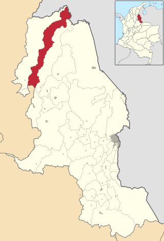
Cajamarca is a town and municipality in the Tolima Department of Colombia. The population of the municipality was 17,309 as of the 2018 census. The municipality has two populated centres, the town centre of Cajamarca and the locality of Anaime. It is located along the Pan-American Highway.

<span class="mw-page-title-main">Coyaima</span> Municipality and town in Tolima Department, Colombia

Coyaima is a town and municipality in the Tolima department of Colombia. The population of the municipality was 27,733 as of the 2005 census.

<span class="mw-page-title-main">Prado, Tolima</span> Municipality and town in Tolima Department, Colombia

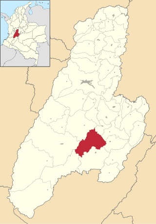
Prado is a municipality in the Tolima department of Colombia. The population of the municipality was 9,291 as of the 1993 census.

<span class="mw-page-title-main">San Antonio, Tolima</span> Municipality and town in Tolima Department, Colombia

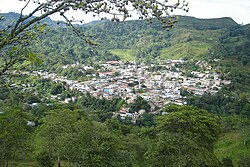
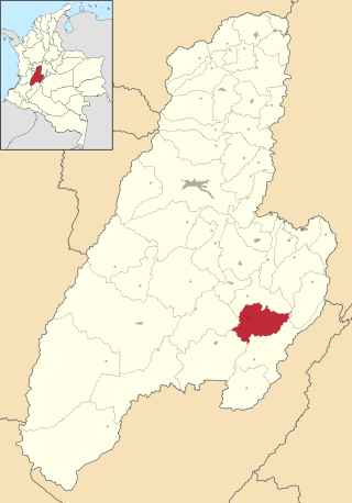
San Antonio is a municipality in the Tolima department of Colombia. The population of the municipality was 16,282 as of the 1993 census.

<span class="mw-page-title-main">Fredonia, Antioquia</span> Municipality and town in Antioquia Department, Colombia

Fredonia is a town and municipality in the Colombian department of Antioquia. It is part of the sub-region of Southwestern Antioquia. According to the 2018 census, the population comprises 18,790 people.

<span class="mw-page-title-main">Valdivia, Antioquia</span> Municipality and town in Antioquia Department, Colombia

Valdivia is a town and municipality in Antioquia Department, Colombia. Part of the subregion of Northern Antioquia, its population was 11,511 at the 2018 census.

<span class="mw-page-title-main">Venecia, Antioquia</span> Municipality and town in Antioquia Department, Colombia

Venecia is a town and municipality in Antioquia Department, Colombia. According to the 2018 census, the population comprised 10,280 people.

<span class="mw-page-title-main">San Rafael, Antioquia</span> Municipality and town in Antioquia Department, Colombia

San Rafael is a town and municipality in Antioquia Department, Colombia. Part of the subregion of Eastern Antioquia.

<span class="mw-page-title-main">Juan de Acosta</span> Municipality and town in Caribbean, Colombia

Juan de Acosta is a municipality and town in the Colombian department of Atlántico.

<span class="mw-page-title-main">Caimito, Sucre</span> Municipality and town in Sucre Department, Colombia

San Juan de Caimito, also known as Caimito. Is a town and municipality located in the Sucre Department, northern Colombia.

<span class="mw-page-title-main">Colosó</span> Municipality and town in Sucre Department, Colombia

Colosó is a town and municipality located in the Sucre Department, northern Colombia.

<span class="mw-page-title-main">Convención</span> Municipality and town in Norte de Santander Department, Colombia

Convención is a Colombian municipality located in the department of North Santander.It is considered as the largest producer of panela in the department. Account, according to figures estimated by the DANE, with a population of 16,605 inhabitants. It is located at 1,076 meters above sea level and its climate is temperate.

<span class="mw-page-title-main">La Virginia</span> Municipality and town in Risaralda Department, Colombia

La Virginia (Spanish pronunciation:[laβiɾˈxinja] is a town and municipality in the Department of Risaralda, Colombia. About 50 km away from the capital Pereira. In 2023 the town had an estimated population of 28,488.

<span class="mw-page-title-main">La Sierra, Cauca</span> Municipality and town in Cauca Department, Colombia

La Sierra is a town and municipality in the Cauca Department, Colombia.

<span class="mw-page-title-main">Tello, Huila</span> Municipality and town in Huila Department, Colombia

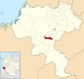
Tello is a town and municipality in the Huila Department, Colombia. It is characterized by its extensive plain between the Magdalena River and the foot of the Cordillera Oriental mountain range up to its peaks, with the Fortalecillas and Villavieja rivers located nearby. Its territorial extension is 589 km², its altitude is 575 meters above sea level and its climate is warm with an average temperature of 26°C.

<span class="mw-page-title-main">Caicedonia</span> Municipality and town in Valle del Cauca Department, Colombia

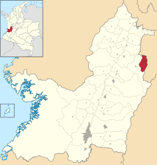
Caicedonia is a town and municipality located in the Department of Valle del Cauca, Colombia, situated about 172 km from the capital Cali. Founded in 1910 by Daniel Gutierrez, Juan Bautista Angely and a group of settlers from Antioquia, Caldas, and Tolima, it was named after Lisandro Caicedo and became a municipality in 1923. Mostly mountainous, its economy is based on agriculture and commerce, its main exports are corn, coffee, sugarcane and bananas. Given its location on the border with the Quindío Department, only 35 km from that department's capital, Armenia, Caicedonia belongs ethnographically and culturally to the Paisa region.

<span class="mw-page-title-main">Sabero</span> Place in Castile and León, Spain

Sabero is a village in the province of León, Castile and León, in north-western Spain. According to the 2019 census (INE), the municipality has a population of 1,140 inhabitants.

<span class="mw-page-title-main">Terradillos de Esgueva</span> Municipality and town in Castile and León, Spain

Terradillos de Esgueva is a municipality and town located in the province of Burgos, Castile and León, Spain. According to the 2022 census (INE), the municipality has a population of 69 inhabitants.

<span class="mw-page-title-main">Torremocha de Jarama</span> Municipality in Community of Madrid, Spain

Torremocha de Jarama is a municipality of the Community of Madrid, Spain.

Imuris Municipality is a municipality in the Mexican state of Sonora in north-western Mexico.

References

  1. 1 2 "Censo Nacional de Población y Vivienda 2018" (in Spanish). Retrieved 23 April 2020.
  2. "Promedios Climatológicos 1981–2010" (in Spanish). Instituto de Hidrologia Meteorologia y Estudios Ambientales. Archived from the original on 15 August 2016. Retrieved 17 June 2024.

3°30′N75°50′W / 3.500°N 75.833°W / 3.500; -75.833