Cumaribo

Last updated

Cumaribo
town
Flag of Cumaribo (Vichada).svg
Escudo de Cumaribo.svg
Colombia - Vichada - Cumaribo.svg
Location of Cumaribo in Vichada
Colombia location map.svg
Red pog.svg
Cumaribo
Location in Colombia
Coordinates: 04°26′00″N69°48′00″W / 4.43333°N 69.80000°W / 4.43333; -69.80000
Country Colombia
Region Orinoquía
Department Vichada
Foundation1959
Government
   Mayor Aldemar Gomez Gonzalez
Area
  Total65.193 km2 (25.171 sq mi)
Population
 (2010)
  Total23,990
  Density370/km2 (950/sq mi)
Time zone UTC-5
Postal code
991001
Demonym cumaribense
Climate Am
Website
cumaribo-vichada.gov.co/
*

Cumaribo is a town and municipality located in the Department of Vichada, Republic of Colombia. Cumaribo was founded by Jose Nicolino Mattar in 1959.

Contents

In 2005 the municipality had an estimated total population of 28,718 inhabitants, 4,312 of these living in the head of the municipality or urban area. The municipality has 74,000 kmª, one of the largest municipalities in Colombia.

Geography

The municipality of Cumaribo borders to the north with the other three municipalities of the Department of Vichada; La Primavera, Puerto Carreño and Santa Rosalia; to the east with the Bolivarian Republic of Venezuela; to the south with the Department of Guainía; and to the west with the departments of Meta and Guaviare.

Cumaribo is within the Orinoquia Region of Colombia part of the Llanos plains that cover part of Colombia and the Bolivarian Republic of Venezuela. Three-quarters of the total area of the municipality of Cumaribo is savanna and the rest is covered by jungle with some small mounts including the Mount Vichada, Mount Mona, Mount Matavenia and Mount Guaripa. [1]

There are three important rivers basins within the range of the municipality; the Orinoco River, the Meta River and the Guaviare River. The Meta river flows into the Orinoco river and the Guaviare river is the main current for the Muro, Uva and Mataven rivers. There are also two main lakes within the municipality; the Lake Caimán and the Lake Sesema. [1]

Climate

Cumaribo has a tropical monsoon climate (Köppen Am) with heavy rainfall in all months except January and February. Temperatures are consistently very warm to hot – between 27 and 30 °C (80.6 and 86.0 °F) throughout the year [1] – and humidity very high.

Climate data for Cumaribo
MonthJanFebMarAprMayJunJulAugSepOctNovDecYear
Mean daily maximum °C (°F)32.5
(90.5)
32.8
(91.0)
31.8
(89.2)
30.1
(86.2)
28.9
(84.0)
28.3
(82.9)
28.1
(82.6)
28.7
(83.7)
29.5
(85.1)
29.9
(85.8)
30.2
(86.4)
31.2
(88.2)
30.2
(86.3)
Daily mean °C (°F)27.2
(81.0)
27.6
(81.7)
27.3
(81.1)
26.4
(79.5)
25.7
(78.3)
25.2
(77.4)
25.0
(77.0)
25.3
(77.5)
25.9
(78.6)
26.1
(79.0)
26.4
(79.5)
26.8
(80.2)
26.2
(79.2)
Mean daily minimum °C (°F)21.9
(71.4)
22.4
(72.3)
22.8
(73.0)
22.7
(72.9)
22.5
(72.5)
22.1
(71.8)
21.9
(71.4)
21.9
(71.4)
22.3
(72.1)
22.3
(72.1)
22.6
(72.7)
22.4
(72.3)
22.3
(72.2)
Average rainfall mm (inches)38.2
(1.50)
69.9
(2.75)
129.6
(5.10)
278.4
(10.96)
339.4
(13.36)
411.3
(16.19)
403.6
(15.89)
297.5
(11.71)
277.1
(10.91)
302.7
(11.92)
241.0
(9.49)
132.2
(5.20)
2,920.9
(114.98)
Average rainy days6710182223232118181712195
Average relative humidity (%)72707382878888878584837982
Mean monthly sunshine hours 235.6203.2173.6135.0120.9108.0124.0133.3153.0170.5186.0220.11,963.2
Mean daily sunshine hours 7.67.25.64.53.93.64.04.35.15.56.27.15.4
Source: [2]

History

Cumaribo was officially founded by colonizers led by Jose Nicolino Mattar in 1959 but was inhabited previously by indigenous peoples such as the Guahibo.

Colombian armed conflict

The area has been under the influence of the Revolutionary Armed Forces of Colombia (FARC) guerrilla group due to the large production of coca leaves in the region and difficult access for the Military of Colombia. Tomás Medina Caracas, a prominent FARC commander in charge of the illegal drug trade for this organization was killed on 1 September 2007 in a Colombian Army military operation in eastern Colombia within the municipality of Cumaribo near the border with Venezuela. [3]

Demography

According to a census of 2001, the population at the head of the municipality was of 1055 inhabitants, 534 males, 521 females. Children between 0–14 years old was of 418 of which 206 were male and 212 female. Young adults between 15–24 years old is of 208 of which 95 were male and 113 female. Adults between the ages of 25 and 49 years old was of 358 of which 186 were male and 172 female. 49 and older were 71 people of which 47 were male and 24 female. More than half of the population were colonizers, 35% indigenous and a 15% mestizos. [4]

Indigenous reserves in Cumaribo

The municipality of Cumaribo has some 38 indigenous reserves. [4] The indigenous are predominantly the Guahibo people, Curripaco and Piapoco peoples pertaining to the Arawak language family, and the Cuiva, Desana, puinave and Saliva peoples. [5]

  1. Santa Teresita del Tuparro*
  2. Tomo Bebery
  3. El Merey
  4. San Luis del Tomo
  5. La Esmeralda
  6. Valdivia
  7. Tsololoibo Matatu
  8. Muco Guarrojo
  9. Rawaneruba
  10. Saracure
  11. Únuma
  12. Concordia
  13. Barranco Lindo
  14. Corocora
  15. Palomas Carpintero
  16. Guaco
  17. Chocón
  18. Laguna Colorada
  19. Cali
  20. Minitas
  21. Morocoto-Buenavista-Manajuare
  22. Giro
  23. Yurí
  24. Cumaral
  25. Barranquito – Laguna Colorada
  26. Caño Bocón
  27. Laguna Anguilla – La Macarena
  28. Sejalito – San Benito
  29. Lagunas Negra y Cacao
  30. Berrocal – Ajota
  31. Matavén – Fruta
  32. Caño Zama
  33. Atana Pirariame
  34. Equa Guarracañá
  35. Bajo Vichada
  36. Aiwa Cuna Tsepajibo
  37. Caño Cavasi
  38. Guacamayas.

Related Research Articles

<span class="mw-page-title-main">Orinoco</span> River in Venezuela and Colombia

The Orinoco is one of the longest rivers in South America at 2,250 kilometres (1,400 mi). Its drainage basin, sometimes known as the Orinoquia, covers 989,000 km2 (382,000 sq mi), with 76.3 percent of it in Venezuela and the remainder in Colombia. It is the fourth largest river in the world by discharge volume of water. The Orinoco River and its tributaries are the major transportation system for eastern and interior Venezuela and the Llanos of Colombia. The environment and wildlife in the Orinoco's basin are extremely diverse.

<span class="mw-page-title-main">Caño Limón–Coveñas pipeline</span>

The Caño Limón – Coveñas pipeline is a crude oil pipeline in Colombia from the Caño Limón oilfield in the municipalities of Arauca and Arauquita in Arauca Department on the border of Venezuela to Coveñas on Colombia's Caribbean coastline. It is jointly owned by the state oil firm Ecopetrol, and U.S. company Occidental Petroleum. The pipeline is 780 kilometres (480 mi) long.

<span class="mw-page-title-main">Arauca Department</span> Department of Colombia

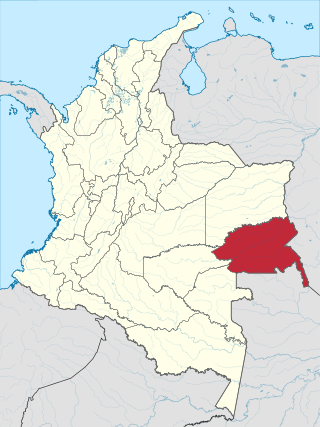
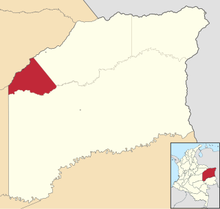
Arauca is a department of Eastern Colombia located in the extreme north of the Orinoco Basin of Colombia, bordering Venezuela. The southern boundary of Arauca is formed by the Casanare and Meta Rivers, separating Arauca from the departments of Casanare and Vichada. To the west, Arauca borders the department of Boyacá. The Caño Limón oil fields located within Arauca account for almost a third of the Colombian oil output. Its capital is the town of Arauca.

<span class="mw-page-title-main">Guainía Department</span> Department of Colombia

Guainía is a department of Eastern Colombia. It is in the east of the country, bordering Venezuela and Brazil. Its capital is Inírida. In 1963 Guainía was split off from Vaupés department. The northern part and the Inírida River are included in the Orinoco basin; the rest is part of the Amazon basin. The Guaviare River is the main area of colonization; many colonos come from the Colombian Andean zone, most of them from Boyacá. They are followed by the llaneros, people from the Eastern plains (Llanos). The population is mainly composed of Amerindians, and the largest ethnic groups are the Puinaves and the curripacos. There are a total of 24 ethnic groups in the department; many of them speak four Indigenous languages besides Spanish and Portuguese.

<span class="mw-page-title-main">Vichada Department</span> Department of Colombia

Vichada Department is a department of the Republic of Colombia in South America. Vichada is located in the eastern plains of Colombia, in the Orinoquía Region within the Orinoco river basin bordering the Bolivarian Republic of Venezuela to the north and east. To the north the department also borders with Arauca Department, to the northwest with Casanare Department, to the west with Meta Department, to the southwest narrowly bordering with Guaviare Department and to the south with Guainía Department. The department is the second largest in Colombia and scarcely populated in comparison to other departments.

<span class="mw-page-title-main">Llanos</span> Tropical grassland ecoregion in Colombia and Venezuela

The Llanos is a vast tropical grassland plain situated to the east of the Andes in Colombia and Venezuela, in northwestern South America. It is an ecoregion of the tropical and subtropical grasslands, savannas, and shrublands biome.

<span class="mw-page-title-main">Puerto Carreño</span> Consolidated Capital City | Municipality in Orinoquía, Colombia

Puerto Carreño, translation English: Puerto Carreno, lit.'Port Carreno' is the departmental capital city, and a municipality combined of the department of Vichada in the Llanos of Colombia located on the Orinoco River. Puerto Carreño is best-known as a tourist gateway to hundreds of adventure, ecological and sustainable tourism destinations, it is well-known for peacock bass fishing on the Vita River, Indigenous artisans from the Orinoquia, as a river port trade center, and as a frontier settlement that has become the capital of the second largest department (province) in Colombia.

The Hiwi people inhabit the vast flatlands between the Meta and Vichada rivers in Colombia. They call themselves the “people of the savannah”. In Venezuela, the Hiwi live in the states of Apure, Guarico, Bolivar, and Amazonas. Seventeenth- and eighteenth-century historians described the Hiwi as nomadic hunter-gatherers. Their long history of violent conflict, extending well into the twentieth century, has meant dramatic changes in their way of life. Today, when the Hiwi visit criollo towns, they wear European-style clothing: shirts and pants for the men, and cotton dresses for the women. In their own villages, many continue to wear traditional loincloths made of cloth or of a vegetable bark called marima.

<span class="mw-page-title-main">Meta River</span> Tributary of the Orinoco in the Llanos of central Colombia

The Meta River is a major left tributary of the Orinoco River in eastern Colombia and southern Venezuela, South America. The Meta originates in the Eastern Ranges of the Andes and flows through the Meta Department, Colombia as the confluence of the Humea, Guatiquía and Guayuriba rivers. It flows east-northeastward across the Llanos Orientales of Colombia following the direction of the Meta Fault. The Meta forms the northern boundary of Vichada Department, first with Casanare Department, then with Arauca Department, and finally with Venezuela, down to Puerto Carreño where it flows into the Orinoco.

The Eastern Bloc of the Revolutionary Armed Forces of Colombia, from September 2010 known as Bloque Comandante Jorge Briceño, in honour of the slain guerrilla leader, was considered to be the strongest military faction of the guerrilla group. It was divided into groups of 50–400 combatants in each group, which patrolled and controlled different areas of Colombia's Eastern and Central-Eastern territory, as well as helped to carry out the killings, taxation, and arrests necessary to advance the organization's financial and political goals.

<span class="mw-page-title-main">Piaroa people</span>

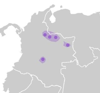
The Piaroa people, known among themselves as the Huottüja or De'aruhua, are a pre-Columbian South American indigenous ethnic group of the middle Orinoco Basin in present-day Colombia and Venezuela, living in an area larger than Belgium, roughly circumscribed by the Suapure, Parguaza (north), the Ventuari (south-east), the Manapiare (north-east) and the right bank of the Orinoco (west). Their present-day population is about 15,000 (INE 2002), with an estimated 2,500 living on the left bank of the Orinoco River, in Colombia, in several reservations between the Vichada (north) and the Guaviare (south).

Serranía de la Macarena is an isolated mountain range located in the Meta Department, Colombia. It was named after the Virgin of Hope of Macarena. The mountains are separated by about 40 km (25 mi) at their northern extreme from the East Andes. The range is orientated from north to south and is 120 km (75 mi) in length and 30 km (19 mi) wide. The highest peak reaches 2,615 m (8,579 ft) and is the highest point of the Orinoquía Region. The first national reserve in Colombia was established in the central part of the mountain range in accordance with a Congressional Law promulgated in 1948. The status of National Natural Park was designated in 1971 and the protected area encompasses 6,200 km2 (2,400 sq mi).

<span class="mw-page-title-main">Guajiboan languages</span> Macro-Arawakan language family spoken in Colombia

Guajiboan is a language family spoken in the Orinoco River region in eastern Colombia and southwestern Venezuela, a savanna region known as the Llanos.

<span class="mw-page-title-main">Guahibo people</span>

The Guahibo people are an indigenous people native to the Llanos or savanna plains in eastern Colombia and in southern Venezuela near the Colombian border. Their population was estimated at 23,772 people in 1998.

<span class="mw-page-title-main">La Primavera, Vichada</span> Place in Orinoquía, Colombia

La Primavera is a town and municipality located in the Department of Vichada, Colombia.

<span class="mw-page-title-main">Santa Rosalía, Vichada</span> Town in Orinoquía, Colombia

Santa Rosalía is a town and municipality located in the Department of Vichada, Colombia.

<span class="mw-page-title-main">Natural regions of Colombia</span>

Because of its natural structure, Colombia can be divided into six distinct natural regions. These consist of the Andean Region, covering the three branches of the Andes mountains found in Colombia; the Caribbean Region, covering the area adjacent to the Caribbean Sea; the Pacific Region adjacent to the Pacific Ocean; the Orinoquía Region, part of the Llanos plains mainly in the Orinoco river basin along the border with Venezuela; the Amazon Region, part of the Amazon rainforest; and finally the Insular Region, comprising the islands in both the Atlantic and Pacific Oceans. Colombia is located in South America.

<span class="mw-page-title-main">Timeline of the Colombian conflict</span>

This is a timeline of events related to the Colombian armed conflict.

<span class="mw-page-title-main">Joint Task Force OMEGA</span>

Joint Task Force OMEGA is a joint task force involving the Military of Colombia in support of Plan Patriota assembled with the main purpose of capturing the leaders of the Revolutionary Armed Forces of Colombia (FARC).

<span class="mw-page-title-main">Guayupe</span>

The Guayupe are an Arawak-speaking indigenous group of people in modern-day Colombia. They inhabit the westernmost parts of the department of Meta. At the time of the Spanish conquest, more than 250,000 Guayupe were living in large parts of Meta.

References

  1. 1 2 3 (in Spanish) Municipality of Cumaribo: General Information – geography Archived 9 July 2012 at archive.today
  2. "Archived copy". Archived from the original on 15 August 2016. Retrieved 21 June 2020.{{cite web}}: CS1 maint: archived copy as title (link)
  3. (in Spanish) El Tiempo: El capo de las drogas de las Farc eltiempo.com Retrieved 3 September 2007.
  4. 1 2 "Luis Angel Arango Library: Diagnóstico sociolingüístico de Cumaribo, zona de contacto indígena – Colono, Vichada" (PDF). Archived from the original (PDF) on 20 March 2009. Retrieved 23 March 2008.
  5. (in Spanish) Municipality of Cumaribo: General Information – demography Archived 9 July 2012 at archive.today