
The Arctic Archipelago, also known as the Canadian Arctic Archipelago, is an archipelago lying to the north of the Canadian continental mainland, excluding Greenland.

Monomoscoy Island is a census-designated place (CDP) in the town of Mashpee in Barnstable County, Massachusetts, United States. At the 2010 census, the CDP had a total population of 147.
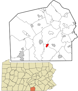
Lake Heritage is a census-designated place (CDP) in Adams County, Pennsylvania, United States. Its population was 1,333 at the 2010 census.

Fountain Springs is a census-designated place in Butler Township, Schuylkill County, Pennsylvania, United States. The population was 100 at the 2000 census.

Rovira is a town and municipality in the Tolima department of Colombia. The population of the municipality was 21,822 as of the 1993 census.
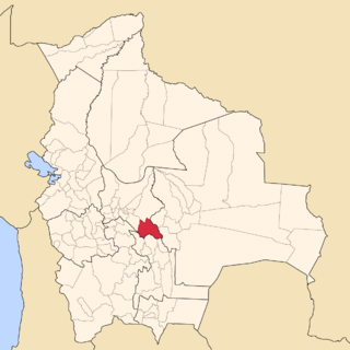
Narciso Campero is a province in the Cochabamba Department, Bolivia. Its capital is Aiquile. Aiquile lies on one transportation route between the cities of Cochabamba, Sucre and Santa Cruz.
Bass Ledge is a small barren rock in Nantucket Sound, between Martha's Vineyard and Nantucket in Massachusetts, USA. The island is east of Martha's Vineyard and west of Muskeget Island and Nantucket. It is part of Nantucket County.

Houet is one of the 45 provinces of Burkina Faso, located in its Hauts-Bassins Region. The capital of Houet is Bobo-Dioulasso. In 2019 the province has a population of 1,509,377

Casas de Ves is a municipality in Albacete, Castile-La Mancha, Spain. It has a population of 870.

Belmontejo is a municipality in Cuenca, Castile-La Mancha, Spain. It has a population of 250.
Michigan's 17th congressional district is an obsolete United States congressional district in Michigan. The first Representative to Congress elected from the 17th district, George Anthony Dondero, took office in 1933, after reapportionment due to the 1930 census. The district was dissolved following the 1990 census. The last Representative elected from the district, Sander M. Levin, was subsequently elected from the 12th district.

Corozal is a town and municipality in the Sucre Department, northern Colombia.

Trujillo is a town and municipality located in the Department of Valle del Cauca, Colombia.

Ruanes is a municipality located in the province of Cáceres, Extremadura, Spain. According to the 2006 census (INE), the municipality has a population of 70 inhabitants.

Hornillos del Camino is a municipality located in the province of Burgos, Castile and León, Spain. According to the 2004 census (INE), the municipality has a population of 70 inhabitants.
The Inglefield Mountains are a mountain range in southeastern Ellesmere Island, Nunavut, Canada. The mountain range is mostly covered by ice fields, with granitic nunataks reaching a height of 1,500 m (4,921 ft) above sea level. Rocky cliffs border the coastal areas. Like most other mountain ranges in the Canadian Arctic, the Inglefield Mountains are part of the Arctic Cordillera.

The Sikorsky S-434 is a light, turbine-powered helicopter. The S-434 is an improved development of the Schweizer S333.
Edwards Gap is a pass at about 500 metres (1,600 ft) through the Walton Mountains, southward of Mount McArthur, on Alexander Island, Antarctica. It was named by the UK Antarctic Place-Names Committee for Christopher W. Edwards, a British Antarctic Survey geologist at Stonington Island, 1973–75, who mapped this area.
This page is based on this
Wikipedia article Text is available under the
CC BY-SA 4.0 license; additional terms may apply.
Images, videos and audio are available under their respective licenses.