Anserma, Caldas

Last updated
Anserma, Caldas
Santa Ana de los Caballeros
Municipality and town
Flag of Anserma Caldas.svg
Escudo del Mariscal Jorge Robledo.svg
Colombia - Caldas - Anserma.svg
Location of the municipality and town of Anserma, Caldas in the Caldas Department of Colombia.
Colombia location map.svg
Red pog.svg
Anserma, Caldas
Location in Colombia
Coordinates: 5°14′17″N75°47′2.55″W / 5.23806°N 75.7840417°W / 5.23806; -75.7840417
CountryFlag of Colombia.svg  Colombia
Department Flag of Caldas.svg Caldas Department
Area
   Municipality and town209.1 km2 (80.7 sq mi)
  Urban
2.13 km2 (0.82 sq mi)
Elevation
1,790 m (5,870 ft)
Population
 (2020 est.) [1]
   Municipality and town36,691
  Density180/km2 (450/sq mi)
   Urban
20,876
  Urban density9,800/km2 (25,000/sq mi)
Time zone UTC-5 (Colombia Standard Time)
Website

Anserma is a town and municipality in the Colombian Department of Caldas.

Anserma was founded on August 15, 1539 by Marshal Jorge Robledo.

Climate

Climate data for Anserma (Bellavista), elevation 1,932 m (6,339 ft), (1981–2010)
MonthJanFebMarAprMayJunJulAugSepOctNovDecYear
Mean daily maximum °C (°F)21.8
(71.2)
21.9
(71.4)
21.7
(71.1)
21.6
(70.9)
21.5
(70.7)
21.4
(70.5)
21.9
(71.4)
22.0
(71.6)
21.5
(70.7)
21.2
(70.2)
20.9
(69.6)
21.0
(69.8)
21.5
(70.7)
Daily mean °C (°F)16.9
(62.4)
17.1
(62.8)
17.0
(62.6)
17.1
(62.8)
17.2
(63.0)
17.3
(63.1)
17.3
(63.1)
17.3
(63.1)
16.9
(62.4)
16.7
(62.1)
16.6
(61.9)
16.7
(62.1)
17.0
(62.6)
Mean daily minimum °C (°F)13.3
(55.9)
13.5
(56.3)
13.7
(56.7)
13.8
(56.8)
13.8
(56.8)
13.5
(56.3)
13.1
(55.6)
13.1
(55.6)
13.1
(55.6)
13.4
(56.1)
13.4
(56.1)
13.6
(56.5)
13.4
(56.1)
Average precipitation mm (inches)99.0
(3.90)
96.0
(3.78)
159.8
(6.29)
238.1
(9.37)
208.8
(8.22)
147.4
(5.80)
134.3
(5.29)
143.5
(5.65)
178.8
(7.04)
221.7
(8.73)
180.3
(7.10)
111.5
(4.39)
1,919.2
(75.56)
Average precipitation days131217212116141418212015197
Average relative humidity (%)87868788888785858787888887
Mean monthly sunshine hours 133.3118.6108.587.0102.3117.0158.1164.3114.0102.390.0102.31,397.7
Mean daily sunshine hours 4.34.23.52.93.33.95.15.33.83.33.03.33.8
Source: Instituto de Hidrologia Meteorologia y Estudios Ambientales [2]

Related Research Articles

<span class="mw-page-title-main">Valle del Cauca Department</span> Department of western Colombia

Valle del Cauca, or Cauca Valley, is a department in western Colombia abutting the Pacific Ocean. Its capital is Santiago de Cali. Other cities such as Buenaventura, Buga, Cartago, Palmira and Tuluá have great economical, political, social and cultural influence on the department's life. Valle del Cauca has the largest number of independent towns with over 100,000 inhabitants in the country, counting six within its borders. Buenaventura has the largest and busiest seaport in Colombia, moving about 8,500,000 tons of merchandise annually.

<span class="mw-page-title-main">Cajamarca, Tolima</span> Municipality and town in Tolima Department, Colombia

Cajamarca is a town and municipality in the Tolima Department of Colombia. The population of the municipality was 17,309 as of the 2018 census. The municipality has two populated centres, the town centre of Cajamarca and the locality of Anaime. It is located along the Pan-American Highway.

<span class="mw-page-title-main">Chaparral, Tolima</span> Municipality and town in Tolima Department, Colombia

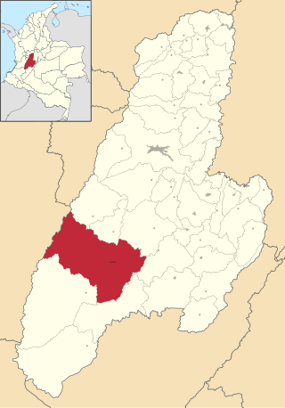
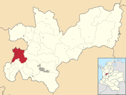
Chaparral is a town and municipality in the Tolima department of Colombia.

<span class="mw-page-title-main">Villahermosa, Tolima</span> Municipality and town in Tolima Department, Colombia

Villahermosa is a town and municipality in the Tolima department of Colombia. The population of the municipality was 12,574 as of the 1993 census. The municipality is also one of the most important coffee producers of Tolima's north.

<span class="mw-page-title-main">Barbosa, Antioquia</span> Municipality and town in Antioquia Department, Colombia

Barbosa is a town and municipality in Antioquia Department, Colombia. Situated 39 km from Medellín's downtown, it is one of the municipalities of the Metropolitan Area of the Aburrá Valley. The population was estimated to be 54,347 in 2020. It is known as the Gateway to the Northeast, famous for its lakes and streams. A traditional Pineapple Festival is held here in December and a Train Festival in the district of El Hatillo in August.

<span class="mw-page-title-main">Caldas, Antioquia</span> Municipality and town in Antioquia Department, Colombia

Caldas is a town and municipality in Antioquia Department, Colombia. Caldas is part of The Metropolitan Area of the Aburrá Valley. It is the seat of the Roman Catholic Diocese of Caldas. The population was estimated to be 83,423 in 2020.

<span class="mw-page-title-main">Fredonia, Antioquia</span> Municipality and town in Antioquia Department, Colombia

Fredonia is a town and municipality in the Colombian department of Antioquia. It is part of the sub-region of Southwestern Antioquia. According to the 2018 census, the population comprises 18,790 people.

<span class="mw-page-title-main">Támesis, Antioquia</span> Municipality and town in Antioquia Department, Colombia

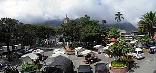
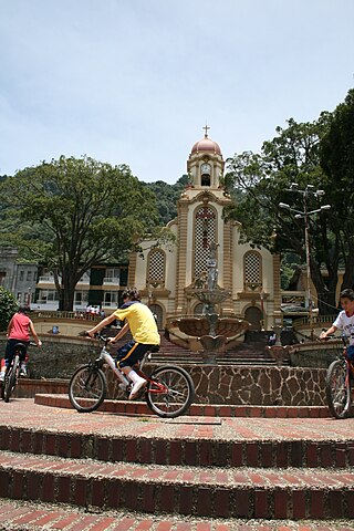
Támesis is a town and municipality in the Colombian department of Antioquia. Part of the subregion of Southwestern Antioquia. Located at an elevation of 1,638 m above sea level, it was established in 1858. The local economy is based on agriculture.

<span class="mw-page-title-main">Valdivia, Antioquia</span> Municipality and town in Antioquia Department, Colombia

Valdivia is a town and municipality in Antioquia Department, Colombia. Part of the subregion of Northern Antioquia, its population was 11,511 at the 2018 census.

<span class="mw-page-title-main">Venecia, Antioquia</span> Municipality and town in Antioquia Department, Colombia

Venecia is a town and municipality in Antioquia Department, Colombia. According to the 2018 census, the population comprised 10,280 people.

<span class="mw-page-title-main">San Rafael, Antioquia</span> Municipality and town in Antioquia Department, Colombia

San Rafael is a town and municipality in Antioquia Department, Colombia. Part of the subregion of Eastern Antioquia.

<span class="mw-page-title-main">Corozal, Sucre</span> Municipality and town in Sucre Department, Colombia

Corozal is a town and municipality in the Sucre Department, northern Colombia.

<span class="mw-page-title-main">El Carmen de Atrato</span> Municipality and town in Colombia

El Carmen de Atrato is a municipality and town in the Chocó Department, Colombia.

<span class="mw-page-title-main">Salamina, Caldas</span> Municipality and town in Caldas Department, Colombia

Salamina is a town and municipality in the Colombian department of Caldas. It is located north of the department and has a township called San Felix. It was declared a national monument and historic heritage of mankind.

<span class="mw-page-title-main">Supía, Caldas</span> Municipality and town in Caldas Department, Colombia

Supía is a town and municipality in the Colombian Department of Caldas. Located along the Colombian coffee growing axis, it was part of the "Coffee Cultural Landscape" UNESCO World Heritage Site in 2011.

<span class="mw-page-title-main">Santuario, Risaralda</span> Municipality and town in Risaralda Department, Colombia

Santuario is a town and municipality in the Department of Risaralda, Colombia. About 64 km away from the capital Pereira. In 2023 the town had an estimated population of 12,826.

<span class="mw-page-title-main">Brazacorta</span> Municipality and town in Castile and León, Spain

Brazacorta is a municipality and town located in the province of Burgos, Castile and León, Region of Ribera, Spain. According to the 2007 census (INE), the municipality had a population of 75 inhabitants.

<span class="mw-page-title-main">Pozuelo de la Orden</span> Place in Castile and León, Spain

Pozuelo de la Orden is a municipality located in the province of Valladolid, Castile and León, Spain. According to the 2004 census (INE), the municipality has a population of 75 inhabitants.

Naranjos Amatlán is a municipality in the Mexican state of Veracruz. It is located in the north zone of the state, about 402 km from the state capital Xalapa. The municipal seat is Naranjos.

References

  1. Citypopulation.de Population of Anserma municipality
  2. "Promedios Climatológicos 1981–2010" (in Spanish). Instituto de Hidrologia Meteorologia y Estudios Ambientales. Archived from the original on 15 August 2016. Retrieved 17 June 2024.

5°14′17.13″N75°47′2.55″W / 5.2380917°N 75.7840417°W / 5.2380917; -75.7840417