Puerto Triunfo is a town and municipality in Antioquia Department, Colombia. Near this town is located the Hacienda Napoles, which was once owned by Pablo Escobar.
Greenwood is a neighborhood of Louisville, Kentucky located along Cane Run Road and Greenwood Road. It is sometimes referred to by its large industrial park and shipping facility, Riverport.
San Pablo is an unincorporated community located in Costilla County, Colorado, United States. The San Luis post office (Zip Code 81152) serves San Pablo postal addresses. San Pablo is located in the Rio Culebra valley of the Sangre de Cristo Land Grant which was awarded to the family of Carlos Beaubien in 1843.
Nueva Granada is a town and municipality of the Magdalena Department in northern Colombia.

Pijiño or Pijiño del Carmen is a town and municipality of the Magdalena Department in northern Colombia.

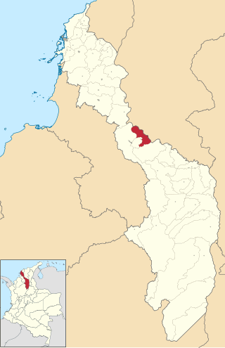
Cicuco is a town and municipality located in the Bolívar Department, northern Colombia.

Margarita is a town and municipality located in the Bolívar Department, northern Colombia.
Talaigua Nuevo is a town and municipality located in the Bolívar Department, northern Colombia.

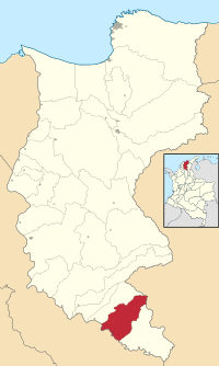
Cubarral is a town and municipality in the Meta Department, Colombia. The municipality of Guamal borders Cubarral to the north, to the west is bordered by the department of Cundinamarca, to the east by the municipality of San Martín and to the south by the municipality of El Dorado. Furthermore, According to DANE projections from the 2005 census, Cubarral would have a population of approximately 5946 people by 2015.

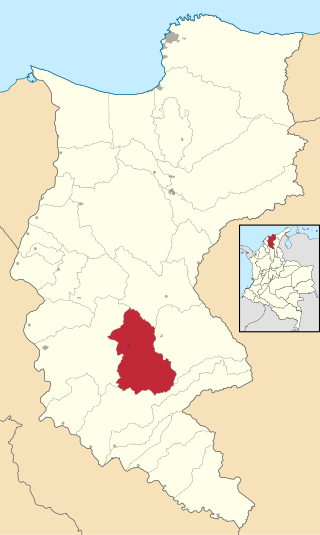
Guamal is a town and municipality in the Meta Department, Colombia.

Subachoque is a municipality and town of Colombia in the Western Savanna Province, part of the department of Cundinamarca. The municipality is situated on the Bogotá savanna with the urban centre at an altitude of 2,663 metres (8,737 ft) at a distance of 45 kilometres (28 mi) from the capital Bogotá. Subachoque is part of the Metropolitan Area of Bogotá and borders Zipaquirá, Tabio and Tenjo in the east, Zipaquirá and Pacho in the north, San Francisco and Supatá in the west and Madrid and El Rosal in the south. Subachoque is composed of 17 subdivisions: Altania, Canica Alta, Canica Baja, Cascajal, El Guamal, El Pantano, El Páramo, El Tobal, Galdámez, La Cuesta, La Pradera, La Unión, La Yegüera, Llanitos, Rincón Santo, Santa Rosa, Tibagota, El Valle.

Une is a municipality and town of Colombia in the Eastern Province, part of the department of Cundinamarca. The urban centre is located at an altitude of 2,376 metres (7,795 ft) at a distance of 43 kilometres (27 mi) from the capital Bogotá. The municipality borders Chipaque in the north, Cáqueza and Fosca in the east, Fosca and Gutiérrez in the south and Bogotá in the west.

Census Division No. 9 is a census division located within the Central Plains Region of the Province of Manitoba, Canada. Unlike in some other provinces, census divisions do not reflect the organization of local government in Manitoba. These areas exist solely for the purposes of statistical analysis and presentation; they have no government of their own.

Planura is a municipality in the west of the Brazilian state of Minas Gerais. As of 2020 the population was 12,292 in a total area of 318 km². It became a municipality in 1962.
Saint Denys River is a river in Nunavik, Quebec, Canada. It originates on Lac Silvy at 54°34′50″N76°10′50″W. It flows through Lac Marest, Lac Denys and many challenging rapids until it joins Great Whale River at 55°8′50″N77°22′34″W.
N'Goa is a small town and commune in the Cercle of San in the Ségou Region of Mali. As of 1998 the commune had a population of 7,172.
Sour El Ghozlane District is a district of Bouïra Province, Algeria.

Dainava (Varėna) is a village in Varėna district municipality, in Alytus County, in southeastern Lithuania. According to the 2001 census, the village has a population of 95 people.

Gradac is a village in the municipality of Batočina, Serbia. According to the 2011 census, the village has a population of 206 people. The Gradac Cave located in the village is part of the Cultural Heritage of Serbia list, inscribed in 1979.
Selište is a village in the municipality of Trstenik, Serbia. According to the 2002 census, the village has a population of 928 people.