
Guatemala City, known nationally also as Guate, is the capital and largest city of Guatemala. It is also a municipality capital of the Guatemala Department and the most populous urban area in Central America. The city is located in the south-central part of the country, nestled in a mountain valley called Valle de la Ermita.

Magdalena is a department of Colombia with more than 1.3 million people, located to the north of the country by the Caribbean Sea. The capital of the Magdalena Department is Santa Marta and was named after the Magdalena River. It inherited the name of one of the original nine states of the United States of Colombia that its current territory integrated.

Cesar Department or simply Cesar is a department of Colombia located in the north of the country in the Caribbean region, bordering to the north with the Department of La Guajira, to the west with the Department of Magdalena and Department of Bolivar, to the south with Department of Santander, to the east with the Department of North Santander, and further to the east with the country of Venezuela. The department capital city is Valledupar.

Barquisimeto is a city in Venezuela. Barquisimeto is located in the Central-Western Region, Venezuela. It is the capital of the state of Lara and head of Iribarren Municipality. It is an important urban, industrial, commercial and transportation center of the country, recognized as the fourth-largest city by population and area in Venezuela after Caracas, Maracaibo and Valencia.

Sonia Bazanta Vides, better known as Totó la Momposina, is a Colombian singer of Afro-Colombian and Indigenous descent. She reached international attention with the release of her 1993 album La Candela Viva on Peter Gabriel's Real World Records label. Totó accompanied Gabriel García Márquez to receive the Nobel Prize in Literature in 1982 as part of a Colombian cultural delegation performing during the award ceremony.

Magangué is a municipality of Colombia in the Department of Bolivar. The town is located in the Magdalena River; 20 km north of the mouth of the Cauca River, the Magdalena River. According to projections, the city has a population of over 198,000 inhabitants, becoming the twenty-seventh largest city in Colombia, with about 800,000 inhabitants in the Association Sabana Metropolitan, making it the eighth largest metropolitan area in Colombia. It is the second largest city of the Department, and the ninth largest of the Caribbean Region. Magangué was home to the country's largest port, now badly damaged by the problems of political corruption. It has been shown that the city has great national potential, due to its strategic location.

Mompox or Mompós, officially Santa Cruz de Mompox, is a town and municipality in northern Colombia, in the Bolívar Department. The town initially grew from its proximity to the Magdalena river and has preserved much of its colonial character. It also played an important role in the independence of America from Spain. Today, Mompox depends upon tourism, fishing, and some commerce generated by the local cattle raising. The municipality has a population of 46,408 and is adjacent to the municipalities of Pinillos and San Fernando. The historic center of Mompox was made a UNESCO World Heritage Site in 1995, owing to its preserved colonial architecture and mixture of architectural styles.

Agustín Codazzi, or Codazzi, is a city and municipality of the Department of Cesar in Colombia. It was founded in 1784 by the Spanish Captain Salvador Felix de Arias with the name of El Pueblito del Espiritu Santo but later renamed after the Italian cartographer, Giovanni Battista Agostino Codazzi, who died in this place in 1859. It is located along the Serranía del Perijá, covering some of the area pertaining to the valley of the Cesar River.

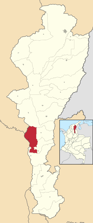
Chimichagua is a city and municipality in the central region of the Department of Cesar, Colombia. Approximately one third of the municipality of Chimichagua is water. The municipality seat lies by the Cienaga de Zapatosa marshes.

An anabranch is a section of a river or stream that diverts from the main channel or stem of the watercourse and rejoins the main stem downstream. Local anabranches can be the result of small islands in the watercourse. In larger anabranches, the flow can diverge for a distance of several or even hundreds of kilometers before rejoining the main channel.
Tamalameque is a town and municipality in the Colombian Department of Cesar. It was originally the site of a Chimila settlement, Thamara. Tamalameque is located on the right bank of the Magdalena River and borders Chimichagua and Pailitas in the north, Pelaya in the east, La Gloria in the south and in the west the departments of Bolívar and Magdalena.

Achí is one of the 46 municipalities of the Bolívar department in the Caribbean Region of Colombia. It is crossed by the Cauca River and borders the Sucre department in the so-called Momposina Depression.

Puente Aranda is the 16th location of the Capital District of the Colombian capital city, Bogotá. It is located in the center part of Bogotá. This district is mostly inhabited by lower middle and working class residents. The district was named after an old bridge in the hacienda of Juan Aranda over the "Chinúa River", now called the San Francisco River, that dates to the 16th century. Puente Aranda has 1,724 hectares of area which are almost entirely urban. This locality has more than 300,000 inhabitants, 5% of the total urban area inhabitants of Bogota.

Margarita Island, also called Mompox Island, is an inland river island in the Magdalena River, near Mompos town of interior Colombia. It is located in the Bolivar Department, on the border with the Magdalena Department in northern Colombia. With an area of 2100 to 2200 km2, it is the largest island in Colombia and the fourth largest river island in the world after the islands of Marajo, Bananal and Tupinambarana. It had a population of 117,210 in 2008.

The contribution of travel and tourism to GDP was US$5,880.3bn in 2016. Tourism generated 556,135 jobs in 2016. Foreign tourist visits were predicted to have risen from 0.6 million in 2007 to 4 million in 2017. Responsible tourism became a peremptory need for Colombia because it minimizes negative social, economic and environmental impacts and makes positive contributions to the conservation of natural and cultural heritage.

Simón Bolívar International Airport is an international airport serving the city of Santa Marta, Colombia. The airport is located 14 kilometres (8.7 mi) south of Santa Marta city center, on the shores of the Caribbean Sea. 18 kilometres (11 mi) north of the municipality of Ciénaga in Colombia.
Ciénaga de Zapatosa is a large marsh in a depression located between the Colombian departments of Cesar and Magdalena covering an area of approximately 40,000 ha and containing one million cubic meters of water. The fresh water lake in the middle of the marsh varies with the seasons from 400 to 800 square miles in extent and from 20 to 25 feet deep.
The Magdalena campaign was a military operation from late 1812 to early 1813, led by the independentists Simón Bolívar and Pierre Labatut against royalists and the crown of Spain in New Granada. The campaign resulted in the revolutionary United Provinces of New Grenada taking control of the Magdalena River, which connects the port city of Cartagena with the interior of Colombia.

Cumbia is a folkloric genre and dance from Colombia.

The Villa de Santa Cruz de Mompox was founded by Don Juan Quintero de Heredia, Adelantado of the Gobernation of Cartagena and brother of the founder of that city, Pedro de Heredia, on May 3, 1537, after fighting battles against the Kimbay tribe and defeating the Chieftain Mompoj.


