Sucre is a department in the Caribbean Region of Colombia. The department ranks 27th by area, 10,670 km2 (4,120 sq mi) and it has a population of 904,863, ranking 20th of all the 32 departments of Colombia. Sucre is bordered by the Caribbean on the northwest; by Bolívar Department on the east and by Córdoba Department on the west.
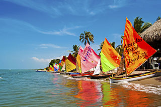
Sincelejo is the capital and largest city of the Colombian department of Sucre in the Caribbean region. It is also the capital of the department's subregion, Sabanas, and is the 25th largest city by population of the country. It is located 30 kilometers from the Caribbean Sea at the Gulf of Morrosquillo, 125 kilometers from Cartagena, and 200 kilometers from Barranquilla.

Aquitania is a town and municipality in Boyacá Department, Colombia, part of the Sugamuxi Province, a subregion of Boyaca. Aquitania borders Sogamoso, Cuítiva and Mongua in the north, Zetaquirá, San Eduardo and Páez in the south, Labranzagrande, Pajarito, Recetor and Chámeza in the east and Cuítiva, Tota, Zetaquirá and San Eduardo in the west. The urban centre is situated on the Altiplano Cundiboyacense as one of the highest towns at an altitude of 3,030 metres (9,940 ft). The town of Aquitania borders Lake Tota to the east.
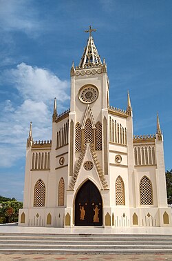
Tolú is a small town in Sucre Department, northern Colombia on the Caribbean coast. The municipality has an area of 500 km². It is named after the Tolú, one the pre-Columbian indigenous people of the North Colombia lowlands.

San Juan del Cesar is a municipality and town located in the La Guajira Department, Colombia.
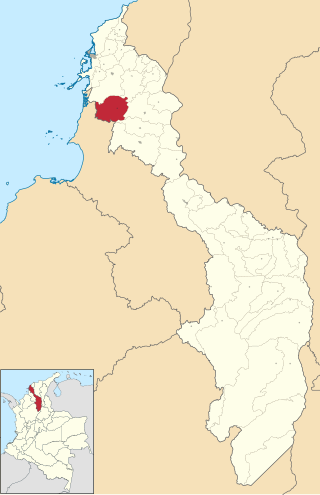
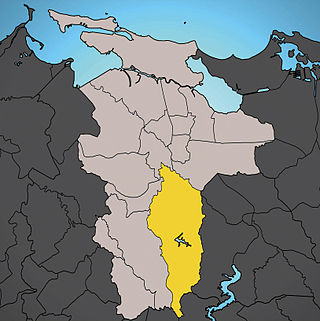
San Luis de Sincé, also knows as Sincé. Is a town and municipality located in the Department of Sucre, northern Colombia.

El Carmen de Bolívar is a municipality in the department of Bolívar, Colombia, 114 km southeast of Cartagena de Indias. It is located in the orographic system of the Montes de María, being the largest population, as well as the one that concentrates the economic and commercial movement of the subregion. It is the third most populated municipality in the department and an important agricultural center, considered "the agricultural and food pantry of the department of Bolívar" for being a great supplier to the entire department of products, especially avocado, tobacco, cocoa, banana, yam and sesame. This is how it is known as the Sweet City of Colombia since a part of its economy is based on food processing such as Chepacorinas Cookies, Coco Casadilla, Panochas, among others.

Juan de Acosta is a municipality and town in the Colombian department of Atlántico.
María La Baja is a town and municipality located in the Bolívar Department, northern Colombia.

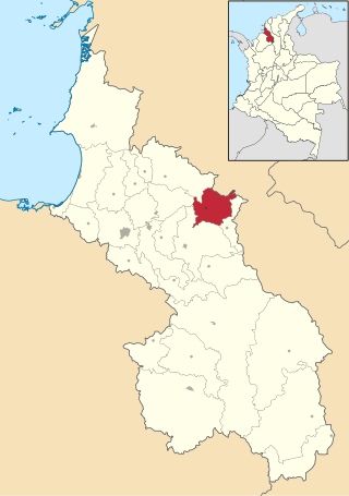
Galeras is a town and municipality located in the Sucre Department, northern Colombia. The main economic activities are agriculture and cattle raising. Galeras is 50 km away from the department's capital, Sincelejo.

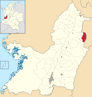
La Unión is a town and municipality located in the Sucre Department, northern Colombia.

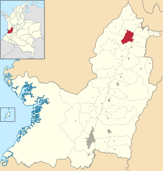
Ovejas is a town and municipality located in the Sucre Department, northern Colombia where the traditional Cumbia festival "Francisco Llirene" takes place in October.

San Juan Betulia is a town and municipality located in the Sucre Department, northern Colombia.

San Marcos is a town and municipality located in the Sucre Department, northern Colombia. It is also called "La Perla del San Jorge".
San Pedro is a town and municipality located in the Sucre Department, northern Colombia.

Tibasosa is a municipality in the Sugamuxi Province, part of the Colombian department of Boyacá. Tibasosa borders Duitama and Nobsa in the north, Nobsa and Sogamoso in the east, Firavitoba in the south and Paipa in the west.
Caicedonia is a town and municipality located in the Department of Valle del Cauca, Colombia, situated about 172 km from the capital Cali. Founded in 1910 by Daniel Gutierrez, Juan Bautista Angely and a group of settlers from Antioquia, Caldas, and Tolima, it was named after Lisandro Caicedo and became a municipality in 1923. Mostly mountainous, its economy is based on agriculture and commerce, its main exports are corn, coffee, sugarcane and bananas. Given its location on the border with the Quindío Department, only 35 km from that department's capital, Armenia, Caicedonia belongs ethnographically and culturally to the Paisa region.
Toro is a city and municipality located in the north of the department of Valle del Cauca, Colombia. The climate is warm.

Caimito is one of the 18 barrios of the municipality of San Juan, Puerto Rico located in the mountainous part of the municipality. With a land area of 5.41 square miles (14.0 km2), Caimito is the second largest barrio in the municipality of San Juan, Puerto Rico. In 2010 it had 21,825 inhabitants and a population density of 4,034.2 per sq.mi. Located in the southern part of San Juan, Caimito is bordered by barrios Tortugo and Quebrada Arenas to the west, by Monacillo to the north, by Cupey to the east and by the municipality of Caguas to the south.
Cupey is one of the 18 barrios of the municipality of San Juan, Puerto Rico located in the mountainous area of the municipality. It is the largest barrio or district in the San Juan and the third most populous with 32,833 inhabitants according to the 2020 US Census. The territorial land area of Cupey is 7.49 square miles (19.40 km2). It is bound by the municipality of Caguas to the South, by the municipality of Trujillo Alto to the East, by the barrios of Caimito and Monacillo to the West, and by the barrios of El Cinco and Sabana Llana Sur to the North. Between 1990 and 2000 Cupey had a 17.98% increase in population, more than any other barrio in San Juan.