Villavieja, Huila

Last updated
Villavieja, Huila
Municipality and town
Flag of Villavieja (Huila).svg
Colombia - Huila - Villavieja.svg
Location of the municipality and town of Villavieja, Huila in the Huila Department of Colombia.
CountryFlag of Colombia.svg  Colombia
Department Huila Department
Elevation
430 m (1,410 ft)
Time zone UTC-5 (Colombia Standard Time)

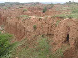
Villavieja is a town and municipality in the Huila Department, Colombia. The municipality covers most of the Tatacoa Desert. The town is built on the banks of the Magdalena River.

Church in Villa Vieja Villa vieja1.jpg
Church in Villa Vieja
Model of Mammal found in Villa Viaja Villa vieja2.jpg
Model of Mammal found in Villa Viaja
Traditional Dance Villa vieja3.jpg
Traditional Dance
Tatacoa Desert Tatacoa desert.jpg
Tatacoa Desert
The Magdalena River Magdalena at villa vieja.jpg
The Magdalena River

Climate

Climate data for Villavieja (Villavieja Ffcc), elevation 430 m (1,410 ft), (1981–2010)
MonthJanFebMarAprMayJunJulAugSepOctNovDecYear
Mean daily maximum °C (°F)34.0
(93.2)
34.3
(93.7)
33.6
(92.5)
33.2
(91.8)
33.4
(92.1)
34.2
(93.6)
34.7
(94.5)
35.6
(96.1)
35.7
(96.3)
34.0
(93.2)
32.4
(90.3)
32.7
(90.9)
34.0
(93.2)
Daily mean °C (°F)27.8
(82.0)
28.0
(82.4)
27.7
(81.9)
27.5
(81.5)
27.5
(81.5)
27.8
(82.0)
28.0
(82.4)
28.7
(83.7)
28.8
(83.8)
27.6
(81.7)
26.9
(80.4)
27.2
(81.0)
27.8
(82.0)
Mean daily minimum °C (°F)22.0
(71.6)
22.2
(72.0)
22.2
(72.0)
22.1
(71.8)
22.0
(71.6)
21.6
(70.9)
21.6
(70.9)
22.1
(71.8)
22.4
(72.3)
22.1
(71.8)
22.0
(71.6)
22.0
(71.6)
22.0
(71.6)
Average precipitation mm (inches)67.0
(2.64)
88.0
(3.46)
128.8
(5.07)
131.2
(5.17)
95.2
(3.75)
29.4
(1.16)
29.8
(1.17)
20.2
(0.80)
66.7
(2.63)
158.9
(6.26)
183.6
(7.23)
129.8
(5.11)
1,128.5
(44.43)
Average precipitation days8912141310979151512131
Average relative humidity (%)71707273726965616269757469
Source: Instituto de Hidrologia Meteorologia y Estudios Ambientales [1]
Climate data for Villavieja (San Alfonso), elevation 440 m (1,440 ft), (1981–2010)
MonthJanFebMarAprMayJunJulAugSepOctNovDecYear
Mean daily maximum °C (°F)33.6
(92.5)
34.1
(93.4)
33.8
(92.8)
33.5
(92.3)
33.9
(93.0)
35.0
(95.0)
35.4
(95.7)
36.4
(97.5)
36.2
(97.2)
34.1
(93.4)
32.5
(90.5)
32.6
(90.7)
34.3
(93.7)
Daily mean °C (°F)28.4
(83.1)
27.9
(82.2)
28.6
(83.5)
27.9
(82.2)
28.2
(82.8)
28.7
(83.7)
29.2
(84.6)
30.1
(86.2)
29.8
(85.6)
28.3
(82.9)
27.3
(81.1)
27.5
(81.5)
28.5
(83.3)
Mean daily minimum °C (°F)22.7
(72.9)
23.0
(73.4)
22.9
(73.2)
22.7
(72.9)
22.7
(72.9)
22.9
(73.2)
22.9
(73.2)
23.3
(73.9)
23.3
(73.9)
22.7
(72.9)
22.6
(72.7)
22.4
(72.3)
22.8
(73.0)
Average precipitation mm (inches)58.1
(2.29)
73.7
(2.90)
137.1
(5.40)
127.1
(5.00)
80.7
(3.18)
29.0
(1.14)
27.7
(1.09)
19.2
(0.76)
58.7
(2.31)
167.3
(6.59)
177.3
(6.98)
125.3
(4.93)
1,081.2
(42.57)
Average precipitation days71012141310979141612132
Average relative humidity (%)68666873726459575868757366
Mean monthly sunshine hours 158.1135.5127.1138.0155.0150.0164.3167.4153.0148.8135.0133.31,765.5
Mean daily sunshine hours 5.14.84.14.65.05.05.35.45.14.84.54.34.8
Source: Instituto de Hidrologia Meteorologia y Estudios Ambientales [1]
Climate data for Villavieja (San Jose), elevation 400 m (1,300 ft), (1981–2010)
MonthJanFebMarAprMayJunJulAugSepOctNovDecYear
Mean daily maximum °C (°F)33.2
(91.8)
33.6
(92.5)
33.0
(91.4)
32.6
(90.7)
32.8
(91.0)
33.6
(92.5)
34.2
(93.6)
35.2
(95.4)
35.2
(95.4)
33.3
(91.9)
31.5
(88.7)
31.7
(89.1)
33.3
(91.9)
Daily mean °C (°F)28.7
(83.7)
28.9
(84.0)
28.6
(83.5)
28.2
(82.8)
28.3
(82.9)
28.8
(83.8)
29.2
(84.6)
30.0
(86.0)
29.9
(85.8)
28.6
(83.5)
27.6
(81.7)
27.8
(82.0)
28.7
(83.7)
Mean daily minimum °C (°F)23.3
(73.9)
23.4
(74.1)
23.4
(74.1)
23.2
(73.8)
23.2
(73.8)
23.2
(73.8)
23.1
(73.6)
23.6
(74.5)
23.7
(74.7)
23.3
(73.9)
23.1
(73.6)
23.1
(73.6)
23.3
(73.9)
Average precipitation mm (inches)73.9
(2.91)
75.3
(2.96)
123.3
(4.85)
134.8
(5.31)
100.7
(3.96)
28.6
(1.13)
29.2
(1.15)
20.1
(0.79)
71.9
(2.83)
159.5
(6.28)
187.6
(7.39)
136.3
(5.37)
1,141.1
(44.93)
Average precipitation days891113139869141411124
Average relative humidity (%)68676870706661585967727266
Source: Instituto de Hidrologia Meteorologia y Estudios Ambientales [1]

3°13′N75°13′W / 3.217°N 75.217°W / 3.217; -75.217

  1. 1 2 3 "Promedios Climatológicos 1981–2010" (in Spanish). Instituto de Hidrologia Meteorologia y Estudios Ambientales. Archived from the original on 15 August 2016. Retrieved 17 June 2024.

Related Research Articles

<span class="mw-page-title-main">Huila Department</span> Department of Colombia

Huila is one of the departments of Colombia. It is located in the southwest of the country, and its capital is Neiva.

Villavieja may refer to:

La Venta is a fossil locality located in the modern departments of Tolima and Huila in Colombia. This site is one of the richest Neogene fossil assemblages in South America and represents the best-known Cenozoic fossil site outside of Argentina. It provides a glimpse of what life in the region was like before the main wave of the Great American Interchange.

<span class="mw-page-title-main">Páez, Cauca</span> Municipality and town in Cauca Department, Colombia

Paéz is a municipality in the Cauca Department, Colombia. The town of Belalcazar, is the main urban center of the Municipality. It was founded in 1905 by Valencia, Mosquera and Lemus. The town is located by the steps of the Nevado del Huila Volcano, the municipality borders to the northeast with the Tolima Department, to the west with the Huila Department, southwest with the municipality of Inza, to the west with the municipalities of Silvia and Jambalo and to the north with the municipality of Toribio covering a total area of 1,258 km2 (486 sq mi).

<span class="mw-page-title-main">Aipe</span> Municipality and town in Huila Department, Colombia

Aipe is a town and municipality in the Huila Department, Colombia. It is located on the west bank of the Magdalena River in the Central Ranges of the Colombian Andes at altitudes between 350 and 2,300 metres. Aipe borders Natagaima, Ataco and Planadas of the department of Tolima in the north and west, Villavieja and Tello in the east, and the departmental capital Neiva in the south.

<span class="mw-page-title-main">Altamira, Huila</span> Municipality and town in Huila Department, Colombia

Altamira is a town and municipality in the Huila Department, Colombia.

<span class="mw-page-title-main">Baraya</span> Municipality and town in Huila Department, Colombia

Baraya is a town and municipality in the Huila Department of Colombia.

<span class="mw-page-title-main">Hobo, Huila</span> Municipality and town in Huila Department, Colombia

Hobo is a town and municipality in the Huila Department, Colombia.

<span class="mw-page-title-main">La Argentina, Huila</span> Municipality and town in Huila Department, Colombia

La Argentina is a town and municipality in the Huila Department, Colombia.

<span class="mw-page-title-main">Nátaga</span> Municipality and town in Huila Department, Colombia

Nátaga is a town and municipality in the Huila Department, Colombia.

<span class="mw-page-title-main">Oporapa</span> Municipality and town in Huila Department, Colombia

Oporapa is a town and municipality in the Huila Department, Colombia.

<span class="mw-page-title-main">Palestina, Huila</span> Municipality and town in Huila Department, Colombia

Palestina is a town and municipality in the Huila Department, Colombia.

<span class="mw-page-title-main">Pital, Huila</span> Municipality and town in Huila Department, Colombia

Pital is a town and municipality in the Huila Department, Colombia.

<span class="mw-page-title-main">Rivera, Huila</span> Municipality and town in Huila Department, Colombia

Rivera is a town and municipality in the Huila Department, Colombia.

<span class="mw-page-title-main">Suaza</span> Municipality and town in Huila Department, Colombia

Suaza is a town and municipality in the Huila Department, Colombia.

<span class="mw-page-title-main">Tello, Huila</span> Municipality and town in Huila Department, Colombia

Tello is a town and municipality in the Huila Department, Colombia. It is characterized by its extensive plain between the Magdalena River and the foot of the Cordillera Oriental mountain range up to its peaks, with the Fortalecillas and Villavieja rivers located nearby. Its territorial extension is 589 km², its altitude is 575 meters above sea level and its climate is warm with an average temperature of 26°C.

<span class="mw-page-title-main">Teruel, Huila</span> Municipality and town in Huila Department, Colombia

Teruel is a town and municipality in the Huila Department, Colombia.

<span class="mw-page-title-main">Tesalia</span> Municipality and town in Huila Department, Colombia

Tesalia is a town and municipality in the Huila Department, Colombia.

<span class="mw-page-title-main">Timaná</span> Municipality and town in Huila Department, Colombia

Timaná is a town and municipality in the Huila Department, Colombia. The municipality is located in the south of Huila at an altitude of 1,100 metres (3,600 ft) and 166 kilometres (103 mi) southwest of the capital Neiva.

<span class="mw-page-title-main">Tatacoa Desert</span> Arid region in Colombia

The Tatacoa Desert is the second largest arid zone in Colombia after the Guajira Peninsula. It occupies more than 330 square kilometers. This region is located north of Huila Department, 38 km from the city of Neiva and 15 km (9 mi) from Natagaima in Tolima. It is renowned as a rich deposit of fossils and a tourist destination. The Tatacoa Desert has two distinctive colors: ochre in the area of Cuzco and gray in the Los Hoyos area.