
Sucre is the constitutional capital of Bolivia, the capital of the Chuquisaca Department and the 6th most populated city in Bolivia. Located in the south-central part of the country, Sucre lies at an elevation of 2,810 meters. This relatively high altitude gives the city a subtropical highland climate with cool temperatures year-round.
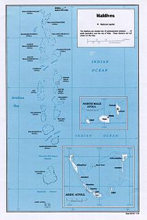
Maldives is an island country in the Indian Ocean, South Asia, south-southwest of India. It has a total land size of 298 km2 (115 sq mi) which makes it the smallest country in Asia. It consists of approximately 1,190 coral islands grouped in a double chain of 26 atolls, spread over roughly 90,000 square kilometers, making this one of the most geographically dispersed countries in the world. It has the 31st largest exclusive economic zone of 923,322 km2 (356,497 sq mi). Composed of live coral reefs and sand bars, the atolls are situated atop a submarine ridge, 960 km (600 mi) long that rises abruptly from the depths of the Indian Ocean and runs from north to south. Only near the southern end of this natural coral barricade do two open passages permit safe ship navigation from one side of the Indian Ocean to the other through the territorial waters of Maldives. For administrative purposes the Maldives government organized these atolls into twenty-one administrative divisions.

East Earl Township is a township in northeastern Lancaster County, Pennsylvania, United States. At the 2010 census the population was 6,507.
Williston is a city in Levy County, Florida, United States. As of the 2010 census it had a population of 2,768. The city was established before 1885 by J.M. Willis, who named it after himself.
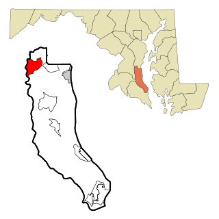
Dunkirk is a census-designated place (CDP) in Calvert County, Maryland, United States. The population was 2,521 at the 2010 census.
Le Center is a city in Le Sueur County, Minnesota, United States. The population was 2,517 at the 2020 census. It is the county seat of Le Sueur County. The Le Sueur County Courthouse and Jail are listed on the National Register of Historic Places.

East Missoula is a census-designated place (CDP) in Missoula County, Montana, United States. It is part of the 'Missoula, Montana Metropolitan Statistical Area'. The population was 2,157 at the 2010 census, an increase from its population of 2,070 in 2000.

Jourdanton is a city in and the county seat of Atascosa County, Texas, United States. The population was 3,871 at the 2010 census. It is part of the San Antonio Metropolitan Statistical Area. The Mayor is Robert "Doc" Williams. The City Manager is Lamar Schulz. The Police Chief is Eric Kaiser. The Fire Chief is Jay Fojtik.

Rose City is a city three miles east of Beaumont in Orange County, Texas, United States. The population was 502 at the 2010 census, down from 519 at the 2000 census. It is part of the Beaumont–Port Arthur Metropolitan Statistical Area.

Craigsville is a town in Augusta County, Virginia, United States. The population was 923 at the 2010 census. It is part of the Staunton–Waynesboro Micropolitan Statistical Area.

Sucre State is one of the 23 states of Venezuela. The state capital is Cumaná city. Sucre State covers a total surface area of 11,800 km2 (4,600 sq mi) and, as of the 2011 census, had a population of 896,921. The most important river in the state is the Manzanares River.

Rajpipla is a city and a municipality in the Narmada district in the Indian state of Gujarat.

The Paria Peninsula is a large peninsula on the Caribbean Sea, in the state of Sucre in northern Venezuela.

Guaranda is a town and municipality located in the Sucre Department, northern Colombia.

Majagual is a town and municipality located in the Sucre Department, northern Colombia.

Bolívar is a town and municipality in the Santander Department in northeastern Colombia.
Gololcha is one of the woredas in the Oromia Region of Ethiopia. It was part of former Gaserana Gololcha woreda what was divided for Gadera and Gololcha woredas. Part of the Bale Zone, Gaserana Gololcha is bordered on the south by Ginir, on the southwest by Sinanana Dinsho, on the west by Agarfa, on the north by the Shebelle River which separates it from the Arsi Zone, on the northeast by Legehida, and on the east by Seweyna. The administrative center for the woreda is Jara.

Campohermoso is a town and municipality in the Colombian Department of Boyacá, part of the subregion of the Lengupá Province.

Arcabuco is a town and municipality in the Ricaurte Province, part of the Colombian Department of Boyacá. Arcabuco is situated on the Altiplano Cundiboyacense with the urban centre at an altitude of 2,739 metres (8,986 ft). The municipality borders Moniquirá and Gámbita in the north, Villa de Leyva and Chíquiza in the south, Cómbita in the east and Gachantivá and Villa de Leyva in the west. The department capital Tunja is 34 kilometres (21 mi) to the south.

The New York House of Refuge was the first juvenile reformatory established in the United States. The reformatory was opened in 1824 on the Bowery in Manhattan, New York City, destroyed by a fire in 1839, and relocated first to Twenty-Third Street and then, in 1854, to Randalls Island.


