
The geography of France consists of a terrain that is mostly flat plains or gently rolling hills in the north and west and mountainous in the south and the east. Metropolitan France has a total size of 551,695 km2 (213,011 sq mi). It is the third largest country in Europe by area and the largest in Western Europe.

The Arctic Archipelago, also known as the Canadian Arctic Archipelago, is an archipelago lying to the north of the Canadian continental mainland, excluding Greenland and Iceland.
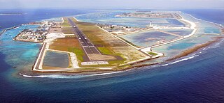
Hulhulé (ހުޅުލެ), located at 4°11′N73°32′E, is an island in the North Malé Atoll of the Maldives where the city's airport, Velana International Airport, is located. The island has no permanent population.

Castletownshend is a village about 8 km (5 mi) south-east of Skibbereen, in County Cork, Ireland. The village developed around a small 17th-century castle built by Richard Townsend, whose descendants still reside there.
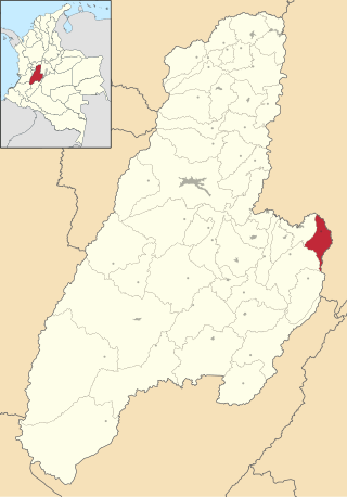
Icononzo is a municipality located in the Tolima Department in Colombia.

Cucaita is a municipality in the Central Boyacá Province, part of Boyacá Department, Colombia. The urban centre is situated on the Altiplano Cundiboyacense at a distance of 20 kilometres (12 mi) from the department capital Tunja. Cucaita borders Sora in the north, Tunja in the east and south and Samacá in the south and west.

Ráquira, is a municipality and town in Boyacá Department, Colombia, part of the subregion of the Ricaurte Province. Ráquira is situated on the Altiplano Cundiboyacense and the urban center at an altitude of 2,150 metres (7,050 ft). It borders Tinjacá and Sutamarchán in the north, Guachetá, Cundinamarca in the south, in the east Sáchica and Samacá and in the west San Miguel de Sema and Lake Fúquene.

German submarine U-280 was a Type VIIC U-boat of Nazi Germany's Kriegsmarine during World War II.

KMXA-FM is an adult contemporary radio station in Minot, North Dakota, owned by iHeartMedia, Inc. During the Christmas season "Mix 99.9" plays continuous Christmas music. The station begins playing the Christmas music the day after Thanksgiving and runs until Christmas Day.
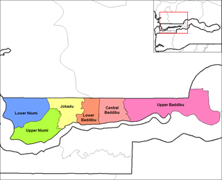
Jokadu is one of the six districts of the North Bank Division of the Gambia. In the 2013 census, it had a population of 22,132.

Chivatá is a town and municipality in the Central Boyacá Province, part of the Colombian department of Boyacá. The urban centre is situated at an altitude of 2,903 metres (9,524 ft) on the Altiplano Cundiboyacense at 5 kilometres (3.1 mi) from the department capital Tunja. It borders Oicatá, Toca and Tuta in the north, Toca and Siachoque in the east, Siachoque and Soracá in the south and Tunja in the west.

Villardiegua de la Ribera is a municipality located in the province of Zamora, Castile and León, Spain. According to the 2004 census (INE), the municipality has a population of 162 inhabitants.
Vicente Guerrero is a municipality in the Mexican state of Puebla. The capital of the commune is Santa María del Monte.

Kiisamaa is a village in Lääneranna Parish, Pärnu County in southwestern Estonia.
Ikerasak Strait is a strait in the Avannaata municipality in northwestern Greenland.
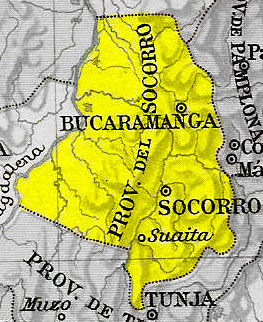
Socorro Province was one of the provinces of Gran Colombia. It belonged to the Boyacá Department which was created in 1824.

Liso Polje is a village in the municipality of Ub, Serbia. According to the 2011 census, the village has a population of 225 people.

Montarville is a provincial electoral district in the Montérégie region of Quebec, Canada that elects members to the National Assembly of Quebec. It consists of the municipalities of Boucherville and Saint-Bruno-de-Montarville, both of which are part of the urban agglomeration of Longueuil.
This page is based on this
Wikipedia article Text is available under the
CC BY-SA 4.0 license; additional terms may apply.
Images, videos and audio are available under their respective licenses.

