
The Arctic Archipelago, also known as the Canadian Arctic Archipelago, is an archipelago lying to the north of the Canadian continental mainland, excluding Greenland and Iceland.
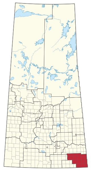
Cannington is a provincial electoral district for the Legislative Assembly of Saskatchewan, Canada. Located in the extreme southeast corner of the province, this constituency was redrawn to include the former district of Souris for the 18th Saskatchewan general election in 1975.
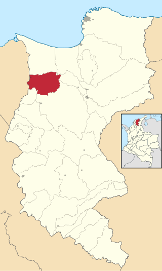
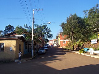
San José de la Montaña is a town and municipality in the Colombian department of Antioquia, part of the subregion of Northern Antioquia.
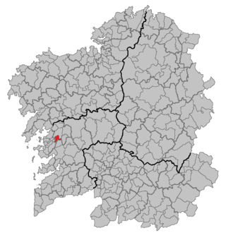
Portas is a municipality in Galicia, Spain in the province of Pontevedra.
Pleebo is a city located in Maryland County, Liberia. It is the largest city in Maryland County with a population of 22,693 in 2008.
Remolino is a town and municipality of the Colombian Department of Magdalena. Founded between 1752 and 1776 by Fernando de Mier y Guerra. Erected municipality in 1814.
Camponaraya is a village and municipality located in the region of El Bierzo. According to the 2010 census (INE), the municipality has a population of 4,230 inhabitants.

Long Mỹ is a rural district of Hậu Giang province in the Mekong Delta region of Vietnam. As of 2019 the district had a population of 84,089. The district covers an area of 259.92 km2. The district capital lies at Vĩnh Viễn town.
Porto Mauá is a municipality in the state of Rio Grande do Sul, Brazil. As of 2020, the estimated population was 2,352.
Sallé is a town in the Kouka Department of Banwa Province in western Burkina Faso. As of 2005 it had a population of 2,930.

Piikani 147, formerly Peigan 147, is an Indian reserve of the Piikani Nation in Alberta. It is located 61 km (38 mi) west of the City of Lethbridge. It has a land area of 426.992 km2 (164.863 sq mi), making it the fourth-largest Indian reserve in Canada, and lies at an elevation of 1,046 m (3,432 ft). The Canada 2011 Census reported a population of 1,217 inhabitants. It is bordered by the Municipal District of Willow Creek No. 26 on its north and east, and by the Municipal District of Pincher Creek No. 9 on its west and south. The nearest outside communities are Fort Macleod and Pincher Creek.

Béoumi Department is a department of Gbêkê Region in Vallée du Bandama District, Ivory Coast. In 2021, its population was 195,015 and its seat is the settlement of Béoumi. The sub-prefectures of the department are Ando-Kékrénou, Béoumi, Bodokro, Kondrobo, Lolobo, Marabadiassa, and N'Guessankro. It is the geographical center of the country.
Cumbers Reef is a group of rocks aligned in an arc forming the north and west parts of the Amiot Islands, off the southwest part of Adelaide Island. It was named by the UK Antarctic Place-Names Committee for Roger N. Cumbers, 3rd officer of RRS John Biscoe, 1961–62, the ship which assisted the Royal Navy Hydrographic Survey Unit in the charting of this area in 1963.
Mataruge is a village situated in Kraljevo municipality in Serbia.

German submarine U-173 was a Type IXC U-boat of Nazi Germany's Kriegsmarine during World War II.
German submarine U-538 was a Type IXC/40 U-boat of Nazi Germany's Kriegsmarine during World War II.

Washington's 24th legislative district is one of forty-nine districts in Washington state for representation in the state legislature.

Valladolid is one of the 59 constituencies represented in the Senate of Spain, the upper chamber of the Spanish parliament, the Cortes Generales. The constituency elects four senators. Its boundaries correspond to those of the Spanish province of Valladolid. The electoral system uses an open list partial block voting, with electors voting for individual candidates instead of parties. Electors can vote for up to three candidates.


