Pueblo Rico, Risaralda

Last updated
Pueblo Rico, Risaralda
Municipality and town
Flag of Pueblo Rico (Risaralda).svg
Escudoprico.jpg
Colombia - Risaralda - Pueblo Rico.svg
Location of the municipality and town of Pueblo Rico, Risaralda in the Risaralda Department of Colombia.
CountryFlag of Colombia.svg  Colombia
Department Risaralda Department
Area
[1]
  Total561 km2 (217 sq mi)
Elevation
1,560 m (5,120 ft)
Population
 (2023)
  Total12,423
  Density22/km2 (57/sq mi)
Time zone UTC-5 (Colombia Standard Time)

Pueblo Rico is a town and municipality in the Department of Risaralda, Colombia. About 97 km away from the capital Pereira. In 2023 the town had an estimated population of 12,423. [2]

Contents

History

Founded in 1904 by Hilarión Pinzón, Leandro Tamayo, Justo Grajales, Sinforoso Leyva, Bibiano Chalarca, José Terán, Luis Ángel and Segundo Ramos. In 1884 by a group of Antioqueños, from Carmen del Atrato, Chocó and it was officially founded in the year 1907. It belonged to Chocó until 1912, when it was annexed to Caldas through Law 31.

In 1925, the construction of the Cintó penal colony began, on the left bank of the San Juan River, which is now closed. Around it, in 1953, the town of Santa Cecilia emerged, which was declared a township that same year. By that time, the first Chocoan families had already reached this place. In 1940, the township of Villa Claret was established, a small hamlet formed northeast of the municipal seat. With these three population centers the Municipality of Pueblo Rico is created. [3]

Climate

Pueblo Rico has a subtropical highland climate with an average annual temperature of 20°C. [4]

Climate data for Pueblo Rico, elevation 1,530 m (5,020 ft), (1981–2010)
MonthJanFebMarAprMayJunJulAugSepOctNovDecYear
Mean daily maximum °C (°F)22.0
(71.6)
22.1
(71.8)
22.4
(72.3)
22.5
(72.5)
22.7
(72.9)
22.5
(72.5)
22.4
(72.3)
22.5
(72.5)
22.3
(72.1)
22.0
(71.6)
21.9
(71.4)
21.9
(71.4)
22.3
(72.1)
Daily mean °C (°F)18.3
(64.9)
18.3
(64.9)
18.5
(65.3)
18.7
(65.7)
18.8
(65.8)
18.7
(65.7)
18.6
(65.5)
18.5
(65.3)
18.5
(65.3)
18.3
(64.9)
18.1
(64.6)
18.2
(64.8)
18.4
(65.1)
Mean daily minimum °C (°F)16.0
(60.8)
16.1
(61.0)
16.2
(61.2)
16.6
(61.9)
16.5
(61.7)
16.2
(61.2)
15.9
(60.6)
15.8
(60.4)
15.8
(60.4)
15.7
(60.3)
15.8
(60.4)
15.9
(60.6)
16.0
(60.8)
Average precipitation mm (inches)134.3
(5.29)
122.8
(4.83)
146.0
(5.75)
217.8
(8.57)
205.9
(8.11)
194.7
(7.67)
170.7
(6.72)
160.7
(6.33)
190.9
(7.52)
257.9
(10.15)
298.4
(11.75)
184.3
(7.26)
2,284.2
(89.93)
Average precipitation days171618222422212120232419240
Average relative humidity (%)92929192929291919292939292
Mean monthly sunshine hours 127.1104.596.187.099.2105.0127.1127.190.096.1108.0117.81,285
Mean daily sunshine hours 4.13.73.12.93.23.54.14.13.03.13.63.83.5
Source: Instituto de Hidrologia Meteorologia y Estudios Ambientales [5]

Related Research Articles

<span class="mw-page-title-main">Risaralda Department</span> Department of Colombia

Risaralda is a department of Colombia. It is located in the western central of the country, in the Andean region, It is part of the Coffee axis with Caldas and Quindío. Its capital is Pereira. Risaralda is very well known for the high quality of its coffee, and a booming industry: automotive, clothes, food, trading of goods and services.

<span class="mw-page-title-main">Duitama</span> Municipality and city in Boyacá, Colombia

Duitama is a city and municipality in the department of Boyacá. It's the capital of the Tundama Province. Duitama is located 195 kilometres (121 mi) northeast of Bogotá, the capital of Colombia and 50 kilometres (31 mi) northeast of Tunja, the capital of Boyacá. In 2023 Duitama had an estimated population of 131,591.

<span class="mw-page-title-main">Montenegro, Quindío</span> Municipality and town in Quindío Department, Colombia

Montenegro is a municipality in the western part of the department of Quindío, Colombia. It is located 10 km west of the departmental capital Armenia. In 2023 it had an estimated population of 38,240.

<span class="mw-page-title-main">Dosquebradas</span> Municipality and town in Risaralda Department, Colombia

Dosquebradas is the second largest city and a municipality in the Risaralda Department, Colombia. As of 2023, with a population of approximately 225,540 inhabitants. The city is connected by the César Gaviria Trujillo Viaduct to Pereira, the capital of the department.

<span class="mw-page-title-main">Guática</span> Municipality and town in Risaralda Department, Colombia

Guática is a town and municipality in the Risaralda Department of Colombia, about 93 km away from the capital Pereira. In 2023 the town had an estimated population of 12,423.

<span class="mw-page-title-main">Circasia, Quindío</span> Municipality and town in Quindío Department, Colombia

Circasia is a municipality in the northern part of the department of Quindío, Colombia. It's located 7 km north of the department's capital Armenia. Located within the Colombian coffee growing axis, the historic center of Circasia was made part of the "Coffee Cultural Landscape" UNESCO World Heritage Site in 2011.

<span class="mw-page-title-main">Salento, Quindío</span> Municipality and town in Quindío, Colombia

Salento is a town and municipality in the north-east of the department of Quindío, Colombia. The municipality covers an area of 377.67 km2. It was the first settlement in Quindío of the modern era, and the first municipality founded in the department. The town of Salento itself is located 24 km northeast of the departmental capital Armenia. In 2023 the municipality of Salento had an estimated population of 9,748.It has a wide variety of tourist attractions including the Cocora Valley where one can find a landscape full of nature, such as the Barranquero or Momotus aequatorialis, a commonly seen bird, take ecological walks and enjoy the landscapes of this town.

<span class="mw-page-title-main">La Tebaida</span> Municipality and town in Quindío Department, Colombia

La Tebaida is a municipality in the western part of the department of Quindío, Colombia. It's located 17 km southwest of the departmental capital Armenia. In 2023 La Tebaida had an estimated population of 35,010.

<span class="mw-page-title-main">Filandia, Quindío</span> Municipality and town in Quindío, Colombia

Filandia is a town and municipality in the northern part of the department of Quindío, Colombia. It's located on the west side of Cordillera Central of the Andes mountain range running through central Colombia, 26 km north of the departmental capital Armenia. In 2023 the estimated population of Filandia was 12,596 inhabitants.

<span class="mw-page-title-main">Santa Rosa de Cabal</span> Place in Risaralda, Colombia

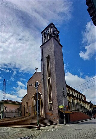
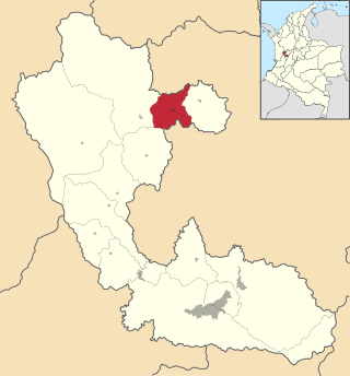
Santa Rosa de Cabal is a town and municipality in the Department of Risaralda, Colombia. About 14 km away from the capital Pereira. In 2023 the town had an estimated population of 79,840.

<span class="mw-page-title-main">Belén de Umbría</span> Municipality and town in Risaralda Department, Colombia

Belén de Umbría is a town and municipality in the Department of Risaralda, Colombia. At a distance of approximately 70 kilometers from the capital Pereira. In 2023 the town had an estimated population of 25,276.

<span class="mw-page-title-main">Marsella</span> Municipality and town in Risaralda Department, Colombia

Marsella or Marseille is a town and municipality in the Department of Risaralda in Colombia. About 30 km away from the capital Pereira. In 2023 the town had an estimated population of 17,208.

<span class="mw-page-title-main">Istmina</span> Municipality and town in Chocó Department, Colombia

Istmina is a municipality and town in the Chocó Department, Colombia. The town of Istmina was founded in 1834 by Juan Nepomuceno Mosquera, initially with the name of San Pablo. The name was changed in 1903 to Istmina, a contraction of isthmus and minas (mines), two characteristics of the area. The municipality covers 1,880 square kilometres (726 sq mi), with an average elevation of 79 metres (259 ft), and an average temperature of 26.7 °C (80 °F). Istmina is located 75 km (47 mi) from the departmental capital, Quibdó.

<span class="mw-page-title-main">Apía, Risaralda</span> Place in Risaralda, Colombia

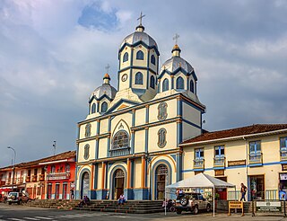
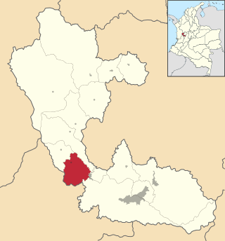
Apía is a town and municipality in the Department of Risaralda, Colombia. It's located at an elevation of 1,630 metres, about 60 km away from district capital Pereira in the valley of the Apia river. For 2023 it has approximately 12,613 inhabitants. The town has excellent views over Cerro Tatamá, which is part of Tatamá National Natural Park.

<span class="mw-page-title-main">Balboa, Risaralda</span> Municipality and town in Risaralda Department, Colombia

Balboa is a town and municipality in the Department of Risaralda, Colombia, with a distance of approximately 53 kilometers from the capital Pereira. In 2023, the town had an estimated population of 6,510.

<span class="mw-page-title-main">La Celia</span> Municipality and town in Risaralda Department, Colombia

La Celia is a town and municipality in the Department of Risaralda, Colombia. About 67 km away from the capital Pereira. In 2023 the town had an estimated population of 7,642.

<span class="mw-page-title-main">La Virginia</span> Municipality and town in Risaralda Department, Colombia

La Virginia (Spanish pronunciation:[laβiɾˈxinja] is a town and municipality in the Department of Risaralda, Colombia. About 50 km away from the capital Pereira. In 2023 the town had an estimated population of 28,488.

<span class="mw-page-title-main">Mistrató</span> Municipality and town in Risaralda Department, Colombia

Mistrato is a town and municipality in the Department of Risaralda, Colombia. About 86 km away from the capital Pereira. In 2023 the town had an estimated population of 17,527.

<span class="mw-page-title-main">Quinchía</span> Town and Municipality in Risaralda, Colombia

Quinchía, also known as Villa de los Cerros, is a town and municipality in the Department of Risaralda, Colombia. About 110 km away from the capital Pereira. In 2023 the town had an estimated population of 27,890.

<span class="mw-page-title-main">Santuario, Risaralda</span> Municipality and town in Risaralda Department, Colombia

Santuario is a town and municipality in the Department of Risaralda, Colombia. About 64 km away from the capital Pereira. In 2023 the town had an estimated population of 12,826.

References

  1. "Municipalities of Colombia". statoids. Retrieved 29 April 2020.
  2. Telefónicas, Telencuestas-Encuestas. "Cuántos habitantes tiene Pueblo Rico, Risaralda en 2023". Telencuestas (in Spanish). Retrieved 2023-09-28.
  3. Risaralda, Gobernación de (2016-09-28). "Pueblo Rico". Gobernación de Risaralda (in Spanish). Retrieved 2023-09-28.
  4. "Pueblo Rico – Risaralda un destino lleno de vida" (in Spanish). Retrieved 2023-09-28.
  5. "Promedios Climatológicos 1981–2010" (in Spanish). Instituto de Hidrologia Meteorologia y Estudios Ambientales. Archived from the original on 15 August 2016. Retrieved 17 June 2024.

5°15′N76°10′W / 5.250°N 76.167°W / 5.250; -76.167