El Castillo, Meta

Last updated

El Castillo, Meta
Municipality and town
Flag of El Castillo (Meta).svg
Escudo de El Castillo (Meta).svg
Colombia - Meta - El Castillo.svg
Location of the municipality and town of El Castillo, Meta in the Meta Department of Colombia.
CountryColombia
Department Meta Department
Elevation
530 m (1,740 ft)
Time zone UTC-5 (Colombia Standard Time)
Climate Am

El Castillo is a town and municipality in the Meta Department, Colombia.

Contents

History

The first settlers settled on the banks of the Caño Uruimes, with the passage of time this was elevated to the Category of Police Inspection of the Municipality of San Martín, under the name of Inspection of Urimes. By 1963, the name was changed to La Cal, which was again changed in 1976 when it was created as a municipality with its current name of El Castillo.

El Castillo was elevated to municipality by Ordinance No.001 of 19 February 1976. [1]

Geography

Limits

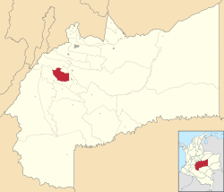
The municipality is located in the southwest of the department; in the region known as Alto Ariari

El Castillo has an average annual rainfall of 3,700 millimetres, and its average temperature is 28 °C.

Hydrography

The municipality is crossed by the Guape River to the west and the Ariari River to the east, where they join to the southeast of the municipality. To the northwest is the El Guape Lagoon. The La Cal River crosses the municipality, as do the Dulce, Embarrado, Urimes and Yamanes Rivers.

Economy

Agriculture stands out as the main source of income for the municipality, especially corn, rice, cassava, banana and passion fruit crops, as well as smaller-scale crops of bananas, avocado, guava and some citrus fruits. Livestock occupies the second sector of the municipal economy; both in the production of milk and in the production of meat. The industrial sector is not very developed, its main exponent in a corn dryer that is located within the municipal seat; there are also numerous medium and small raw material transformation companies produced in the region.

3°34′05″N73°47′02″W / 3.56806°N 73.7839°W / 3.56806; -73.7839

Related Research Articles

<span class="mw-page-title-main">Cauca Department</span> Department of Colombia

Cauca Department is a Department of Southwestern Colombia. Located in the southwestern part of the country, facing the Pacific Ocean to the west, the Valle del Cauca Department to the north, Tolima Department to the northeast, Huila Department to the east, and Nariño Department to the south. Putumayo and Caqueta Departments border the southeast portion of Cauca Department as well. It covers a total area of 29,308 km2 (11,316 sq mi), the 13th largest in Colombia. Its capital is the city of Popayán. The offshore island of Malpelo belongs to the department. It is located in the southwest of the country, mainly in the Andean and Pacific regions plus a tiny part (Piamonte) in the Amazonian region. The area makes up 2.56% of the country.

<span class="mw-page-title-main">El Castillo, Nicaragua</span> Place in Río San Juan Department, Nicaragua

El Castillo is a municipality located on the Río San Juan in the Río San Juan Department of Nicaragua. The settlement of what would eventually become the municipality of El Castillo began in 1673, when construction of the Fortaleza de la Limpia Pura e Inmaculada Concepción, was begun. The village of El Castillo eventually grew around the fortress, which continued to be strategically important to the Captaincy General of Guatemala until the late 18th century.

<span class="mw-page-title-main">Municipalities of Colombia</span> Decentralized subdivisions of the Republic of Colombia

The municipalities of Colombia are decentralized subdivisions of the Republic of Colombia. Municipalities make up most of the departments of Colombia with 1,122 municipalities (municipios). Each one of them is led by a mayor (alcalde) elected by popular vote and represents the maximum executive government official at a municipality level under the mandate of the governor of their department which is a representative of all municipalities in the department; municipalities are grouped to form departments.

<span class="mw-page-title-main">Formiga, Minas Gerais</span> Place in Southeast, Brazil

Formiga is a municipality in central-west Minas Gerais state, Brazil. The population of the municipality in 2020 is 67,822. The area of the municipality is 1,504 km2. It is located in the statistical meso-region of Centro-Oeste de Minas and the statistical micro-region of Formiga. It was founded in 1839.

<span class="mw-page-title-main">São Francisco de Goiás</span> Municipality in Central-West, Brazil

São Francisco de Goiás is a municipality in central Goiás state, Brazil.

<span class="mw-page-title-main">Fundación</span> Place in Colombia, South America

Fundación is a town and municipality of the Colombian Department of Magdalena. Its people are known as Fundanenses. The primary economic activity is livestock-raising, for production of both meat and milk. Other crops are: corn, yuca, oranges, bananas, beans, sesame, sorghum, rice, tomatoes, and tobacco. There is also artisanal fishing.

<span class="mw-page-title-main">Socorro, Santander</span> Municipality and town in Santander Department, Colombia

Socorro is a town and municipality in the Santander Department in northeastern Colombia. It was founded in 1681 by José de Archila and José Díaz Sarmiento. The town was very influential in the history of Colombia. There began the revolt of the Comuneros of 1781 against the oppression of Spanish rule.

<span class="mw-page-title-main">Acacías</span> Municipality and town in Meta Department, Colombia

Acacias is a town and municipality in the Meta Department, Colombia. This town is one of the most important municipalities in terms of population and economy, together with La Macarena, Granada and the capital city of Villavicencio. The name of the city is due to the acacia flowers that used to bloom in the region. It is considered one of the municipalities of Meta with more progress and development.

<span class="mw-page-title-main">Cubarral</span> Municipality and town in Meta Department, Colombia

Cubarral is a town and municipality in the Meta Department, Colombia. The municipality of Guamal borders Cubarral to the north, to the west is bordered by the department of Cundinamarca, to the east by the municipality of San Martín and to the south by the municipality of El Dorado. Furthermore, According to DANE projections from the 2005 census, Cubarral would have a population of approximately 5946 people by 2015.

<span class="mw-page-title-main">Granada, Meta</span> Municipality and town in Meta Department, Colombia

Granada is a town and municipality in the Meta Department, Colombia. The municipality has an area of 348.3 square kilometres (134 sq mi) and a population of 68,876. The municipality is located between 3° 26" latitude north and 73° 43" longitude west and between 372 and 410 metres above sea level. The daily mean air temperature varies between 24 and 25.6 °C. Annual rainfall is between 2,400 and 2,800 millimetres. The town is connected to Santa Fé de Bogotá along a 180 kilometres (110 mi) road and lies about 80 kilometres or 50 miles from the regional capital Villavicencio.

<span class="mw-page-title-main">Puerto Gaitán</span> Municipality and town in Meta Department, Colombia

Puerto Gaitán is a town and municipality in the Meta Department, Colombia.

<span class="mw-page-title-main">El Cerrito, Valle del Cauca</span> Municipality and town in Valle del Cauca Department, Colombia

El Cerrito is a town and municipality located in the Department of Valle del Cauca, Colombia. This is one of the 42 municipalities of the department.

<span class="mw-page-title-main">Suba, Bogotá</span> Locality of Bogotá in Bogotá D.C., Colombia

Suba is the 11th locality of Bogotá, capital of Colombia. It is located in the northwest of the city, bordering to the north the municipality of Chía in Cundinamarca, to the west the municipality of Cota, to the east the locality Usaquén and to the south the localities Engativá and Barrios Unidos. This district is inhabited by residents of all social classes.

<span class="mw-page-title-main">Planura</span> Town and municipality in the state of Minas Gerais, Brazil

Planura is a municipality in the west of the Brazilian state of Minas Gerais. As of 2020 the population was 12,292 in a total area of 318 km2. It became a municipality in 1962.

<span class="mw-page-title-main">Bocaiúva</span> Town in Brazil

Bocaiuva is a Brazilian municipality located in the northwest of the state of Minas Gerais. Its population as of 2020 was 50,256 people living in a total area of 3,232 km2. The city belongs to the mesoregion of North of Minas and to the microregion of Bocaiuva. It became a municipality in 1890.

<span class="mw-page-title-main">Pimenta, Minas Gerais</span> Brazilian municipality located in the center of the state of Minas Gerais

Pimenta is a Brazilian municipality located in the center of the state of Minas Gerais. Its population as of 2020 was 8,688 people living in a total area of 415 km². The city belongs to the meso-region of Oeste de Minas and to the micro-region of Formiga. It became a municipality in 1948.

<span class="mw-page-title-main">Claraval</span> Brazilian municipality

Claraval is a Brazilian municipality located in the southwest of the state of Minas Gerais.

<span class="mw-page-title-main">São José da Barra</span> Brazilian municipality located in the southwest of the state of Minas Gerais

São José da Barra is a Brazilian municipality located in the southwest of the state of Minas Gerais. Its population as of 2020 was 7,480 people living in a total area of 312 km2. The city belongs to the meso-region of Sul e Sudoeste de Minas and to the micro-region of Passos. It became a municipality in 1948. The important hydroelectric plant of Furnas is located here.

<span class="mw-page-title-main">San Rafael, Veracruz</span> Municipality in Veracruz, Mexico

San Rafael Municipality is a municipality located in the Mexican state of Veracruz. The municipal seat is San Rafael, Veracruz.

<span class="mw-page-title-main">El Castillo (village)</span> Comarca and village in Río San Juan Department, Nicaragua

El Castillo is a village of about 1,500 people situated on the southern bank of the Río San Juan in southern Nicaragua. It is one of 27 comarcas of the municipality of El Castillo, a subdivision of the Río San Juan Department. The village is situated approximately 6 kilometers from the border with Costa Rica, at the Raudal del Diablo rapids of the San Juan River. The site on which the village of El Castillo is built was initially established in 1673 as a Spanish fortification to defend against pirate attacks upon the city of Granada. The settlement of El Castillo and its fortress continued to be strategically important to the Captaincy General of Guatemala until the late 18th century.

References

  1. Medellín Becerra, Jorge Alejandro; Fajardo Rivera, Diana. El Castillo. Diccionario de Colombia (2005 edición). p. 335. ISBN 958-04-8561-5