Cravo Norte

Last updated
Cravo Norte
Municipality and town
Flag of Cravo Norte (Arauca).svg
Escudo de Cravo Norte.svg
Colombia - Arauca - Cravo Norte.svg
Location of the municipality and town of Cravo Norte in the Arauca Department of Colombia
CountryFlag of Colombia.svg  Colombia
Department Arauca Department
Founded1538
Government
  MayorJavier Esneider Triana Mujica
Area
   Municipality and town5,301 km2 (2,046.73 sq mi)
Elevation
124 m (406.82 ft)
Population
 (2015)
   Municipality and town3,331
  Density0.63/km2 (1.63/sq mi)
   Urban
2,319
Time zone UTC-5 (Colombia Standard Time)
Climate Aw
Website www.cravonorte-arauca.gov.co

Cravo Norte is a town and municipality in the Arauca Department, Colombia. It is thought to have been founded in 1538 by the Jesuit missionary Joseph Gumilla. The first census was conducted in May 1797 and counted a population of 205. [1]

Climate

Cravo Norte has a tropical monsoon climate (Köppen Am) with little rainfall from December to March and heavy to very heavy rainfall from April to November.

Climate data for Cravo Norte
MonthJanFebMarAprMayJunJulAugSepOctNovDecYear
Mean daily maximum °C (°F)33.2
(91.8)
34.4
(93.9)
34.4
(93.9)
32.5
(90.5)
30.6
(87.1)
29.5
(85.1)
29.4
(84.9)
30.3
(86.5)
31.0
(87.8)
31.5
(88.7)
31.9
(89.4)
32.2
(90.0)
31.7
(89.1)
Daily mean °C (°F)27.3
(81.1)
28.2
(82.8)
28.7
(83.7)
27.8
(82.0)
26.7
(80.1)
25.9
(78.6)
25.8
(78.4)
26.3
(79.3)
26.8
(80.2)
27.1
(80.8)
27.4
(81.3)
27.2
(81.0)
27.1
(80.8)
Mean daily minimum °C (°F)21.5
(70.7)
22.0
(71.6)
23.0
(73.4)
23.2
(73.8)
22.8
(73.0)
22.4
(72.3)
22.2
(72.0)
22.3
(72.1)
22.6
(72.7)
22.7
(72.9)
22.9
(73.2)
22.2
(72.0)
22.5
(72.5)
Average rainfall mm (inches)17.9
(0.70)
20.8
(0.82)
61.0
(2.40)
188.9
(7.44)
318.4
(12.54)
403.9
(15.90)
410.0
(16.14)
279.4
(11.00)
266.5
(10.49)
256.9
(10.11)
146.0
(5.75)
41.6
(1.64)
2,411.3
(94.93)
Average rainy days1241017191916151283126
Source 1: IDEAM [2]
Source 2: Climate-Data.org [3]

Related Research Articles

<span class="mw-page-title-main">Belmira</span> Municipality and town in Antioquia Department, Colombia

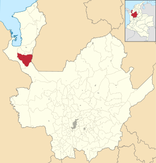
Belmira is a town and municipality in the northern subregion of the Colombian department of Antioquia. It is approximately 62 km from the city of Medellin. It lies at an altitude of 2,550 m above sea level.

<span class="mw-page-title-main">Carepa</span> Municipality and town in Antioquia Department, Colombia

Carepa is a town and municipality in Antioquia Department, Colombia. Carepa is part of the Urabá Antioquia sub-region.

<span class="mw-page-title-main">Caramanta</span> Municipality and town in Antioquia Department, Colombia

Caramanta is a town and municipality in the Colombian department of Antioquia. It is part of the sub-region of Southwestern Antioquia.

<span class="mw-page-title-main">Chigorodó</span> Municipality and town in Antioquia Department, Colombia

Chigorodó is a town and municipality in Antioquia Department, Colombia. It is part of the Urabá Antioquia sub-region.

<span class="mw-page-title-main">Gómez Plata</span> Municipality and town in Antioquia Department, Colombia

Gómez Plata is a town and municipality in the Colombian department of Antioquia. It is part of the subregion of Northern Antioquia. The population was 8,235 at the 2018 census.

<span class="mw-page-title-main">Heliconia, Antioquia</span> Municipality and town in Antioquia Department, Colombia

Heliconia is a town and municipality in Antioquia Department, Colombia.

<span class="mw-page-title-main">La Unión, Antioquia</span> Municipality and town in Antioquia Department, Colombia

La Unión is a town and municipality in the Colombian department of Antioquia. The population was 20,769 at the 2018 census. It is part of the subregion of Eastern Antioquia.

<span class="mw-page-title-main">San Juan de Urabá</span> Municipality and town in Antioquia Department, Colombia

San Juan de Urabá is a town and municipality in the Colombian department of Antioquia. It is part of the Urabá Antioquia sub-region.

<span class="mw-page-title-main">Briceño, Antioquia</span> Municipality and town in Antioquia Department, Colombia

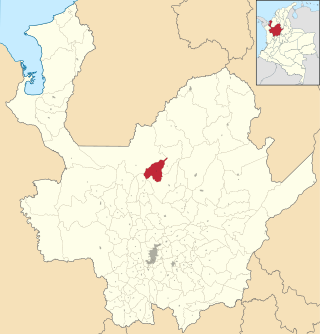
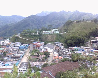
Briceño is a town and municipality in Antioquia Department, Colombia. Part of the subregion of Northern Antioquia, it lies at an altitude of 1,200 m above sea level.

<span class="mw-page-title-main">Barranco de Loba</span> Municipality and town in Bolívar Department, Colombia

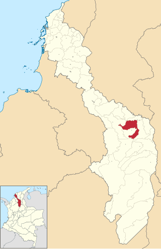
Barranco de Loba is a town and municipality located in the Bolívar Department, northern Colombia.

<span class="mw-page-title-main">San Jacinto del Cauca</span> Municipality and town in Bolívar Department, Colombia

San Jacinto del Cauca is a town and municipality located in the Bolívar Department, northern Colombia.

<span class="mw-page-title-main">Toledo, Norte de Santander</span> Municipality and town in Norte de Santander Department, Colombia

Toledo is a Colombian municipality and town located in the department of North Santander. It is on the border with Boyacá Department and has natural gas development in the township of Gibraltar. In August 2011 the Gibraltar to Bucaramanga gas pipeline was completed.

<span class="mw-page-title-main">Tauramena</span> Municipality and town in Casanare Department, Colombia

Tauramena is a town and municipality in the Department of Casanare, Colombia.

<span class="mw-page-title-main">Pensilvania, Caldas</span> Municipality and town in Caldas Department, Colombia

Pensilvania is a town and municipality in the Colombian Department of Caldas.

<span class="mw-page-title-main">Quípama</span> Municipality and town in Boyacá, Colombia

Quípama is a town and municipality in the Colombian Department of Boyacá, part of the subregion of the Western Boyacá Province.

<span class="mw-page-title-main">Campohermoso</span> Municipality and town in Boyacá Department, Colombia

Campohermoso is a town and municipality in the Colombian Department of Boyacá, part of the subregion of the Lengupá Province.

<span class="mw-page-title-main">Restrepo, Meta</span> Municipality and town in Meta Department, Colombia

Restrepo is a town and municipality in the Meta Department, Colombia.

<span class="mw-page-title-main">Magüí Payán</span> Municipality and town in Nariño Department, Colombia

Magüí Payán is a town and municipality in the Nariño Department, Colombia.

<span class="mw-page-title-main">Nariño, Nariño</span> Municipality and town in Nariño Department, Colombia

Nariño is a town and municipality in the Nariño Department, Colombia.

Limones is a corregimiento in Barú District, Chiriquí Province, Panama. It has a land area of 53.8 square kilometres (20.8 sq mi) and had a population of 1,040 as of 2010, giving it a population density of 19.3 inhabitants per square kilometre (50/sq mi). Its population as of 1990 was 974; its population as of 2000 was 948.

References

  1. [ permanent dead link ]
  2. "Data". www.ideam.gov.co. Archived from the original on 2016-08-15. Retrieved 2020-08-22.
  3. "Climate: Cravo Norte". Climate-Data.org. Retrieved August 22, 2020.

6°18′N70°12′W / 6.300°N 70.200°W / 6.300; -70.200