Maicao

Last updated • 8 min readFrom Wikipedia, The Free Encyclopedia
Maicao
Maikau (Wayuu)
مايكاو (Arabic)
Municipality and city
Maicaolaguajira.jpg
Flag of Maicao.svg
Escudo de Maicao.svg
Colombia - La Guajira - Maicao.svg
Location of the town and municipality of Maicao in the Department of La Guajira.
Colombia location map.svg
Red pog.svg
Maicao
Coordinates: 11°22′40″N72°14′29″W / 11.37778°N 72.24139°W / 11.37778; -72.24139
Country Colombia
Region Caribbean
Department La Guajira
FoundationJune 27, 1927
Government
   Mayor Mohamad Jaafar Dasuki Hajj
Area
   Municipality and city1,769 km2 (683 sq mi)
  Urban
21.94 km2 (8.47 sq mi)
Elevation
52 m (171 ft)
Population
 (2020 est.) [1] [2]
   Municipality and city185,072
  Density100/km2 (270/sq mi)
   Urban
118,889
  Urban density5,400/km2 (14,000/sq mi)
Demonym Maicaeros
Time zone UTC-5
Area code 57 + 5
Climate Aw
Website Official website (in Spanish)
*

Maicao (Wayuu: mai-ka-u) is a city and municipality in the Department of La Guajira, northern Republic of Colombia. It is located 76 km from Riohacha, the capital of the department and is the second largest urban center near the border with Venezuela, after the city of Cúcuta.

Contents

The city was founded on June 27, 1927 by Colonel Rodolfo Morales and Tomás Curvelo Iguarán, on behalf of the Department of Magdalena in the middle of the Wayuu people territory. [3] During the 1970s Maicao became a commercial hub due to an oil boom in Venezuela and the flow of contraband present in the Guajira peninsula.

Etymology

The name of Maicao comes from the Wayunaiki: mai-ka-u which means "Land of the Maize. [4]

Geography

Maicao is located in the Guajira Peninsula, the northernmost part of South America and on the border of the Guajira desert.

The municipality of Maicao borders to the north with the municipalities of Uribia and Manaure; to the east with the Venezuela; to the south with the municipality of Albania and to the west with the municipality of Riohacha covering a total area of 1,782 km2 and at altitude over sea level of 52 m.

Climate

Climate in the municipality of Maicao varies from hot semi-arid (Köppen BSh) in the north to tropical savanna (Aw) in the south. [5] There are typically two rainy seasons and two dry seasons. The average temperature throughout the year ranges from 27 to 29 °C (81 to 84 °F).

Climate data for Maicao (Esc Agr Carraipia), elevation 118 m (387 ft), (1981–2010)
MonthJanFebMarAprMayJunJulAugSepOctNovDecYear
Mean daily maximum °C (°F)30.3
(86.5)
31.3
(88.3)
32.3
(90.1)
32.7
(90.9)
32.9
(91.2)
32.9
(91.2)
33.6
(92.5)
34.2
(93.6)
33.0
(91.4)
31.8
(89.2)
30.7
(87.3)
30.0
(86.0)
32.3
(90.1)
Daily mean °C (°F)25.8
(78.4)
26.1
(79.0)
26.7
(80.1)
27.2
(81.0)
27.7
(81.9)
27.9
(82.2)
28.1
(82.6)
28.2
(82.8)
27.6
(81.7)
27.0
(80.6)
26.5
(79.7)
26.0
(78.8)
27.1
(80.8)
Mean daily minimum °C (°F)21.5
(70.7)
21.8
(71.2)
22.4
(72.3)
23.0
(73.4)
23.4
(74.1)
23.7
(74.7)
23.7
(74.7)
23.7
(74.7)
23.1
(73.6)
22.5
(72.5)
22.5
(72.5)
21.8
(71.2)
22.8
(73.0)
Average precipitation mm (inches)19.3
(0.76)
14.9
(0.59)
20.8
(0.82)
72.3
(2.85)
161.1
(6.34)
69.5
(2.74)
42.6
(1.68)
92.8
(3.65)
160.7
(6.33)
214.3
(8.44)
215.4
(8.48)
92.7
(3.65)
1,176.4
(46.31)
Average precipitation days4437116591316169102
Average relative humidity (%)79757374787775747983858478
Mean monthly sunshine hours 223.2186.3186.0144.0145.7183.0217.0210.8174.0176.7180.0198.42,225.1
Mean daily sunshine hours 7.26.66.04.84.76.17.06.85.85.76.06.46.1
Source: Instituto de Hidrologia Meteorologia y Estudios Ambientales [6]

History

Maicao was inhabited by the Wayuu people prior to the arrival of the Spanish. The Wayuu gave strong resistance to the Spanish conquest, remaining rebellious until the early 20th century. Maicao was officially founded on June 27, 1927 by Colonel Rodolfo Morales and Tomás Curvelo Iguarán, on behalf of the Department of Magdalena in the middle of the Wayuu people territory. [3]

One of the first families to settle in the area were those of José Domingo Boscán and Manuel Palacio López, who settled near the Venezuelan border between the road that connects Riohacha and Maraicaibo, in addition to the fact that this area had relatively fertile land. [7] In 1927, several wells and windmills were built in the area by a German firm. [7] In 1929, the township (Spanish: Corregimiento) of Maicao was created, following population growth. [8] By 1940, Maicao had 500 inhabitants. [7]

The indigenous Wayuu managed contraband trading routes through Maicao arriving from Aruba, Curaçao, Venezuela and other Caribbean Sea territories mostly coffee, alcohol, tobacco and weapons among other taxable articles. During the 1970s Maicao became a commercial hub due to an oil boom in Venezuela and the flow of contraband present in the Guajira peninsula. The commercial boom attracted Arab and other Middle Eastern immigrants most of whom established in Maicao as merchants, establishing another culture in the area.

Arab Migration

Due to Maicao's proximity to the Venezuelan border, it attracted a number of immigrants to the municipality, in addition to its free port characteristics, and in the 1970's it attracted a number of Arab immigrants from the Levant. In 1989, the Colombo-Arab College Dar el Arkam was created. [9] The migrants settled in the center of Maicao, where one of them, José Abuchaibe of Palestinian origin, built the largest building in the municipality, which is the Hotel Don Juan. [10] In 1997 Middle Eastern immigrants built the Mosque of Omar Ibn Al-Khattab, one of the largest mosques in South America.

Colombian armed conflict period

The marijuana bonanza in the outskirts of the Sierra Nevada de Santa Marta mountains also introduced another factor to the culture of the region. Marimberos or drug dealers initiated exports of numerous illegal drug trade to the United States and Europe where there was a high demand for drugs. Opulence in certain urban areas became notable, including a Ferraris collection by Lafaurie-González clan (Eduardo, Iván and Fernando Lafaurie-Gonzalez) and their bunker style houses in Maicao and Riohacha. [11]

During the 1980s and 1990s the internal Colombian armed conflict between the government of Colombia and numerous revolutionary groups mainly the Revolutionary Armed Forces of Colombia (FARC) and the National Liberation Army began to affect the municipality of Maicao. Extortions, kidnappings and assassinations became a common practice. The situation worsened due to the deflation of the Venezuelan economy and the trade decrease, as well as crackdowns on contraband by the Colombian government.

In 1991 was given special customs status in 1991 in order to spur job growth. The government's intent was to allow raw materials to enter the zone untaxed, have workers there turn them into finished product, and then re-export the finished goods outside Colombia. The law allowed for a certain amount of goods to pass from Maicao into the Colombian interior, but only if they were declared to customs officials and duty was paid on them. Cigarettes however moved outside the Maicao special customs zone "duty not paid" and from there into the black market.

Maicao became subject to royalties coming from the exploitation of coal in the Cerrejon coal mine, however municipal administrations have been subject to widespread corruption and royalties have been temporarily suspended. The culture of avoiding paying taxes has created in numerous occasions tensions between the locals and the government, including burning down the local tax bureau office DIAN in protest for confiscating large amounts of contraband. The municipality also suffered a problem of displaced people due to the internal armed conflict and deficiencies in education and health. [12]

Hezbollah ties

According to FBI investigators who allegedly told Rio de Janeiro's O Globo in late October 2001 that in addition to the Triborder Region, a focal point of terrorism in South America was Maicao, described as an Islamic community of approximately 4,670 vacation spot for orthodox Islamics and the largest and best organized Islamic community in Colombia with a minority Shiites reportedly more closely associated with the Muslim fundamentalist concept. [13] The report said that there were cells of the radical group Hezbollah and that it controlled up to 70 percent of the local commerce. "The merchants from there make contributions equivalent to 10 percent and even up to 30 percent of their profits. And those responsible for the fund send the money via banks in Maracaibo in Venezuela, and in Panama. [13]

The Department of Administrative Security (Departamento de Seguridad Administrativa―DAS) shut down a clandestine radio station in Maicao on August 15, 1997, for broadcasting Hezbollah propaganda, and a couple of arrests for money laundering, Maicao's Muslim community reportedly has had few contacts with the law. Nevertheless, it is known that the black market for weapons and money laundering in Maicao and neighboring Zulia State in Venezuela is well established. [13]

Hezbollah cells based within Maicao have used drug trafficking and contraband networks to launder funds that were later used to finance terrorist operations worldwide. [14]

Modern Times

On March 19, 2000 the town of Albania segregated some 425 km2 from Maicao and became a municipality. The municipality of Maicao lost a large area over the coal mine section decreasing the royalties percentage intended for the region. [12] [15]

Economy

Ninety percent of Maicao's economy depends on commerce and the rest is mainly in the service sector, in addition to a small percentage in the manufacturing industry. According to statistics from the Chamber of Commerce of the Municipality it is estimated that there are 1300 registered commercial stores. [10] In 1992, the Special Customs Regime Zone of Maicao, Uribia and Manaureo was established in 1992 to regulate trade in the area. [10] One of the products grown in Maicao is Ahuyama, better known as Cucurbita moschata, this vegetable is processed into flour from this municipality and marketed in European countries. [16]

Culture

Transportation

The municipality of Maicao had one now closed airstrip, La Majayura Airport, which has been closed, but may reopen. [17] The city is now served by Jorge Isaacs Airport, which is located 40 kilometres (25 mi) in the southwest. It is also still a major transportation hub between Venezuela and Colombia.

Land transportation is served by a two-lane single-road highway, crossing the municipality of Maicao from Rio Hacha towards Venezuela and another from the town of Maicao south towards Valledupar. While much of the trade is legitimate, there is also a great deal of smuggling and contraband. [18]

Heritage Sites

Maicao has several tourist sites such as the Monumento a la Identidad, a sculpture made by Cartagena artist Alfredo Tatis Benzo, this monument is also known as "El Abuelo de las Barbas del Maíz" ( lit. 'The Grandfather of the Corn Beards') in reference to how Maicao received its name. [19] In addition there is the Plaza Bolivar of Maicao, it had a statue of Simon Bolivar that collapsed in 2021 from strong breezes, this statue had remained for more than 34 years in the square. [20] In May 2022, a new statue was put up again, this time by the artist of the municipality, Vespaciano Ruiz Pichón. [20] Another religious site in the municipality is the San José Church, which is the patron saint of the municipality. [21]

Nature Reserves

Maicao along the municipality of Albania has the Montes de Oca  [ es ] Natural Reserve, the reserve is in the township of Carraipía, south of Maicao.. This protected area has at least 14400 hectares, and is the source of water for part of the population of Maicao. [22] According to the Autonomous Regional Corporation of La Guajira (Spanish: Corporación Autónoma Regional de La Guajira) there are approximately 200 types of plants and 177 species of birds, Montes de Oca contain endangered forest species such as Guayacán. [22]

Related Research Articles

<span class="mw-page-title-main">Viceroyalty of New Granada</span> Viceroyalty of the Spanish Empire (1717–1822)

The Viceroyalty of the New Kingdom of Granada, also called Viceroyalty of New Granada or Viceroyalty of Santa Fe, was the name given on 27 May 1717 to the jurisdiction of the Spanish Empire in northern South America, corresponding to modern Colombia, Ecuador, Panama and Venezuela. Created in 1717 by King Felipe V, as part of a new territorial control policy, it was suspended in 1723 for financial problems and was restored in 1739 until the independence movement suspended it again in 1810. The territory corresponding to Panama was incorporated later in 1739, and the provinces of Venezuela were separated from the Viceroyalty and assigned to the Captaincy General of Venezuela in 1777. In addition to those core areas, the territory of the Viceroyalty of New Granada included Guyana, Trinidad and Tobago, southwestern Suriname, parts of northwestern Brazil, and northern Peru. A strip along the Atlantic Ocean in Mosquito Coast was added by the Royal Decree of 20 November 1803, but the British battled for administrative control.

<span class="mw-page-title-main">Riohacha</span> District and city in Caribbean, Colombia

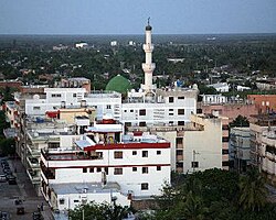
Riohacha is a city in the Riohacha Municipality in the northern Caribbean Region of Colombia by the mouth of the Ranchería River and the Caribbean Sea. It is the capital city of the La Guajira Department. It has a sandy beach waterfront.

<span class="mw-page-title-main">Guajira Peninsula</span> Geographic feature in northeastern Colombia and northwestern Venezuela

The Guajira Peninsula is a peninsula in northern Colombia and northwestern Venezuela in the Caribbean. It is the northernmost peninsula in South America and has an area of 25,000 km2 (9,700 sq mi) extending from the Manaure Bay (Colombia) to the Calabozo Ensenada in the Gulf of Venezuela (Venezuela), and from the Caribbean to the Serranía del Perijá mountains range.

<span class="mw-page-title-main">Wayuu people</span> Indigenous South American ethnic group of the Guajira Peninsula

The Wayuu are an Indigenous ethnic group of the Guajira Peninsula in northernmost Colombia and northwest Venezuela. The Wayuu language is part of the Arawakan language family.

<span class="mw-page-title-main">La Guajira Department</span> Department of Colombia

La Guajira is a department of Colombia. It occupies most of the Guajira Peninsula in the northeast region of the country, on the Caribbean Sea and bordering Venezuela, at the northernmost tip of South America. The capital city of the department is Riohacha.

<span class="mw-page-title-main">Manaure, La Guajira</span> Town in Caribbean, Colombia

Manaure or Salinas de Manaure is a town and municipality located in the Colombian Department of La Guajira. Manaure's main economic activity is the exploitation of the vast amounts of salt in the area.

<span class="mw-page-title-main">Ranchería River</span> River in Colombia

The Ranchería River is a river located in northern La Guajira Department, Colombia. Born in the Sierra Nevada de Santa Marta southern steps flows south, abruptly turns northeast and then north where it finally flows into the Caribbean Sea. It is the main river of La Guajira Department and has great significance for the Wayuu people.

<span class="mw-page-title-main">Barrancas, La Guajira</span> Town in Caribbean, Colombia

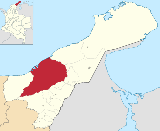
Barrancas is a town and municipality of the Colombian Department of La Guajira. The municipality of Barrancas is located to the left margin of the Ranchería River in a valley formed between the Sierra Nevada de Santa Marta mountains and the Serranía del Perijá. Barrancas has a total area of 742 km2 and at 40 meters over sea level. The average temperature is 28 °C throughout the year and distances from the capital of the Department of La Guajira, Riohacha. It became a municipality in 1892.

<span class="mw-page-title-main">Fonseca, La Guajira</span> Municipality and town in Caribbean, Colombia

Fonseca is a municipality located in the Colombian Department of La Guajira. The town celebrates the Festival del Retorno in honor of St Augustine with religious celebrations, vallenato music events and others.

<span class="mw-page-title-main">Uribia, La Guajira</span> Town in Caribbean, Colombia

Uribia is a town and municipality of the La Guajira department of Colombia. It is the youngest municipality of this Department since the year 2000. Northern Zone of the Cerrejón coal mines are located in this municipality. The municipality also contains the Serranía de Macuira mountain range which is an isolated low altitude mountain range in the middle of La Guajira Desert. One third of this mountain range is also a National Natural Park of Colombia.

<span class="mw-page-title-main">Albania, La Guajira</span> Town in Caribbean, Colombia

Albania is a town and municipality of the Colombian Department of La Guajira. Is the youngest municipality of this Department along with the town of Uribia and others, created on March 19, 2000. Albania neighbours and exclusive enclosed camp site for the Cerrejón coal mine workers and their families, named Mushaisa.

<span class="mw-page-title-main">Dibulla, La Guajira</span> Town in Caribbean, Colombia

Dibulla is a town and municipality located in the Department of La Guajira, Colombia by the Caribbean Sea and the Sierra Nevada de Santa Marta mountains on the Guajira Peninsula. It was proclaimed municipality in 1995.

<span class="mw-page-title-main">1st Division (Colombia)</span> Colombian National Army division

The 1st Division is a Colombian National Army division consisting on two brigades; The 2nd Brigade based in the city of Barranquilla and the 10th Armored Brigade based in the city of Valledupar. Its current commander is general Juan Bautista Yepez Bedoya, an infantry officer.

<span class="mw-page-title-main">University of La Guajira</span>

The University of La Guajira, also known as Uniguajira, is a public, departmental university based primarily in the city of Riohacha, La Guajira, Colombia. The university was established by ordinance No. 011 and 012 of 1976, by the Departmental Assembly, and opened in February 1977. Its main campus, known as the University Citadel, is located in the outskirts of the city, and it hosts the faculties of Basic Sciences, Economic and Administrative Sciences, Education Sciences, Engineering, and Social and Humanity Sciences. The university also has several satellite campuses across the department in the cities of Albania, Fonseca, Maicao, Manaure, and Villanueva, and one campus in the department of Córdoba in the city of Montería. The university offers education at technical, undergraduate and postgraduate levels. The mascot is a jellyfish, symbolizing power and simplicity.

The Bahía Portete massacre was a massacre in the Colombian town of Bahía Portete, in the Department of La Guajira on April 16, 2004. It was perpetrated by paramilitary groups of the United Self-Defense Forces of Colombia (AUC) Wayuu Counter-Insurgency Bloc led by alias "Jorge 40" killing 12 people and the disappearance of one. Some 600 people were displaced against their will and took refuge in neighboring Venezuela.

<span class="mw-page-title-main">Bahía Portete – Kaurrele National Natural Park</span> National park in Colombia

Bahía Portete – Kaurrele National Natural Park is a national natural park in Uribia, La Guajira, Colombia. The northernmost national park of mainland South America is located at the Caribbean coast of the La Guajira peninsula in Bahía Portete, between Cabo de la Vela and Punta Gallinas. Established on December 20, 2014, it is the most recently designated national park of the country. As of 2017, 59 nationally defined protected areas are incorporated in Colombia. The park hosts a high number of marine and terrestrial species.

<span class="mw-page-title-main">Riohacha Municipality</span> Municipality in Columbia

Riohacha Municipality is located on the Caribbean region of Colombia of La Guajira Department, Colombia. It extends over 3,120 km2 and has an urban part divided into 10 Communes, 14 Corregimientos and 8 Resguardos Indígenas. 7 of the indigenous regions belong to the Wayuu and one in the Sierra Nevada de Santa Marta region shared by the Kogi, the Wiwa, and the Ijka, a subtribe of the Arhuaco people.

<span class="mw-page-title-main">Lebanese Colombians</span> Ethnic group

Lebanese Colombians are Colombians of Lebanese descent. Most of the Lebanese community's forebears immigrated to Colombia from the Ottoman Empire in the late 19th and early 20th centuries for economic, political and religious reasons. The first Lebanese moved to Colombia in the late nineteenth century. There was another wave in the early twentieth century. It is estimated that over 10,000 Lebanese immigrated to Colombia from 1900 to 1930.

<span class="mw-page-title-main">Battle of Carazúa</span>

The Battle of Carazúa was a battle of the Thousand Days' War. It took place on 13 September 1901 between Colombia and Venezuela.

La Guajira Cartel refers to a criminal organization originating from Maicao that operates in the Guajira Peninsula on the Caribbean Sea, north of the border between Colombia and Venezuela. Its base territory is the city of Maracaibo and a large part of the state of Zulia in Venezuela, also covers La Guajira Department in Colombia; especially Maicao, and to the north of the Cesar Department, particularly, its capital Valledupar, thus matching the historical territory of the Wayuu indigenous ethnic group, to which some of its members belong. The cartel specializes in the control of contraband of all kinds of supplies; especially, Venezuelan gasoline to Colombia, weapons, minerals, stolen cars, cattle and drug trafficking. They also commit all kinds of robberies, extortion, assassination, threats, kidnappings, and usury.

References

  1. "Estimaciones de Población 1985 - 2005 y Proyecciones de Población 2005 - 2020 Total Municipal por Área (estimate)". DANE . Retrieved 20 June 2019.
  2. Citypopulation.de Population of Maicao municipality
  3. 1 2 Maicao: History [ permanent dead link ]
  4. Maicao: Etymology [ permanent dead link ]
  5. "Data". www.ideam.gov.co. Retrieved 2020-06-26.
  6. "Promedios Climatológicos 1981–2010" (in Spanish). Instituto de Hidrologia Meteorologia y Estudios Ambientales. Archived from the original on 15 August 2016. Retrieved 17 June 2024.
  7. 1 2 3 Rosselli, Diego. "Los vaivenes de Maicao". Portafolio.co (in Spanish). Retrieved 2022-08-09.
  8. Viloria, Joaquín (2015-03-13). Empresarios del Caribe Colombiano: Historia económica y empresarial del Magdalena Grande y del Bajo Magdalena, 1870-1930 (in Spanish). Banco de la República, Colombia. ISBN   978-958-664-298-9.
  9. David, Cortés Guerrero, José; María, Marín Leoz, Juana; Fabián, García Rincón, Leonardo; Elvis, Plata, William; Paola, Hernández Fernández, Diana; José, Campillo Pardo, Alberto; Aliza, Moreno-Goldschmidt; Yidi, David, Odette; Enrique, Salcedo Martínez, Jorge (2021-11-30). Historia de la religión en Colombia, 1510-2021 (in Spanish). Editorial Universidad del Rosario. ISBN   978-958-784-793-2.{{cite book}}: CS1 maint: multiple names: authors list (link)
  10. 1 2 3 Albarracín, Carlos Jair Martínez (2006). "Introducción a la situación sociolingüística de la comunidad árabe de Maicao, Guajira (Colombia)". Estudios de dialectología norteafricana y andalusí, EDNA (10): 7–51. ISSN   1137-7968.
  11. (in Spanish) Los Jinetes de la Cocaina: La Mafia en Macondo
  12. 1 2 (in Spanish) El Pilon: Las regalías de Maicao by Salomón Kalmanovitz [ permanent dead link ]
  13. 1 2 3 Library of Congress: Federal Research Division; Narcotics Funded Terrorists/Extremist Groups
  14. "Iran and its Proxy Hezbollah: Strategic Penetration in Latin America".
  15. (in Spanish) Gobernacion de La Guajira - Albania: generalities Archived 2007-08-13 at the Wayback Machine
  16. "Maicao exporta harina de ahuyama a Holanda y Europa". La Libertad (in Spanish). 2020-08-28. Retrieved 2022-08-09.
  17. (in Spanish) Senate of Colombia: Senador Ballesteros lidera proceso para garantizar reapertura de aeropuerto de Maicao [ permanent dead link ]
  18. "- VIVA Travel Guides - Guide books and ebooks about Latin America, made in Latin America".
  19. "Maicao presente en el turismo colombiano". Caracol Radio (in Spanish). 2019-05-24. Retrieved 2022-08-09.
  20. 1 2 "Alcalde Mohamad Dasuki, develó nueva estatua de Simón Bolívar, en plaza principal de Maicao". Región Caribe (in Spanish). 2022-05-10. Retrieved 2022-08-09.
  21. González, Eira (2018-03-14). "Maicao se prepara para las fiestas patronales de San José". La Guajira Hoy (in Spanish). Retrieved 2022-08-09.
  22. 1 2 Romero, Michelle (13 September 2018). "Montes de Oca, el paraíso escondido de La Guajira". El Heraldo (in Spanish). Retrieved 2022-08-09.

11°22′40″N72°14′20″W / 11.37778°N 72.23889°W / 11.37778; -72.23889