Municipalities of Uruguay

Last updated
Map of municipalities and departments of Uruguay as of 2021. Mapa de Uruguay (subdivisiones).svg
Map of municipalities and departments of Uruguay as of 2021.

The Uruguayan departments are subdivided into municipalities and, as of 2023, there are 127 municipalities. This second level administrative division system was created by Law No. 18567 of 13 September 2009 and the first municipalities were created (or converted from Local Boards in the previous system) in March 2010. In the municipal elections of 2010 municipal authorities were elected for the first time and they assumed office months later.

Contents

Each municipality is governed by a local council, made up of 5 members. The chairperson of the local council is known as alcalde (mayor) and the remaining members are the councilors.

The Montevideo, Canelones and Maldonado departments are completely covered by municipalities, while the other departments have areas not included in any municipality.

Description

Establishment of the system and creation of municipalities

The municipalities' system was created by Law No. 18567 of 13 September 2009. [1] The current system is ruled by Law No. 19272 of 18 September 2014. This regulation provided that in settlements with more than 2,000 inhabitants a municipality was to be created including their surrounding territories, as long as it consisted in a social and cultural unit with their own common interests, that justified the creation of this kind of political entity. Settlements with less than 2,000 inhabitants were allowed to establish a municipality if the Departmental Board voted for it after the Intendant proposal, or by popular initiative of at least the 15% of voters in the settlement. Municipalities in departmental seats were only allowed to be created by Departmental Boards after the Intendant's proposal. [2]

Election of authorities and government

The municipalities are governed by a local council made up by five members, whose chairperson is known as alcalde (mayor) and the other four members are known as concejales (councilors). They are elected by direct vote each municipal elections, at the same time the departmental authorities are elected. [2]

List of municipalities by department

Artigas

MunicipiosdeArtigastodosverdenumerados.svg
#MunicipalityPopulationAreaMajor [3] Foundation [4]
1 Baltasar Brum 2,608754.0 km2Juan Marticorena (PN)15 March 2010
2 Bella Unión 12,406547.0 km2William Cresseri (PN)15 March 2010
3 Tomás Gomensoro 2,902804.5 km2Federico Arbiza (PN)15 March 2010

Canelones

MunicipiosCanelones.svg
#MunicipalityPopulationAreaMajor [3] Foundation [4]
1 18 de Mayo 21,37111.0 km2Adriana Sánchez (FA)20 March 2013
2 Aguas Corrientes 1,72851.5 km2Marcelo Delgado (FA)15 March 2010
3 Atlántida 10,198108.1 km2Gustavo González (FA)15 March 2010
4 Barros Blancos 29,86522.8 km2Julián Rocha (FA)15 March 2010
5 Canelones 27,406230.8 km2Darío Pimienta (FA)15 March 2010
6 Ciudad de la Costa 91,28461.1 km2Sonia Misirian (FA)15 March 2010
7 Colonia Nicolich 14,78826.0 km2Líber Moreno (FA)15 March 2010
8 Empalme Olmos 6,630152.5 km2Jorge Álvarez (FA)15 March 2010
9 La Floresta 8,35359.1 km2Néstor Erramouspe (FA)15 March 2010
10 La Paz 20,19432.9 km2Bruno Fernández (FA)15 March 2010
11 Las Piedras 62,23853.9 km2Gustavo González (FA)15 March 2010
12 Los Cerrillos 7,713261.4 km2Néstor Roncio (FA)15 March 2010
13 Migues 3,802363.3 km2Nahuel Jorge (PN)15 March 2010
14 Montes 1,84255.5 km2Rodolfo Salvarrey (PN)15 March 2010
15 Pando 32,927114.9 km2Alcides Pérez (FA)15 March 2010
16 Parque del Plata 11,05412.8 km2Tania Vecchio (FA)15 March 2010
17 Paso Carrasco 20,84220.7 km2Verónica Veiga (FA)15 March 2010
18 Progreso 14,29278.5 km2Claudio Duarte (FA)15 March 2010
19 Salinas 23,44783.7 km2Óscar Montero (FA)15 March 2010
20 San Antonio 3,283168.6 km2Damaso Pani (PN)15 March 2010
21 San Bautista 3,684196.5 km2Roberto Siriani (PN)15 March 2010
22 San Jacinto 6,691274.9 km2Cristian Ferraro (PN)15 March 2010
23 San Ramón 8,087249.3 km2Gonzalo Melogno (PN)15 March 2010
24 Santa Lucía 18,524252.2 km2Leonardo Mollo (FA)15 March 2010
25 Santa Rosa 6,751192.5 km2Ramiro Azor (FA)15 March 2010
26 Sauce 13,019295.9 km2Juan Ottonello (PN)15 March 2010
27 Soca 3,959493.1 km2Roberto Rodríguez (PN)15 March 2010
28 Suárez 18,15344.0 km2Carlos Nalerio (FA)15 March 2010
29 Tala 9,308522.1 km2Leonardo Pérez (PN)15 March 2010
30 Toledo 18,74030.3 km2José Gini (FA)15 March 2010

Cerro Largo

CerroLargo+Municipiostonosverdes+numerados+2020.svg
# Municipality Population Area Major [3] Foundation [4] [5] [6]
1 Aceguá 1,686825.9 km2Javier Rodríguez (PN)22 March 2013
2 Arbolito 263604.5 km2Luis Seguí (PN)22 March 2013
3 Arévalo 572396.5 km2José Eduardo Lucas (PN)22 March 2013
4 Bañado de Medina 1,583451.3 km2Daniel Cegade (PN)25 October 2018
5 Centurión 242648.1 km2Juan Nery dos Santos (PN)25 October 2018
6 Cerro de las Cuentas 496817.3 km2Humberto Allende (PN)25 October 2018
7 Fraile Muerto 3,450407.1 km2Pablo Nauar (PN)15 March 2010
8 Isidoro Noblía 2,808665.2 km2Favio Freire (PN)22 March 2013
9 Las Cañas 242648.2 km2Víctor Noda (PN)25 October 2018
10 Plácido Rosas 602524.8 km2Eduardo Fernández (PN)22 March 2013
11 Quebracho 497701.2 km2Héctor Ortiz (PN)25 October 2018
12 Ramón Trigo 3681,270.5 km2Durmen Menchaca (PN)22 March 2013
13 Río Branco 16,270933.2 km2Christian Morel (PN)15 March 2010
14 Tres Islas 301445.7 km2Carlos González (PN)25 October 2018
15 Tupambaé 1,2691,110.1 km2Macarena Da Rosa (PN)22 March 2013

Colonia

ColoniaMunicipiosNumerados.svg
# Municipality Population Area Major [3] Foundation
1 Carmelo 19,606390.2 km2Alicia Espíndola (PN)15 March 2010
2 Colonia Valdense 4,535147.4 km2Andrés Malan (PN)22 March 2013
3 Florencio Sánchez 4,040295.6 km2Alfredo Sánchez (PN)22 March 2013
4 Juan L. Lacaze 13,635107.3 km2Arturo Bentancor (FA)15 March 2010
5 La Paz 1,00562 km2Walter Eduardo Miranda26 October 2018
6 Miguelete 1,814720 km2María Elena Martin (PN)26 October 2018
7 Nueva Helvecia 11,22495.1 km2Marcelo Alonso (PN)15 March 2010
8 Nueva Palmira 10,063126.8 km2Agustín Callero (PN)15 March 2010
9 Ombúes de Lavalle 3,936397.8 km2Marcelo Castro (PN)22 March 2013
10 Rosario 11,161230.2 km2Pablo Maciel (PN)15 March 2010
11 Tarariras 7,788484.4 km2Dany Pérez (PN)15 March 2010

Durazno

DURAZNOcolores.svg
# Municipality Population Area Major [3] Foundation
Sarandí del Yí 7,3896,562 km2Carlos Luberriga (PN)15 March 2010
Villa del Carmen 2,891479.2 km2Fernando Rodríguez (PN)15 March 2010

Flores

# Municipality Population Area Major [3] Foundation
Ismael Cortinas 9140.95 km2Agustín Musa (PN)15 March 2010

Florida

MunicipiosFlorida+colores+numeros.svg
# Municipality Population Area Major [3] Foundation
1 Casupá 2,22894.7 km2Luis Oliva Monfort (PN)15 March 2010
2 Fray Marcos 3,432279.4 km2Stella Tucuna (PN)15 March 2013 [7]
3 Sarandí Grande 6,509211.5 km2Cayetano Stopingi (PN)15 March 2010

Lavalleja

Lavallejacolores.svg
# Municipality Population Area Major [3] Foundation
1 José Batlle y Ordóñez 2,283784.1 km2Pablo Patiño (PN)27 March 2015
2 José Pedro Varela 5,398851.8 km2Martín Rezk (PN)15 March 2010
3 Mariscala 1,830634 km2Francisco de la Peña (PN)24 October 2018
4 Solís de Mataojo 2,924101.6 km2Verónica Machado (PN)15 March 2010

Maldonado

Municipios de Maldonado.svg
# Municipality Population Area Major [3] Foundation
1 Aiguá 3,1651,365.0 km2Ernesto San Román (PN)15 March 2010
2 Garzón 1,020623.2 km2Nazareno Lazo (PN)15 March 2010
3 Maldonado 90,593189.7 km2Andrés Rapetti (PN)15 March 2010
4 Pan de Azúcar 8,025606.4 km2Alejandro Echavarria (PN)15 March 2010
5 Piriápolis 14,461135.9 km2René Graña (PN)15 March 2010
6 Punta del Este 11,12821.8 km2Javier Carballal (PN)15 March 2010
7 San Carlos 33,2931,651.0 km2Carlos Pereyra (PN)15 March 2010
8 Solís Grande 2,613204.9 km2Patricia Martínez (PN)15 March 2010

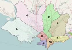
Montevideo

Municipios of Montevideo.png
# Municipality Population Area Major [3] Foundation
1 Municipality A 207,911144.2 km2Jorge Meroni (FA)15 March 2010
2 Municipality B 147,57711.8 km2Silvana Pissano (FA)15 March 2010
3 Municipality C 148,95217.6 km2Jorge Cabrera (FA)15 March 2010
4 Municipality CH 159,52812.1 km2Matilde Antía (PN)15 March 2010
5 Municipality D 181,15386.5 km2Gabriel Velazco (FA)15 March 2010
6 Municipality E 153,39527.5 km2Mercedes Ruiz (PN)15 March 2010
7 Municipality F 168,93785.0 km2Juan López (PN)15 March 2010
8 Municipality G 151,302142.7 km2Leticia de Torres (FA)15 March 2010

Paysandú

PaysanduMunicipiosTodos.svg
# Municipality Population Area Major Foundation
1 Chapicuy 1,3821,043.6 km2Milton Laurencena (PN)21 March 2013
2 Guichón 6,8601,670.1 km2Martín Álvarez (PN)15 March 2010
3 Lorenzo Geyres 1,704938.7 km2Graciela Barrutte (PN)21 March 2013
4 Piedras Coloradas 1,9561,192.7 km2Jhonn Cáceres (PN)21 March 2013
5 Porvenir 4,178954.5 km2Ramiro Ayende (PN)15 March 2010
6 Quebracho 3,6711,088.4 km2Silbia Visoso (PN)15 March 2010
7 Tambores 1,4752,388.0 km2Ricardo Soares (PN)21 March 2013

Río Negro

MunicipiosRioNEgro.svg
# Municipality Population Area Major Foundation
1 Nuevo Berlín 2,604498.7 km2Hernán Godoy (PN)15 March 2010
2 San Javier 2,830817.8 km2Washington Laco (PN)22 March 2013
3 Young 17,5501,039.8 km2Inés Long (PN)15 March 2010

Rivera

RiveraMunicipiosColores2017.svg
# Municipality Population Area Major Foundation
1 Minas de Corrales 3,985381.7 km2José González (PC)15 March 2010
2 Tranqueras 8,190976.6 km2Luciano Viera (PC)15 March 2010
3 Vichadero 4,048510.5 km2Luis Alberto Coutinho (PN)15 March 2010

Rocha

Municipios Rocha.svg
# Municipality Population Area Major Foundation
1 Castillos 9,6512,152.6 km2Juan Manuel Olivera (PN)15 March 2010
2 Chuy 9,75892.8 km2Eduardo Calabuig (PN)15 March 2010
3 La Paloma 5,516247.7 km2Sergio Muniz (FA)15 March 2010
4 Lascano 7,922745.5 km2Víctor Larrosa (PN)15 March 2010

Salto

Municipios de Salto.svg
# Municipality Population Area Major [3] Foundation
1 Belén 2,269164.7 km2Luis Zuliani (FA)15 March 2010
2 Colonia Lavalleja 2,4781,472.6 km2Antonio Tejeira (PN)15 March 2010
3 Mataojo 1,0282,241.5 km2Rosita Moreno (FA)15 March 2010
4 San Antonio 3,865430.8 km2Sandra Toncobitz (PC)15 March 2010
5 Rincón de Valentín 1,203872.8 km2Santiago Dalmao (FA)15 March 2010
6 Villa Constitución 3,8961,537.8 km2Carlos Souto (FA)15 March 2010

San José

SANJOSEmunicipioscolores.svg
# Municipality Population Area Major [3] Foundation
1 Ciudad del Plata 32,154125.8 km2Marianita Fonseca (PN)15 March 2010
2 Ecilda Paullier 5,025694.7 km2Leonardo Giménez (PN)22 March 2013
3 Libertad 14,326441.9 km2Matías Santos (PN)15 March 2010
4 Rodríguez 4,8491,167.3 km2Norberto Zunino (PN)22 March 2013

Soriano

SorianoMunicipios+colores+numeracion.svg
# Municipality Population Area Major [3] Foundation
1 Cardona 5,029356.1 km2Ruben Valentín (PN)15 March 2010
2 Dolores 19,577413.7 km2Juan Oronoz (PN)15 March 2010
3 José Enrique Rodó 3,077396.3 km2Washington Loitey (PN)27 March 2015
4 Palmitas 2,304178.7 km2Juan Vincon (PN)27 March 2015

Tacuarembó

# Municipality Population Area Major [3] Foundation
1 Ansina 3,289792.2 km2Ana Isabel Camejo (PN)27 March 2015
2 Paso de los Toros 13,232560.3 km2Luis Irigoin (PN)15 March 2010
3 San Gregorio de Polanco 3,722444.7 km2Asdrúbal Rodríguez (PN)15 March 2010

Treinta y Tres

Treintaytres+contorno+municipiocolores+numerados.svg
# Municipality Population Area Major [3] Foundation
1 Cerro Chato 1,407 km2Elías Javier Fuentes (PN)22 December 2017
2 Enrique Martínez 1,246 km2Nidia Vera (PN)22 December 2017
3 Rincón 1,767 km2Eduardo Gonzales (PN)22 December 2017
4 Santa Clara de Olimar 2,485482.4 km2Pablo Echevarría (PN)15 March 2010
5 Vergara 4,064622.5 km2José González (PN)15 March 2010
6 Villa Sara 1,724534 km2Analía Larrañaga (PN)22 December 2017

Related Research Articles

<span class="mw-page-title-main">Departments of Uruguay</span> Administrative territorial entity of Uruguay

Uruguay consists of 19 departments (departamentos). Each department has a legislature called a Departmental Board. The Intendente is the department's chief executive.

<span class="mw-page-title-main">Maldonado Department</span> Department of Uruguay

The Maldonado Department, with an area of 4,793 km2 (1,851 sq mi) and 164,300 inhabitants (2011), is located to the southeast of Uruguay. Its capital is Maldonado.

The Departamento de Canelones is one of the 19 Uruguayan departments. With an area of 4,536 km2 (1,751 sq mi) and 518,154 inhabitants, it is located in the south of Uruguay. Its capital is Canelones. Ciudad de la Costa is the largest city by total population and Las Piedras is the largest city with an official census.

<span class="mw-page-title-main">Montevideo Department</span> Department of Uruguay

Montevideo is a department (departamento) of Uruguay. It is by far the smallest department in area, but also by far the most populated. Its capital is the city of Montevideo, which is also the national capital. While most of the department is covered by the capital city, there are still smaller towns within its limits.

<span class="mw-page-title-main">Outline of Uruguay</span> Overview of and topical guide to Uruguay

The following outline is provided as an overview of and topical guide to Uruguay:

<span class="mw-page-title-main">Municipality of Sarandí del Yí</span> Municipality in Durazno, Uruguay

The municipality of Sarandí del Yí is one of the municipalities of Durazno Department, Uruguay. Its seat is the city of Sarandí del Yí.

<span class="mw-page-title-main">Municipality of Tupambaé</span> Municipality in Cerro Largo, Uruguay

The municipality of Tupambaé is one of the nine municipalities of Cerro Largo Department, Uruguay. Its seat is the city of Tupambaé.

<span class="mw-page-title-main">Municipality of Baltasar Brum</span> Municipality in Artigas, Uruguay

The municipality of Baltasar Brum is one of the three municipalities of Artigas Department. Its seat is the city of Baltasar Brum.

<span class="mw-page-title-main">Municipality of Maldonado</span> Municipality in Maldonado, Uruguay

The Municipality of Maldonado is one of the eight municipalities of Maldonado Department, Uruguay. It was created by Law N° 18653 of 15 March 2010.

<span class="mw-page-title-main">Municipality of Tomás Gomensoro</span> Municipality in Artigas, Uruguay

The municipality of Tomás Gomensoro is one of the three municipalities of Artigas Department. Its seat is the city of Tomás Gomensoro.

<span class="mw-page-title-main">Municipality of Quebracho, Paysandú</span> Municipality in Paysandú, Uruguay

The municipality of Quebracho is one of the municipalities of Paysandú Department. Its seat is the city of Quebracho.

<span class="mw-page-title-main">Municipality of Ombúes de Lavalle</span> Municipality in Colonia, Uruguay

The municipality of Ombúes de Lavalle is one of the municipalities in the Colonia Department, Uruguay. Its seat is the city of Ombúes de Lavalle.

<span class="mw-page-title-main">Municipality of Bella Unión</span> Artigas Department municipality, Uruguay

The municipality of Bella Unión is one of the municipalities of Artigas Department, Uruguay, established on 13 September 2009. Its seat is the city of Bella Unión. It replaced the Autonomous and Elective Local Board of Bella Union created in 1994.

<span class="mw-page-title-main">Municipality of Aguas Corrientes</span> Canelones Department municipality, Uruguay

The municipality of Aguas Corrientes is one of the municipalities of Canelones Department, Uruguay, established on 15 March 2010. Its seat is the city of Aguas Corrientes.

<span class="mw-page-title-main">Municipality of Tres Islas</span> Cerro Largo Department municipality, Uruguay

The municipality of Tres Islas is one of the municipalities of Cerro Largo Department, Uruguay, established on 30 October 2018. Its seat is the town of Tres Islas.

<span class="mw-page-title-main">Municipality of Río Branco</span> Cerro Largo Department municipality, Uruguay

The municipality of Río Branco is one of the municipalities of Cerro Largo Department, Uruguay, established on 13 September 2009. Its seat is the town of Río Branco. It replaced the Autonomous and Elective Local Board of Río Branco established in 1960.

<span class="mw-page-title-main">Municipality of Ramón Trigo</span> Cerro Largo Department municipality, Uruguay

The municipality of Ramón Trigo is one of the municipalities of Cerro Largo Department, Uruguay, established on 3 April 2013. Its seat is the town of Ramón Trigo.

<span class="mw-page-title-main">Municipality of Quebracho, Cerro Largo</span> Cerro Largo Department municipality, Uruguay

The municipality of Quebracho is one of the municipalities of Cerro Largo Department, Uruguay, established on 30 October 2018. Its seat is the settlement of Quebracho.

<span class="mw-page-title-main">Municipality of La Floresta</span> Canelones Department municipality, Uruguay

The municipality of La Floresta is one of the municipalities of Canelones Department, Uruguay, established on 15 March 2010. Its seat is the city of La Floresta.

<span class="mw-page-title-main">Municipality of San Gregorio de Polanco</span> Tacuarembó Department municipality, Uruguay

The municipality of San Gregorio de Polanco is one of the municipalities of Tacuarembó Department, Uruguay, established on 15 March 2010.

References

  1. "Ley N° 18567". www.impo.com.uy. Retrieved 2022-08-28.
  2. 1 2 "Ley N° 19272". www.impo.com.uy. Retrieved 2022-08-28.
  3. 1 2 3 4 5 6 7 8 9 10 11 12 13 14 15 "Alcaldes y Alcaldesas asumieron en los 125 Municipios de Uruguay" (in Spanish). Office of Planning and Budget. 30 November 2020. Retrieved 10 December 2020.
  4. 1 2 3 "Ley N° 18653" (in Spanish). IMPO. Retrieved 27 July 2022.
  5. "DECRETO Nº 11/13" (PDF) (in Spanish). Junta Departamental de Cerro Largo. Retrieved 2023-03-28.
  6. "DECRETO N.º 29/2018" (PDF) (in Spanish). Junta Departamental de Cerro Largo. Retrieved 2023-03-28.
  7. "DECRETO JDF Nº 06/2013" (in Spanish). Departmental Board of Florida. Retrieved 2023-05-08.