Geology of Uruguay

Last updated
Cerro Batovi is an erosional remnant made up of flood basalt overlying sedimentary rocks. Cerro Batovi.JPG
Cerro Batoví is an erosional remnant made up of flood basalt overlying sedimentary rocks.
Approximate location of Mesoproterozoic (older than 1.3 Ga) cratons in South America and Africa Cratons West Gondwana.svg
Approximate location of Mesoproterozoic (older than 1.3 Ga) cratons in South America and Africa

The geology of Uruguay combines areas of Precambrian-aged shield units with a region of volcanic rock erupted during the Cretaceous and copious sedimentary facies the oldest of which date from the Devonian. Big events that have shaped the geology of Uruguay include the Transamazonian orogeny (2000 million years ago (mya)), the breakup of Rodinia (700–500 mya) and the opening of the South Atlantic (~145 mya).

Contents

Shield region

Shear zones and terranes in Uruguay after Gaucher et al., 2008. Sarandi del Yi Shear Zone is marked as "SYSZ". To the east Sierra Ballena Shear Zone is marked as "SBSZ". Uruguay fisico-SZ.png
Shear zones and terranes in Uruguay after Gaucher et al., 2008. Sarandí del Yí Shear Zone is marked as "SYSZ". To the east Sierra Ballena Shear Zone is marked as "SBSZ".

The Precambrian shield in Uruguay includes part of Río de la Plata craton, an extensive area of stable crystalline basement rock underlying Uruguay and large areas of eastern Argentina and southern Brazil. The shield in Uruguay goes under the name of Rio Grande do Sul—Uruguay Shield and includes parts of Southern Brazil. [2] Though the Río de la Plata Craton underlies practically all of Uruguay, it only shows up in the south and east of the country since in other parts of the country, it is covered by younger volcanic rocks or sediments. The shield was formed during two orogenic events; one 2000 million years ago (mya) for the western part and another 700–500 mya for the eastern part. [3] The later orogenic event is the result of the accretion of blocks and terranes in the aftermath of the breakup of Rodinia when São Francisco and Río de la Plata cratons formed one plate in the west of the Adamastor Ocean. [4] The eastern part of the Uruguayan shield region is crossed by two major shear zones both running roughly in north-south direction the dextral Sarandí del Yí-Piriápolis Shear Zone and the sinistral Sierra Ballena Shear Zone. [3] West of Sarandí del Yí Shear Zone the Río de la Plata Craton is intruded by the Late Paleoproterozoic Florida dyke swarm. [5]

The area between Sarandí del Yí and Sierra Ballena shear zones –that is the Nico Pérez Terrane– is made of metamorphic and granitoid rocks which are the oldest rocks in Uruguay. [6] It has not been established to which degree this terrane belongs to or has affinity with the Río de la Plata Craton. [6] The rocks of Nico Pérez Terrane formed originally in the Archean eon and Paleoproterozoic era and much were later affected by the Brasiliano orogeny in Neoproterozoic era. [6]

Sedimentary formations

After the assembly of the final shield configuration the territory of Uruguay have been covered by several sedimentary formations ranging from Devonian sandstones to Quaternary loess. All of the sedimentary formations covers only patches of the country since deposition have not been uniform and erosion have cleaned surfaces, creeks and shores.

Sedimentary rocks of Lower Devonian age are found in the central part of Uruguay being exposed as a narrow east-west to northeast oriented band. The upper and better known part of this sequence is made up of sandstone. The lower sandstones of this sequence have characteristics similar to the Furnas Formation of São Paulo in Brazil. [7] During the Late Paleozoic the territory of Uruguay was affected by the Karoo Glaciation and was subsequently covered by ice lobes of the great ice sheet that covered large parts of Gondwana. Glacial striae on shales and varve-like sediments found in Uruguay have been associated with this glaciation. [8]

During the early rifting stages of the South Atlantic the area of southern Paraná Basin suffered a gentle uplifting that deviated sediments into the Tacuarembó region of Uruguay. These changes led to the formation of the Itacuanbú and Tacuarembó formations during the Mid Jurassic to Early Cretaceous. Parts of the Tacuarembó formation came to be preserved thanks to a unit of the Paraná traps, the Arapey basalts, that erupted 132 mya and covered the sediments. [9]

Paraná traps

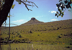
In the north of Uruguay, volcanic materials from the Paraná continental flood basalt province form a major lithological unit extending beyond Uruguay's borders into Argentina and Brazil, with parts of it now lying in Namibia on the other side of the Atlantic due to plate tectonics. This volcanic material erupted in the Cretaceous period during the opening of the South Atlantic and has been linked to the Tristan da Cunha plume. [10] The bulk of this volcanic material is basalt but there are rhyolites as well. Associated with this volcanism are also syenite and other granitoid intrusions exposed as outcrops in small areas of Southeastern Uruguay. [11] Although volcanic rocks of the Paraná volcanism underlies more than half of Uruguay, they have in many areas been covered by younger sediments so that the lavas only crop out as a geological province in the Uruguayan northwest. [12]

Related Research Articles

<span class="mw-page-title-main">Geology of Australia</span> Overview of the geology of Australia

The geology of Australia includes virtually all known rock types, spanning a geological time period of over 3.8 billion years, including some of the oldest rocks on earth. Australia is a continent situated on the Indo-Australian Plate.

<span class="mw-page-title-main">Río de la Plata Craton</span> Medium-sized continental block in Uruguay, eastern Argentina and southern Brazil

The Rio de la Plata Craton (RPC) is a medium-sized continental block found in Uruguay, eastern Argentina and southern Brazil. During its complex and protracted history it interacted with a series other blocks and is therefore considered important for the understanding of the amalgamation of West Gondwana. Two orogenic cycles have been identified in the RPC: a 2000 Ma-old western domain representing the old craton and a 700–500 Ma-old eastern domain assigned to the Brasiliano Cycle. It is one of the five cratons of the South American continent. The other four cratons are: Amazonia, São Francisco, Río Apa and Arequipa–Antofalla.

<span class="mw-page-title-main">Laurentia</span> A large continental craton that forms the ancient geological core of the North American continent

Laurentia or the North American Craton is a large continental craton that forms the ancient geological core of North America. Many times in its past, Laurentia has been a separate continent, as it is now in the form of North America, although originally it also included the cratonic areas of Greenland and also the northwestern part of Scotland, known as the Hebridean Terrane. During other times in its past, Laurentia has been part of larger continents and supercontinents and itself consists of many smaller terranes assembled on a network of Early Proterozoic orogenic belts. Small microcontinents and oceanic islands collided with and sutured onto the ever-growing Laurentia, and together formed the stable Precambrian craton seen today.

The West African Craton (WAC) is one of the five cratons of the Precambrian basement rock of Africa that make up the African Plate, the others being the Kalahari craton, Congo craton, Saharan Metacraton and Tanzania Craton. Cratons themselves are tectonically inactive, but can occur near active margins, with the WAC extending across 14 countries in Western Africa, coming together in the late Precambrian and early Palaeozoic eras to form the African continent. It consists of two Archean centers juxtaposed against multiple Paleoproterozoic domains made of greenstone belts, sedimentary basins, regional granitoid-tonalite-trondhjemite-granodiorite (TTG) plutons, and large shear zones. The craton is overlain by Neoproterozoic and younger sedimentary basins. The boundaries of the WAC are predominantly defined by a combination of geophysics and surface geology, with additional constraints by the geochemistry of the region. At one time, volcanic action around the rim of the craton may have contributed to a major global warming event.

This is a list of articles related to plate tectonics and tectonic plates.

<span class="mw-page-title-main">Geology of Russia</span> Overview of the geology of Russia

<span class="mw-page-title-main">Tuareg Shield</span> Geological formation between the West African craton and the Saharan Metacraton in West Africa

The Tuareg Shield is a geological formation lying between the West African craton and the Saharan Metacraton in West Africa. Named after the Tuareg people, it has complex a geology, reflecting the collision between these cratons and later events. The landmass covers parts of Algeria, Niger and Mali.

<span class="mw-page-title-main">Geology of Paraguay</span>

The country of Paraguay lies geologically at the borderzone between several cratons. Due to thick Cenozoic sediment cover and regolith development few outcrops are available in Paraguay. East of Paraguay River Precambrian and Early Paleozoic crystalline basement crop out mainly in the heights of Caapucú and Apa. The geological processes that have shaped Paraguay's bedrock and sedimentary basins are diverse including rifting, marine sedimentation, metamorphism, eruption of flood basalts and alkaline potassic volcanism.

<span class="mw-page-title-main">East Antarctic Shield</span> Cratonic rock body which makes up most of the continent Antarctica

The East Antarctic Shield or Craton is a cratonic rock body that covers 10.2 million square kilometers or roughly 73% of the continent of Antarctica. The shield is almost entirely buried by the East Antarctic Ice Sheet that has an average thickness of 2200 meters but reaches up to 4700 meters in some locations. East Antarctica is separated from West Antarctica by the 100–300 kilometer wide Transantarctic Mountains, which span nearly 3,500 kilometers from the Weddell Sea to the Ross Sea. The East Antarctic Shield is then divided into an extensive central craton that occupies most of the continental interior and various other marginal cratons that are exposed along the coast.

<span class="mw-page-title-main">Geology of Iran</span>

The main points that are discussed in the geology of Iran include the study of the geological and structural units or zones; stratigraphy; magmatism and igneous rocks; ophiolite series and ultramafic rocks; and orogenic events in Iran.

<span class="mw-page-title-main">Sierra Ballena Shear Zone</span>

Sierra Ballena Shear Zone or SBSZ is a sinistral strike-slip shear zone running across the Uruguayan Shield in eastern Uruguay and the Brazilian state of Rio Grande do Sul. The system was last active in the Precambrian.

<span class="mw-page-title-main">Uruguayan dyke swarms</span>

The Uruguayan dyke swarms consist of three groups of dykes of Precambrian age that intrude Río de la Plata Craton and Brasiliano Cycle continental crust in Uruguay. The dykes – including the Florida dyke swarm, the Nico Perez dyke swarm, and the Treinta y Tres dyke swarm – are of mafic to intermediate composition and each group lies in a separate tectono-stratigraphic terrane. The rocks of the Florida dyke swarm have been quarried since the 1960s and are used in the construction industry as black dimension stone of very high quality, being marketed as "black granite".

<span class="mw-page-title-main">Tectonic evolution of the Aravalli Mountains</span> Overview article

The Aravalli Mountain Range is a northeast-southwest trending orogenic belt in the northwest part of India and is part of the Indian Shield that was formed from a series of cratonic collisions. The Aravalli Mountains consist of the Aravalli and Delhi fold belts, and are collectively known as the Aravalli-Delhi orogenic belt. The whole mountain range is about 700 km long. Unlike the much younger Himalayan section nearby, the Aravalli Mountains are believed much older and can be traced back to the Proterozoic Eon. They are arguably the oldest geological feature on Earth. The collision between the Bundelkhand craton and the Marwar craton is believed to be the primary mechanism for the development of the mountain range.

<span class="mw-page-title-main">Geology of Ivory Coast</span>

The geology of Ivory Coast is almost entirely extremely ancient metamorphic and igneous crystalline basement rock between 2.1 and more than 3.5 billion years old, comprising part of the stable continental crust of the West African Craton. Near the surface, these ancient rocks have weathered into sediments and soils 20 to 45 meters thick on average, which holds much of Ivory Coast's groundwater. More recent sedimentary rocks are found along the coast. The country has extensive mineral resources such as gold, diamonds, nickel and bauxite as well as offshore oil and gas.

The geology of Mozambique is primarily extremely old Precambrian metamorphic and igneous crystalline basement rock, formed in the Archean and Proterozoic, in some cases more than two billion years ago. Mozambique contains greenstone belts and spans the Zimbabwe Craton, a section of ancient stable crust. The region was impacted by major tectonic events, such as the mountain building Irumide orogeny, Pan-African orogeny and the Snowball Earth glaciation. Large basins that formed in the last half-billion years have filled with extensive continental and marine sedimentary rocks, including rocks of the extensive Karoo Supergroup which exist across Southern Africa. In some cases these units are capped by volcanic rocks. As a result of its complex and ancient geology, Mozambique has deposits of iron, coal, gold, mineral sands, bauxite, copper and other natural resources.

<span class="mw-page-title-main">Geology of Tanzania</span>

The geology of Tanzania began to form in the Precambrian, in the Archean and Proterozoic eons, in some cases more than 2.5 billion years ago. Igneous and metamorphic crystalline basement rock forms the Archean Tanzania Craton, which is surrounded by the Proterozoic Ubendian belt, Mozambique Belt and Karagwe-Ankole Belt. The region experienced downwarping of the crust during the Paleozoic and Mesozoic, as the massive Karoo Supergroup deposited. Within the past 100 million years, Tanzania has experienced marine sedimentary rock deposition along the coast and rift formation inland, which has produced large rift lakes. Tanzania has extensive, but poorly explored and exploited natural resources, including coal, gold, diamonds, graphite and clays.

The geology of Eswatini formed beginning 3.6 billion years ago, in the Archean Eon of the Precambrian. Eswatini is the only country entirely underlain by the Kaapvaal Craton, one of the oldest pieces of stable continental crust and the only craton regarded as "pristine" by geologists, other than the Yilgarn Craton in Australia. As such, the country has very ancient granite, gneiss and in some cases sedimentary rocks from the Archean into the Proterozoic, overlain by sedimentary rocks and igneous rocks formed during the last 539 million years of the Phanerozoic as part of the Karoo Supergroup. Intensive weathering has created thick zones of saprolite and heavily weathered soils.

The geology of Brazil includes very ancient craton basement rock from the Precambrian overlain by sedimentary rocks and intruded by igneous activity, as well as impacted by the rifting of the Atlantic Ocean.

<span class="mw-page-title-main">Western Block of the North China Craton</span>

The Western Block of the North China Craton is an ancient micro-continental block mainly composed of Neoarchean and Paleoproterozoic rock basement, with some parts overlain by Cambrian to Cenozoic volcanic and sedimentary rocks. It is one of two sub-blocks within the North China Craton, located in east-central China. The boundaries of the Western Block are slightly different among distinct models, but the shapes and areas are similar. There is a broad consensus that the Western Block covers a large part of the east-central China.

<span class="mw-page-title-main">Mazatzal orogeny</span> Mountain-building event in North America

The Mazatzal orogeny was an orogenic event in what is now the Southwestern United States from 1650 to 1600 Mya in the Statherian Period of the Paleoproterozoic. Preserved in the rocks of New Mexico and Arizona, it is interpreted as the collision of the 1700-1600 Mya age Mazatzal island arc terrane with the proto-North American continent. This was the second in a series of orogenies within a long-lived convergent boundary along southern Laurentia that ended with the ca. 1200–1000 Mya Grenville orogeny during the final assembly of the supercontinent Rodinia, which ended an 800-million-year episode of convergent boundary tectonism.

References

  1. Gaucher, C.; Finney, S. C.; Poiré, D. G.; Valencia, V. A.; Grove, M.; Blanco, G.; Pamoukaghlián, K.; Peral, L. G. (2008). "Detrital zircon ages of Neoproterozoic sedimentary successions in Uruguay and Argentina: insights into the geological evolution of the Río de la Plata Craton". Precambrian Research . 167 (1): 150–170. Bibcode:2008PreR..167..150G. doi:10.1016/j.precamres.2008.07.006. hdl: 11336/74329 .
  2. Butler, Louis W. 1970. Shallow structure of the Continental Margin, Southern Brazil and Uruguay. GSA Bulletin.
  3. 1 2 Bossi, Jorge; Gaucher, Claudio (2004), "The Cuchilla Dionisio Terrane, Uruguay: An Allochthonous Block Accreted in the Cambrian to SW-Gondwana", Gondwana Research, 7 (3): 661–674, doi:10.1016/S1342-937X(05)71054-6
  4. Benjamin Bley de Brito Neves, Mário da Costa Campos Neto and Reinhardt Adolfo Fuck. 1999. From Rodinia to Western Gondwana: An approach to the Brasiliano-Pan African Cycle and orogenic collage
  5. Mazzucchelli, Maurizio; Rivalenti, Giorgio; Piccirillo, Enzo Michele; Vitorio Girardi, Vicente Antonio; Civetta, Lucia; Petrini, Riccardo (1995). "Petrology of the Proterozoic mafic dyke swarms of Uruguay and constraints on their mantle source composition". Precambrian Research . 74 (3): 177–194. doi:10.1016/0301-9268(95)00014-V.
  6. 1 2 3 Sánchez Bettucci, Leda; Cordani, Umberto; Loureiro, Judith; Peel, Elena; Fort, Santiago; Sato, Kei (2021). "The Nico Pérez terrane (Uruguay) and its archean and paleoproterozoic inheritance". Andean Geology . 48 (3): 442–471. doi: 10.5027/andgeoV48n3-3345 . Retrieved November 28, 2021.
  7. Harrington, Horacio J. Uruguay - Handbook of South American Geology. 1956.
  8. Lawrence A. Frakes and John C. Crowell. 1969. Late Paleozoic Glaciation: I, South America, GSA Bulletin
  9. Perea, Daniel; Soto, Matías; Veroslavsky, Gerardo; Martínez, Sergio; Ubilla, Martín (2009), "A Late Jurassic fossil assemblage in Gondwana: Biostratigraphy and correlations of the Tacuarembó Formation, Parana Basin, Uruguay", Journal of South American Earth Sciences, 28 (2): 168, doi:10.1016/j.jsames.2009.03.009
  10. Stewart, Kathy; Turner, Simon; Kelley, Simon; Hawkesworth, Chris; Kirstein, Linda; Mantovani, Marta (1996), "3-D,40Ar-39Ar geochronology in the Paraná continental flood basalt province", Earth and Planetary Science Letters, 143: 95, doi:10.1016/0012-821X(96)00132-X
  11. Lustrino, M.; Gomes, C.B; Melluso, L.; Morbidelli, L.; Muzio, R.; Ruberti, E. and Tassinari, C.C.G. Early Cretaceous Magmatic Activity in Southeast Uruguay: Trace Elements and Sr-Nd Isotopic Constraints Archived 2011-07-20 at the Wayback Machine
  12. David S. Thiede and Paulo M. Vasconcelos. 2010. Paraná flood basalts: Rapid extrusion hypothesis confirmed by new 40Ar/39Ar results. Geology vol 38.