Geology of Suriname

Last updated
Standing in the Marowijne River Guyane 0002.jpg
Standing in the Marowijne River

The geology of Suriname is predominantly formed by the Guyana Shield, which spans 90% of its land area. Coastal plains account for the remaining ten percent. Most rocks in Suriname date to the Precambrian. These crystalline basement rocks consists of granitoid and acid volcanic rocks with enclaves of predominantly low-grade metamorphic, geosynclinal rocks in the Marowijne area and of probably considerably older rocks in the Falawatra group of the Bakhuisgebirge and the Coronie area. There are also small, scattered bodies of gabbro and ultramafitite. These are about the same age as the granite and volcanics. It has been found that the construction of the basement was largely created during the final phase of the Trans-Amazonian Orogeny Cycle, about 1.9 billion years ago. This cycle has had a significant influence on the geology of Suriname, characterized by sedimentation, metamorphosis, corrugation and magmatism. [1]

Contents

Young sediments cover the northern 20% of the country. They exist from south to north and from old to young from the Coesewine, Coropina and Demarara formations. The older Onverdacht formation is only accessible at Moengo. In the coastal area, the three first mentioned formations are accessible in the savannah belt, the old coastal plain and the marshy young coastal plain. They show a slight, northward slope. The late Pleistocene Coropina Formation and the Holocene Demerara Formation consist of clay mud banks set up in a lagoon region with zigzagging complexes (beach walls) formed of sand and shells. The Coesewijne Formation in the savannah belt consists of coarse, unsorted sands with kaolinite clays. These are probably deposited by braided streams and possibly partly in alluvial deltas. The Coesewijne formation is of Pliocene age. The Onverdacht Formation consists of unsorted sands and kaolinite clays and is covered with bauxite on the surface at Moengo, with subordinate bauxites at Onverdacht. This formation forms old hills protected by the bauxite cover against erosion around which the younger formations have been deposited. [2]

Early geological surveys

The first known geological survey in Suriname dates back to 1720. Friederich Voltz carried out systematic geological research for the first time in 1853. This research was conducted along the lower reaches of the major rivers. In 1888, the first overview map of Suriname with geological data was published by Karl Martin. Until 1900 the interest was focused on gold. Until the 20th century, interest in the geology of the country usually had a more or less local and incidental character. In 1931 R. IJzerman collected all geological research from the period 1853 - 1930 in his dissertation, it gives a fairly complete picture of the geology of Suriname and is provided with a geological overview. [3]

Geological distribution

Coastal plain

The fertile coastal plain consists of marine clay deposits, weathering products from the Andean mountain range that reached the coast of Suriname via the Amazon River and the Guiana Current. [4] The coastline is mobile because land is washed away repeatedly under the influence of storms and currents. [5]

The knowledge of the geology of the Surinamese coastal plain has increased in the 20th century. In 1931 IJzerman gave a general description of the sediments that occur in the foreland. He distinguished two layers of groups: the fluvio-marine deposits, in which clays and sands occur and the older continental alluvium, for a large part consisting of coarse white, sometimes humus-bearing sands. The fluvio-marine deposits lie in a belt immediately along the coast and the continental alluvium comes to the surface in a belt behind it, wedging against the rocks of the Guiana Shield. The geologist Jan Zonneveld, who worked at the Centraal Bureau Luchtkartering in Paramaribo, around 1950, after studying the use of water level profiles, field research and the interpretation of aerial photographs, was of the opinion that on the surface not two, but three elements should be distinguished, namely from north to south:

Some authorities still distinguish a fourth element, namely "the domestic remaining highlands". [7]

Inland lowlands

The low terrains between the mountains show a "multi-convex" relief over large expanses, which consists of countless low bulging hills. The hills have a striking similarity in top height. The different top levels are arranged in a stepwise manner and can be followed along the river in an upstream direction. They are believed to be remnants of earlier flattening. This stepwise succession of plains must have been achieved because the interior has undergone a tectonic upheaval from time to time, which forced the rivers to cut downward, after which surface formation could occur again. A large part of the erosion material was deposited in the falling coastal area. The fragmentation of the stepped relief into a "multiconvex" hill landscape must have taken place during the last part of the Pleistocene. [8]

Mountain range

The mountainous region of Suriname forms a 'central core' from which foothills radiate in different directions. In the northern part of the country, the Brownsberg, the Hok A Hingeberg, the Nassau mountain range and the Lely mountain range are striking elements. Outside the actual mountain ranges, the lowlands, there are various isolated mountains. Some of these are: the Tebu, the Roosevelt peak and the Voltzberg. Some of these mountains have flat shapes, for example Table Mountain in the Tafelberg Nature Reserve. Table Mountain consists of a plate of Roraima sandstone. The Roraima Formation only occurs on Table Mountain and in the Emma Range. The Brownsberg, the Bakhuis, Hok A Hin-, Nassau and Lely Mountains are characterized by plateaus that consist of laterite and local bauxite crusts. [9]

Savanna in the interior

In Suriname, savanna areas occur both in the northern lowlands and in the more hilly areas of the interior. The savannas of Suriname probably owe their origin to the savanna climate that dominated 10,000 years ago. The current ecosystem of the savanna changes through human activities such as sand excavations. [10]

There are three areas that are characterized by the presence of savannas:

On sandstone, granite and laterite caps, there are smaller, more or less individually occurring savannahs here and there.

The savannas cover about one percent of the Surinamese landscape. Approximately one fifth of the known plant species of Suriname occur in these areas. Savannas can be classified on the basis of the vegetation. There are bush and grass savannas and savanna forest, the latter is distinguished by the higher and denser vegetation.

Natural resource geology

The Suriname Planatlas of 1988 mentions the following mineral resources:

Geological Mining Service

In Suriname, research into the soil and geology is mainly conducted by the Geological Mining Service. Geological research is often not easy because a large part of the country is difficult to reach and is covered with dense forests. This service is also responsible for stimulating mining in general. [12] In 2013, Surinamese institutions in collaboration with Brazil worked on a mapping project at the southern border of the country in the Sipaliwini district. [13] The project will lead to the implementation of new topographic, hydrographic, geological, geophysical and structural maps. The new maps will be composed with the most modern tools that Brazil has. The project is being carried out by the Suriname Environmental and Mining Foundation together with the Geological Mining Service (GMD), the Anton de Kom University of Suriname and the Geological Service of Brazil. [14]

Related Research Articles

<span class="mw-page-title-main">Bauxite</span> Sedimentary rock rich in aluminium

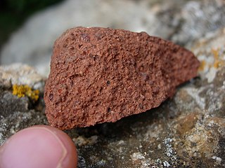
Bauxite is a sedimentary rock with a relatively high aluminium content. It is the world's main source of aluminium and gallium. Bauxite consists mostly of the aluminium minerals gibbsite (Al(OH)3), boehmite (γ-AlO(OH)) and diaspore (α-AlO(OH)), mixed with the two iron oxides goethite (FeO(OH)) and haematite (Fe2O3), the aluminium clay mineral kaolinite (Al2Si2O5(OH)4) and small amounts of anatase (TiO2) and ilmenite (FeTiO3 or FeO.TiO2). Bauxite appears dull in luster and is reddish-brown, white, or tan.

<span class="mw-page-title-main">Marowijne District</span> District of Suriname

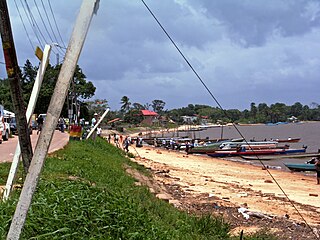
Marowijne is a district of Suriname, located on the north-east coast. Marowijne's capital city is Albina, with other towns including Moengo and Wanhatti. The district borders the Atlantic Ocean to the north, French Guiana to the east, the Surinamese district of Sipaliwini to the south, and the Surinamese districts of Commewijne and Para to the west.

<span class="mw-page-title-main">Sipaliwini District</span> District of Suriname

Sipaliwini is the largest district of Suriname, located in the south. Sipaliwini is the only district that does not have a regional capital, as it is directly administered by the national government in Paramaribo.

<span class="mw-page-title-main">Maroni (river)</span> River in South America, forming the border between Suriname and French Guiana

The Maroni or Marowijne is a river in South America that forms the border between French Guiana and Suriname.

<span class="mw-page-title-main">Tapanahony River</span> River in Sipaliwini District, Suriname

The Tapanahony River is a major river in the south eastern part of Suriname, South America. The river originates in the Southern part of the Eilerts de Haan Mountains, near the border with Brazil. It joins the Marowijne River at a place called Stoelmanseiland. Upstream, there are many villages inhabited by Indian Tiriyó people, while further downstream villages are inhabited by the Amerindian Wayana and Maroon Ndyuka people.

<span class="mw-page-title-main">Coppename River</span> River in Coronie & Saramacca District, Suriname

The Coppename is a river in Suriname in the district of Sipaliwini, forming part of the boundary between the districts of Coronie and Saramacca.

<span class="mw-page-title-main">Commewijne River</span> River in north Suriname

Commewijne River is a river in northern Suriname.

The Eilerts de Haan Mountains are a mountain range in Sipaliwini District, Suriname. It is a southern part of Wilhelmina Mountains and is maximum 986 m high. The mountain range is part of the Central Suriname Nature Reserve.

<span class="mw-page-title-main">Tumuk Humak Mountains</span>

The Tumuk Humak Mountains are a mountain range in South America, stretching about 120 kilometers (75 mi) east–west in the border area between Brazil in the south and Suriname and French Guiana in the north. In the language of the Apalam and Wayana peoples, Tumucumaque means "the mountain rock symbolizing the struggle between the shaman and the spirits". The range is very remote and almost inaccessible.

<span class="mw-page-title-main">Angadipuram Laterite</span> City in Kerala, India

Angadipuram Laterite is a notified National Geo-heritage Monument in Angadipuram town in Malappuram district in the southern Indian state of Kerala, India. The special significance of Angadipuram to laterites is that it was here that Dr. Francis Buchanan-Hamilton, a professional surgeon, gave the first account of this rock type, in his report of 1807, as "indurated clay", ideally suited for building construction. This formation falls outside the general classification of rocks namely, the igneous, metamorphic, or sedimentary rocks but is an exclusively "sedimentary residual product". It has generally a pitted and porous appearance. The name laterite was first coined in India, by Buchanan and its etymology is traced to the Latin word "letritis" that means bricks. This exceptional formation is found above parent rock types of various composition namely, charnockite, leptynite, anorthosite and gabbro in Kerala. It is found over basalt in the states of Goa, Maharashtra and in some regions of Karnataka. In Gujarat in western India, impressive formations of laterite are found over granite, shale and sandstone..

<span class="mw-page-title-main">Laterite</span> Product of rock weathering in wet tropical climate rich in iron and aluminium

Laterite is both a soil and a rock type rich in iron and aluminium and is commonly considered to have formed in hot and wet tropical areas. Nearly all laterites are of rusty-red coloration, because of high iron oxide content. They develop by intensive and prolonged weathering of the underlying parent rock, usually when there are conditions of high temperatures and heavy rainfall with alternate wet and dry periods. Tropical weathering (laterization) is a prolonged process of chemical weathering which produces a wide variety in the thickness, grade, chemistry and ore mineralogy of the resulting soils. The majority of the land area containing laterites is between the tropics of Cancer and Capricorn.

Operation Grasshopper was a project to look for natural resources in Suriname from the air. For this project, seven airstrips were constructed in the interior of Suriname from 1959 onward.

<span class="mw-page-title-main">Geology of Guinea</span>

Geologically, Guinea is covered by a crust of a very large Archean West African Craton with its northern and western regions having formations of younger Proterozoic rocks and its eastern region consists greenstone belts under the Birimian Supergroup which account for a major portion of West Africa's gold and iron ore reserves. Weathering of paleozoïcs schists has resulted in laterisiation leading to the formation of very large bauxite deposits.

Medische Zending Primary Health Care Suriname, commonly known as Medische Zending or MZ is a Surinamese charitable organization offering primary healthcare to remote villages in the interior of Suriname.

<span class="mw-page-title-main">Geology of Ivory Coast</span>

The geology of Ivory Coast is almost entirely extremely ancient metamorphic and igneous crystalline basement rock between 2.1 and more than 3.5 billion years old, comprising part of the stable continental crust of the West African Craton. Near the surface, these ancient rocks have weathered into sediments and soils 20 to 45 meters thick on average, which holds much of Ivory Coast's groundwater. More recent sedimentary rocks are found along the coast. The country has extensive mineral resources such as gold, diamonds, nickel and bauxite as well as offshore oil and gas.

<span class="mw-page-title-main">Geology of Sierra Leone</span>

The geology of Sierra Leone is primarily very ancient Precambrian Archean and Proterozoic crystalline igneous and metamorphic basement rock, in many cases more than 2.5 billion years old. Throughout Earth history, Sierra Leone was impacted by major tectonic and climatic events, such as the Leonean, Liberian and Pan-African orogeny mountain building events, the Neoproterozoic Snowball Earth and millions of years of weathering, which has produced thick layers of regolith across much of the country's surface.

<span class="mw-page-title-main">Pamacca</span> Resort in the Sipaliwini District of Suriname

Paramacca is a resort in Suriname, located in the Sipaliwini District. The population is estimated between 1,500 and 2,000 people. In 1983, the Sipaliwini District was created, and the eastern part became the resort of Tapanahony. The Paramacca resort is the northern part of Tapanahony, and mainly inhabited by the Paramaccan people, the border of the resorts is the island of Bofoo Tabiki in the Marowijne River.

The De Goeje Mountains is a mountain range in the Sipaliwini District of Suriname. It is named after Claudius de Goeje.

<span class="mw-page-title-main">Magneetrots</span>

Magneetrots is a mountain in the Sipaliwini District of Suriname. It measures 310 metres.

<span class="mw-page-title-main">Onverdacht</span> Village in Para District, Suriname

Onverdacht is a village in the resort of Zuid in the Para District of Suriname. Between 1941 and 2009, it was a bauxite mining town.

References

  1. Bruijning, C.F.A. en J. Voorhoeve (red.): Encyclopedie van Suriname. Amsterdam en Brussel 1977, blz. 218.
  2. Bruijning, C.F.A. en J. Voorhoeve (red.): Encyclopedie van Suriname. Amsterdam en Brussel 1977, blz. 219 e.v.
  3. Bruijning, C.F.A. en J. Voorhoeve (red.): Encyclopedie van Suriname. Amsterdam en Brussel 1977, blz. 227.
  4. Mol, Arthur, e.a. (red.) (2004): Suriname schoon genoeg? Hulpbronnen gebruik en milieubescherming in een klein Amazoneland, blz. 1, Uitgeverij Jan van Arkel
  5. Helman, Albert (1982): Avonturen aan de wilde kust. De geschiedenis van Suriname met zijn buurlanden, blz. 13, Uitgeverij Vaco
  6. Helman, Albert (1982): Avonturen aan de wilde kust. De geschiedenis van Suriname met zijn buurlanden, blz. 13, Uitgeverij Vaco
  7. "Zesde milieustatistieken publicatie 2014, blz. 143". Archived from the original on 2016-03-06. Retrieved 2018-08-20.
  8. Bruijning, C.F.A. en J. Voorhoeve (red.): Encyclopedie van Suriname, Amsterdam en Brussel 1977, blz. 231.
  9. Bruijning, C.F.A. en J. Voorhoeve (red.): Encyclopedie van Suriname, Amsterdam en Brussel 1977, blz. 230.
  10. Vakblad Bos en Natuur, no.5, 2013, De waarde van savanne ecosystemen, Serano Ramcharan, blz. 12 en 13 https://web.archive.org/web/20170217061914/http://www.tropenbos.org/publications/quarterly%20specialist%20journal%20.
  11. Bron: https://web.archive.org/web/20150203171605/http://www.feweb.vu.nl/gis/publications/docs/Lassche_Molendijk_2013_GeologieSuriname.pdf
  12. "Ministerie van Natuurlijke Hulpbronnen - over NH". www.gov.sr. Archived from the original on 2012-10-13.
  13. "Starnieuws - Suriname werkt aan nieuwe geologische kaart".
  14. "Semif - Milieuduurzaamheid".