Greenstone belts are zones of variably metamorphosed mafic to ultramafic volcanic sequences with associated sedimentary rocks that occur within Archaean and Proterozoic cratons between granite and gneiss bodies.

The geology of Australia includes virtually all known rock types, spanning a geological time period of over 3.8 billion years, including some of the oldest rocks on earth. Australia is a continent situated on the Indo-Australian Plate.
The Bauru Group is a geological group of the Bauru Sub-basin, Paraná Basin in Minas Gerais, São Paulo, General Salgado, Itapecuru-Mirim, Mato Grosso, Brazil whose strata date back to the Late Cretaceous. Dinosaur remains are among the fossils that have been recovered from the formation.
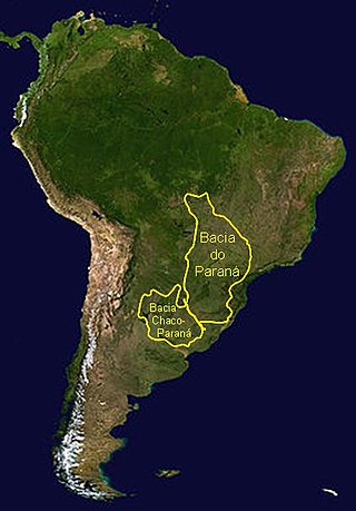
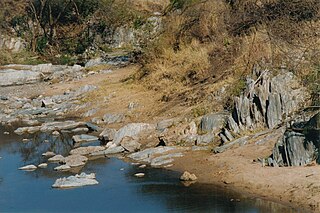
The Paraná Basin is a large cratonic sedimentary basin situated in the central-eastern part of South America. About 75% of its areal distribution occurs in Brazil, from Mato Grosso to Rio Grande do Sul states. The remainder area is distributed in eastern Paraguay, northeastern Argentina and northern Uruguay. The shape of the depression is roughly elliptical and covers an area of about 1,500,000 km2 (580,000 sq mi).

The geology of Russia, the world's largest country, which extends over much of northern Eurasia, consists of several stable cratons and sedimentary platforms bounded by orogenic (mountain) belts.

The geology of Uruguay combines areas of Precambrian-aged shield units with a region of volcanic rock erupted during the Cretaceous and copious sedimentary facies the oldest of which date from the Devonian. Big events that have shaped the geology of Uruguay include the Transamazonian orogeny, the breakup of Rodinia and the opening of the South Atlantic.
The Rio Bonito Formation is a geological formation of the Paraná and Pelotas Basins of Permian age. It is represented by a succession of cyclic sedimentary packages of sandstones, siltstones and shales which bear extensive deposits of coal that has been extracted since the 19th century. The Rio Bonito Formation was deposited in a coastal environment, formed by rivers, deltas, bays and estuaries with tidal plains, barrier islands and shallow marine platform, at a time when the Paraná Basin was a large gulf of the ancient supercontinent Gondwana. This gulf was open to the southwest, to the old ocean Panthalassa. The Rio Bonito Formation outcrops occur mainly in the eastern border of the Paraná Basin, in a narrow band in the states of São Paulo, Paraná, Santa Catarina, Rio Grande do Sul and Uruguay. The Rio Bonito Formation belongs to the second-order stratigraphic supersequence called Gondwana I.

The geology of Germany is heavily influenced by several phases of orogeny in the Paleozoic and the Cenozoic, by sedimentation in shelf seas and epicontinental seas and on plains in the Permian and Mesozoic as well as by the Quaternary glaciations.

The geology of Ghana is primarily very ancient crystalline basement rock, volcanic belts and sedimentary basins, affected by periods of igneous activity and two major orogeny mountain building events. Aside from modern sediments and some rocks formed within the past 541 million years of the Phanerozoic Eon, along the coast, many of the rocks in Ghana formed close to one billion years ago or older leading to five different types of gold deposit formation, which gave the region its former name Gold Coast.

The geology of the Democratic Republic of the Congo is extremely old, on the order of several billion years for many rocks. The country spans the Congo Craton: a stable section of ancient continental crust, deformed and influenced by several different mountain building orogeny events, sedimentation, volcanism and the geologically recent effects of the East Africa Rift System in the east. The country's complicated tectonic past have yielded large deposits of gold, diamonds, coltan and other valuable minerals.
The geology of Cameroon is almost universally Precambrian metamorphic and igneous basement rock, formed in the Archean as part of the Congo Craton and the Central African Mobile Zone and covered in laterite, recent sediments and soils. Some parts of the country have sequences of sedimentary rocks from the Paleozoic, Mesozoic and Cenozoic as well as volcanic rock produced by the 1600 kilometer Cameroon Volcanic Line, which includes the still-active Mount Cameroon. The country is notable for gold, diamonds and some onshore and offshore oil and gas.

The geology of Tanzania began to form in the Precambrian, in the Archean and Proterozoic eons, in some cases more than 2.5 billion years ago. Igneous and metamorphic crystalline basement rock forms the Archean Tanzania Craton, which is surrounded by the Proterozoic Ubendian belt, Mozambique Belt and Karagwe-Ankole Belt. The region experienced downwarping of the crust during the Paleozoic and Mesozoic, as the massive Karoo Supergroup deposited. Within the past 100 million years, Tanzania has experienced marine sedimentary rock deposition along the coast and rift formation inland, which has produced large rift lakes. Tanzania has extensive, but poorly explored and exploited natural resources, including coal, gold, diamonds, graphite and clays.

The geology of Senegal formed beginning more than two billion years ago. The Archean greenschist Birimian rocks common throughout West Africa are the oldest in the country, intruded by Proterozoic granites. Basins formed in the interior during the Paleozoic and filled with sedimentary rocks, including tillite from a glaciation. With the rifting apart of the supercontinent Pangaea in the Mesozoic, the large Senegal Basin filled with thick sequences of marine and terrestrial sediments. Sea levels declined in the Eocene forming large phosphate deposits. Senegal is blanketed in thick layers of terrestrial sediments formed in the Quaternary. The country has extensive natural resources, including gold, diamonds, and iron.
The geology of Libya formed on top of deep and poorly understood Precambrian igneous and metamorphic crystalline basement rock. Most of the country is intra-craton basins, filled with thick layers of sediment. The region experienced long-running subsidence and terrestrial sedimentation during the Paleozoic, followed by phases of volcanism and intense folding in some areas, and widespread flooding in the Mesozoic and Cenozoic due to a long marine transgression. Libya has the largest hydrocarbon reserves in Africa, as well as deposits of evaporites.
The Chaco Basin is a major sedimentary basin in Central South America around the borders of Argentina, Bolivia and Paraguay. The basin forms part of the larger Paraná Basin. Superficially, the Chaco Basin is an alluvial basin composed of land-derived material, mostly fine sand and clays of Paleogene, Neogene and Quaternary age. On deeper levels the Paraguayan Chaco is made up by four sub-basins, the Pirizal, Pilar, Carandaity and Curupaity basins.
The geology of Nunavut began to form nearly three billion years ago in the Archean and the territory preserves some of the world's oldest rock units.
The geology of Turkmenistan includes two different geological provinces: the Karakum, or South Turan Platform, and the Alpine Orogen.
The geology of Argentina includes ancient Precambrian basement rock affected by the Grenville orogeny, sediment filled basins from the Mesozoic and Cenozoic as well as newly uplifted areas in the Andes.
The geology of Brazil includes very ancient craton basement rock from the Precambrian overlain by sedimentary rocks and intruded by igneous activity, as well as impacted by the rifting of the Atlantic Ocean.

The Parnaíba Basin is a large cratonic sedimentary basin located in the North and Northeast portion of Brazil. About 50% of its areal distribution occurs in the state of Maranhão, and the other 50% occurring in the state of Pará, Piauí, Tocantins, and Cearâ. It is one of the largest Paleozoic basins in the South American Platform. The basin has a roughly ellipsoidal shape, occupies over 600,000 km2, and is composed of ~3.4 km of mainly Paleozoic sedimentary rock that overlies localized rifts.
