Geology of Bolivia

Last updated
Bolivia geological map 1.1.jpg
Bolivia Topography.png
Major geological units (left) in Bolivia coincide with topography (right)
Geological units:
   Quaternary deposits
  Quaternary volcanics
   Tertiary deposits
   Cretaceous-Tertiary volcanics
  Cretaceous age rocks
   Devonian age rocks
   Silurian age rocks
   Ordovician-Silurian age rocks
   Precambrian undifferentiated

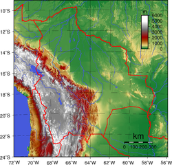
The geology of Bolivia comprises a variety of different lithologies as well as tectonic and sedimentary environments. On a synoptic scale, geological units coincide with topographical units. The country is divided into a mountainous western area affected by the subduction processes in the Pacific and an eastern lowlands of stable platforms and shields. The Bolivian Andes is divided into three main ranges; these are from west to east: the Cordillera Occidental that makes up the border to Chile and host several active volcanoes and geothermal areas, Cordillera Central (in some contexts also called Cordillera Oriental) once extensively mined for silver and tin and the relatively low Cordillera Oriental that rather than being a range by its own is the eastern continuation of the Central Cordillera as a fold and thrust belt. Between the Occidental and Central Cordillera the approximately 3,750-meter-high Altiplano high plateau extends. [1] This basin hosts several freshwater lakes, including Lake Titicaca as well as salt-covered dry lakes that bring testimony of past climate changes and lake cycles. The eastern lowlands and sub-Andean zone in Santa Cruz, Chuquisaca, and Tarija Departments was once an old Paleozoic sedimentary basin that hosts valuable hydrocarbon reserves. Further east close to the border with Brazil lies the Guaporé Shield, made up of stable Precambrian crystalline rock.

Contents

Andes

6,542 meter high Nevado Sajama is one of several volcanoes along Cordillera Occidental Nevado Sajama.jpg
6,542 meter high Nevado Sajama is one of several volcanoes along Cordillera Occidental

The Andes of Bolivia began to rise about 200 million years ago (mya) during the Jurassic. The western margin of what is now South America had been the place of several other orogenies before the Andes rose. It has been hypothesized that the central Andes gained its great height 26 to 14 mya as result of a compressive failure of the lithosphere beneath Bolivia and neighboring areas. [2] The great heights of the Altiplano, Codillera Occidental and Cordillera Oriental are isostatically compensated by an up to 70 km deep crust. Climate has responded to the formation of this important topographic barrier. It is not clear, however, if the rise of the Andes simply caused the extreme aridity of Atacama Desert and adjacent parts of Bolivia or if a preexisting desert climate and associated low erosion rates allowed the mountains to build up to their current heights. [3] [4] [5] [6] A hypothesis holds that scarce sediment supply to the Atacama Trench caused by arid climate induced high shear stresses in the subduction process that enhanced the Andean mountain building. [7]

Western Cordillera

The Western Cordillera is made up by a series of active and extinct volcanoes rising from the western edge of the Altiplano plateau. This range divides the Chilean watersheds of Salar de Atacama and the Pacific from the endorheic Altiplano basin. The western volcanoes of Bolivia are part of the Central Volcanic Zone of the Andes, a major upper Cenozoic volcanic province. [8] Volcanic eruptions in Bolivia are scarce, the latest one occurred in Irruputuncu in 1995. Volcanic hazards do not represent any threat to the major populated centres which are all in the eastern Altiplano or further east, far away from the volcanic centers. Although the Western Cordillera concentrates most active volcanoes (volcanoes active in the last 10000 years) many old large stratovolcanoes rises up to 100 km away from the main line of the Western Cordillera.

Altiplano plateau

Laguna Colorada in the southern Altiplano lies just east of Cordillera Occidental's volcanoes (background mountain). Laguna Colorada 1.jpg
Laguna Colorada in the southern Altiplano lies just east of Cordillera Occidental's volcanoes (background mountain).

The Altiplano plateau or Meseta del Collasuyu to differentiate it from other Andean high plateaux is a wide and long-lived intermontane sedimentary basin with no outlet; it is endorheic. The Altiplano is an infill of sedimentary material from both Cordillera Occidental and Cordillera Oriental. The origin of the Altiplano and its great height has long been major question among geologists. Today the Altiplano is believed to have been an early foreland basin of the "proto-Andes" that got uplifted by crustal shortening in the Late Miocene. [4] [9]

The Bolivian Altiplano hosts the world's largest reserves of lithium. These reserves are in the salt-saturated waters of Salar de Uyuni and Salar de Coipasa, neither of which are currently being commercially exploited for lithium. Salt is extracted from the saltars in minor amounts to be sold as table salt after being added iodine from Chile.

Eastern Cordillera

Erosion landscapes are common in the Central Cordillera and the Sub-Andean Zone Badlands, Bolivia.jpg
Erosion landscapes are common in the Central Cordillera and the Sub-Andean Zone

Cordillera Oriental is made up of a bended arc of plutons. The bend occurs at the latitude of Cochabamba and corresponds to eastward projection of the Arica elbow, the bend of South America's coastline at the Peru-Chile border. North of the bend Cordillera Central's batholiths are northwest-southeast oriented while south of it they are north-south oriented. [10] These bodies of granitic to granodioritic composition were formed in two episodes: the Early Mesozoic (199–180 Ma) and the Neogene (19–8 Ma). The emplacement of these igneous bodies have been interpreted as an effect of two temporary decreases in subduction angles of the ancient Farallon Plate. [11] This arc of magmatic material hosts Bolivia's widely known tin belt as well as the famous silver mine of Potosí. These mineralizations are of the porphyry mineralization type that are typical for convergent plate margins. The Cordillera Real form the northern, highly uplifted and eroded, part of the Central Cordillera.

Lowlands and Sub-Andean zone

To reach the lowlands north of La Paz the Yungas-vegetated Cordillera Oriental has to be passed. Coroico.jpg
To reach the lowlands north of La Paz the Yungas-vegetated Cordillera Oriental has to be passed.

The Sub-Andean Zone and the Northern and Eastern Lowlands share a common ancient history but have since the Andean orogeny developed into two distinct zones. While both zones share essentially the same old sedimentary platform strata, the strata at the Sub-Andean Zone have been folded and thrusted into a fold and thrust belt with structural traps where hydrocarbon fluids have accumulated. The limit between the fold and thrust belt and the Eastern Lowlands is drawn by the Serranía del Aguaragüe, a north-south range representing the Andean thrust front.

Fold and thrust belt

The relatively low Cordillera Oriental, located east of Cordillera Central, are part of a fold and thrust belt and exposes Silurian and Ordovician age strata, some of which are fossil-bearing. The fold and thrust belt makes up the framework of the hydrographic network of Pilcomayo and other rivers. Currently one of Bolivia's most seismic zones is the Cochabamba Fault Zone, located just below the city of Cochabamba and its fertile valley. This fault zone is related to the Arica elbow and the bend in the Andes at this latitude.

Eastern Lowlands

The geology of the eastern lowlands is dominated by the ancient Paleozoic sedimentary ChacoTarija Basin that has considerable hydrocarbon reserves. During the Carboniferous, the Chaco-Tarija Basin was covered by thick sequences that included sandstone filled channels. [12] In the 1970s these sandstone were interpreted as tillite from the late Paleozoic glaciations, but new interpretations consider them to be of marine origin but still glacially influenced. [12] The depositional environment for these channel systems has been likened to that on the floor of the present day Labrador Sea, which was influenced by repeated Pleistocene glaciations. [13] The late Cenozoic deformation associated with the Andean orogeny forced hydrocarbons sourced in Devonian shales to migrate to shallower stratigraphical levels. [14]

Northern Lowlands

The Northern Lowlands are and have long been a depositional milieu and are mostly covered by Tertiary and Quaternary deposits. The bulk of these deposits are now laterites. River erosion and sediment transport have created a large number of oxbow lakes and added copious meanders to the rivers.

Guaporé Shield

In the north and east of Santa Cruz Department the crystalline Precambrian Guaporé Shield (also called Central Brazil Shield) [15] makes up most of the bedrock but is mostly covered by Tertiary laterites and Quaternary alluvial basins. [16] The shield expresses itself topographically as a large elevated hinterland located north of Serranías Chiquitanas towards the Brazilian border. High-grade metamorphic rocks occur in the Bolivian part of the Guaporé Shield partly due to the 2000 million years old "Trans-Amazonian tectonothermal event" that affected parts of South America. Low-grade metamorphic rocks occur as well. The Guaporé Shield is believed to extend beneath the Phanerozoic Tarija-Chaco and Beni Basin sediments into the Andes. It has been suggested that weaknesses in the shield were responsible for the formation of the Arica Elbow.[ citation needed ] The East-West Río Mercedes Line in the Guaporé Shield hosts several Proterozoic diabase intrusions. As of 1985 the rocks of Guaporé Shield were considered to be poorly known. [17] Near the Brazilian border the iron deposit of El Mutún stands out as the world's largest iron ore deposit. [18] It is located in the Serranía de El Mutún, also called Cerro Mutún or Serranía de Jacadigo in Brazil. The shield also underlies Serrania Caparuch or Huanchaca which is the inspiration for the Lost World of Conan Doyle. [19]

Proyecto Precámbrico, [20] an Anglo-Bolivian technical cooperation project, explored the area between 1976 and 1986. There are a series of published 1:250,000 scale maps of the area with accompanying bilingual reports, along with more detailed 1:100,000 maps of regions of economic interest. There is a published geochemical atlas. Most of this data is summarised in an "Overseas Memoir" of the British Geological Survey. [21]

See also

Related Research Articles

<span class="mw-page-title-main">Andes</span> Mountain range in South America

The Andes, Andes Mountains or Andean Mountain Range are the longest continental mountain range in the world, forming a continuous highland along the western edge of South America. The range is 8,900 km (5,530 mi) long, 200 to 700 km wide, and has an average height of about 4,000 m (13,123 ft). The Andes extend from north to south through seven South American countries: Venezuela, Colombia, Ecuador, Peru, Bolivia, Chile and Argentina.

<span class="mw-page-title-main">Geography of Colombia</span> Overview of the geography of Colombia

The Republic of Colombia is situated largely in the north-west of South America, with some territories falling within the boundaries of Central America. It is bordered to the north-west by Panama; to the east by Brazil and Venezuela; to the south by Ecuador and Peru; and it shares maritime limits with Costa Rica, Nicaragua, Honduras, Jamaica, the Dominican Republic, and Haiti.

<span class="mw-page-title-main">Geography of Bolivia</span>

The geography of Bolivia includes the Eastern Andes Mountain Range which bisects Bolivia roughly from north to south. To the east of that mountain chain are lowland plains of the Amazon Basin, and to the west is the Altiplano which is a highland plateau where Lake Titicaca is located. Bolivia's geography has features similar to those of Peru which abuts Bolivia's northwest border; like Bolivia, Peru is bisected from north to south by the Eastern Andes Mountains, and these two countries share Lake Titicaca which is the highest navigable lake on Earth. Unlike Peru, however, Bolivia is one of the two landlocked countries in South America, the other being Paraguay which is located along Bolivia's southeast border.

<span class="mw-page-title-main">Altiplano</span> Large plateau in west-central South America

The Altiplano, Collao or Andean Plateau, in west-central South America, is the most extensive high plateau on Earth outside Tibet. The plateau is located at the latitude of the widest part of the north–south-trending Andes. The bulk of the Altiplano lies in Bolivia, but its northern parts lie in Peru, and its southwestern fringes lie in Chile.

<span class="mw-page-title-main">Cordillera Oriental (Bolivia)</span> Mountain range in Bolivia

The Cordillera Oriental or Eastern Cordillera is a set of parallel mountain ranges of the Bolivian Andes, emplaced on the eastern and north eastern margin of the Andes. Large parts of Cordillera Oriental are forested and humid areas rich in agricultural and livestock products. Geologically, the Cordillera Oriental is formed by the Central Andean fold and thrust belt.

<span class="mw-page-title-main">Foreland basin</span> Structural basin that develops adjacent and parallel to a mountain belt

A foreland basin is a structural basin that develops adjacent and parallel to a mountain belt. Foreland basins form because the immense mass created by crustal thickening associated with the evolution of a mountain belt causes the lithosphere to bend, by a process known as lithospheric flexure. The width and depth of the foreland basin is determined by the flexural rigidity of the underlying lithosphere, and the characteristics of the mountain belt. The foreland basin receives sediment that is eroded off the adjacent mountain belt, filling with thick sedimentary successions that thin away from the mountain belt. Foreland basins represent an endmember basin type, the other being rift basins. Space for sediments is provided by loading and downflexure to form foreland basins, in contrast to rift basins, where accommodation space is generated by lithospheric extension.

<span class="mw-page-title-main">Andean Volcanic Belt</span> Volcanic belt in South America

The Andean Volcanic Belt is a major volcanic belt along the Andean cordillera in Argentina, Bolivia, Chile, Colombia, Ecuador, and Peru. It is formed as a result of subduction of the Nazca Plate and Antarctic Plate underneath the South American Plate. The belt is subdivided into four main volcanic zones which are separated by volcanic gaps. The volcanoes of the belt are diverse in terms of activity style, products, and morphology. While some differences can be explained by which volcanic zone a volcano belongs to, there are significant differences within volcanic zones and even between neighboring volcanoes. Despite being a type location for calc-alkalic and subduction volcanism, the Andean Volcanic Belt has a broad range of volcano-tectonic settings, as it has rift systems and extensional zones, transpressional faults, subduction of mid-ocean ridges and seamount chains as well as a large range of crustal thicknesses and magma ascent paths and different amounts of crustal assimilations.

<span class="mw-page-title-main">Geology of Colombia</span>

Geology of Colombia refers to the geological composition of the Republic of Colombia that determines its geography. Most of the emerged territory of Colombia covers vast areas within the South American plate, whereas much submerged territory lies within the Caribbean plate and the Nazca plate.

<span class="mw-page-title-main">Andean orogeny</span> Ongoing mountain-forming process in South America

The Andean orogeny is an ongoing process of orogeny that began in the Early Jurassic and is responsible for the rise of the Andes mountains. The orogeny is driven by a reactivation of a long-lived subduction system along the western margin of South America. On a continental scale the Cretaceous and Oligocene were periods of re-arrangements in the orogeny. The details of the orogeny vary depending on the segment and the geological period considered.

<span class="mw-page-title-main">Cerro Cañapa</span> Mountain in Bolivia

Cerro Cañapa is an elongated mountain in Bolivia, with a height of 5882 m, close to the border with Chile. Note that the international border in this area is a straight line that runs from Cerro Araral to Ollagüe, leaving Cerro Cañapa completely in Bolivian territory.

<span class="mw-page-title-main">Geology of North America</span> Overview of the geology of North America

The geology of North America is a subject of regional geology and covers the North American continent, the third-largest in the world. Geologic units and processes are investigated on a large scale to reach a synthesized picture of the geological development of the continent.

<span class="mw-page-title-main">Cerro Panizos</span>

Panizos is a Late Miocene caldera in the Potosí Department of Bolivia and the Jujuy Province of Argentina. It is part of the Altiplano-Puna volcanic complex of the Central Volcanic Zone in the Andes. 50 volcanoes active in recent times are found in the Central Volcanic Zone, and several major caldera complexes are situated in the area. The caldera is located in a difficult-to-access part of the Andes.

<span class="mw-page-title-main">Altiplano Basin</span> Sedimentary basin within the Andes in Bolivia and Peru

The Altiplano Basin is a sedimentary basin within the Andes in Bolivia and Peru. The basin is located on the Altiplano plateau between the Cordillera Occidental and the Cordillera Oriental. Over-all the basin has evolved through time in a context of horizontal shortening of Earth's crust. The great thickness of the sediments accumulated in the basin is mostly the result of the erosion of Cordillera Oriental.

Lauca is a 5,140 metres (16,860 ft) high andesitic stratovolcano in the Central Volcanic Zone of the Andes on the Altiplano in northern Chile. Administratively it is located in Putre, Arica y Parinacota Region. The volcano was active during the Late Miocene from 10.5 million years ago onwards. A major ignimbrite collapsed the volcano in the Late Pliocene.

Los Frailes is an ignimbrite plateau in Bolivia, between the city of Potosi and the Lake Poopo. It belongs to a group of ignimbrites that exist in the Central Andes and which includes the Altiplano–Puna volcanic complex. The plateau covers a surface of 7,500 square kilometres (2,900 sq mi)–8,500 square kilometres (3,300 sq mi) with about 2,000 cubic kilometres (480 cu mi) of ignimbrite.

The geology of Venezuela includes ancient Precambrian igneous and metamorphic basement rocks, layered with sedimentary rocks from the Paleozoic and Mesozoic and thick geologically recent Cenozoic sediments with extensive oil and gas.

The geology of Argentina includes ancient Precambrian basement rock affected by the Grenville orogeny, sediment filled basins from the Mesozoic and Cenozoic as well as newly uplifted areas in the Andes.

<span class="mw-page-title-main">Geology of Peru</span>

The geology of Peru includes ancient Proterozoic rocks, Paleozoic and Mesozoic volcanic and sedimentary rocks, and numerous basins and the Andes Mountains formed in the Cenozoic.

<span class="mw-page-title-main">Salar de Punta Negra</span> Saltpan in Antofagasta Region, Chile

Salar de Punta Negra is a saltpan in the Antofagasta Region of Chile with a surface area of about 230 square kilometres (89 sq mi). It is surrounded by deposits left by dry valleys that descend the Western Cordillera. These dry valleys, from mountains such as the Llullaillaco volcano, carry water only occasionally. More permanent sources of water, in the form of springs, also exist at Salar de Punta Negra.

References

  1. "The Use of Solar Energy for Improving the Living Conditions in Altiplano/Argentina" (PDF). Archived from the original (PDF) on 2011-07-19. Retrieved 2010-05-25.
  2. Geology of the Altiplano, Oregon State University
  3. Neogene climate change and uplift in the Atacama Desert, Chile
  4. 1 2 Garcia-Castellanos, D., 2007. The role of climate in high plateau formation. Insights from numerical experiments. Earth Planet. Sci. Lett. 257, 372–390, doi:10.1016/j.epsl.2007.02.039
  5. Tectonics and Climate of the Southern Central Andes, Annual Review of Earth and Planetary Sciences, 2007.
    Cite: "precipitation and erosion may influence the kinematics and locus of tectonic activity in orogens."
  6. David R. Montgomery, Greg Balco and Sean D. Willett. 2001 Climate, tectonics, and the morphology of the Andes
    Cite: "...like tectonics, nonuniform erosion due to large-scale climate patterns is a first-order control on the topographic evolution of the Andes."
  7. Lamb and Davis. 2003. Cenozoic climate change as a possible cause for the rise of the Andes, Nature
  8. Baker, M.C.W; Francis, P.W (1978), "Upper Cenozoic Volcanism in the Central Andes – Ages and Volumes", Earth and Planetary Science Letters, 41 (2): 175, Bibcode:1978E&PSL..41..175B, doi:10.1016/0012-821X(78)90008-0
  9. Lamb, Hoke, Kennan, Dewey. 1996. Cenozoic evolution of the Central Andes in Bolivia and northern Chile.
  10. Hydrothermal Processes and Mineral Systems. Pages 376–381.
  11. Sandra L. McBride, Ronald C. R. Robertson, Alan H. Clark and Edward Farrar. 1983.Magmatie and Metallogenetie Episodes in the Northern Tin Belt, Cordillera Real, Bolivia. Geologische Rundschau. Vol. 72.
  12. 1 2 A. J. Tankard; Ramiro Suárez Soruco; Herman J. Welsink (1995). Petroleum Basins of South America. American Association of Petroleum Geologists. p. 175. ISBN   978-0-89181-341-5.
  13. A. J. Tankard; Ramiro Suárez Soruco; Herman J. Welsink (1995). Petroleum Basins of South America. American Association of Petroleum Geologists. p. 180. ISBN   978-0-89181-341-5.
  14. A. J. Tankard; Ramiro Suárez Soruco; Herman J. Welsink (1995). Petroleum Basins of South America. American Association of Petroleum Geologists. p. 178. ISBN   978-0-89181-341-5.
  15. Litherland, M; Bloomfield, K (1981), "The proterozoic history of eastern Bolivia", Precambrian Research, 15 (2): 157, Bibcode:1981PreR...15..157L, doi:10.1016/0301-9268(81)90027-9
  16. METALLIFEROUS ORE DEPOSITS OF BOLIVIA
  17. Jones, J.P (1985), "The southern border of the Guaporé Shield in western Brazil and Bolivia: An interpretation of its geologic evolution", Precambrian Research, 28 (2): 111–135, Bibcode:1985PreR...28..111J, doi:10.1016/0301-9268(85)90076-2
  18. "Serrania Mutun, Chiquitos Province, Santa Cruz Department, Bolivia". mindat.org. Retrieved 2006-10-20.
  19. The geologic and geomorphic evolution of Serrania Huanchaca, eastern Bolivia: the legendary 'Lost World'. M Litherland and G Power: Journal of South American Earth Sciences, Vol 2, No 1, 1–17, 1989.
  20. Mathers, S J, ed. (1991). "BGS Technical Cooperation in Latin America (1965–90)" (PDF). British Geological Survey Technical Report (WC191125): 19–28. Archived from the original (PDF) on 13 November 2006. Retrieved 8 April 2017.
  21. The Geology and Mineral Resources of the Bolivian Precambrian Shield. M Litherland and others: Overseas Memoir 9, British Geological Survey, Her Majesty's Stationery Office, 1986.