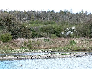
WWT Washington Wetland Centre is a wetland reserve managed by the Wildfowl and Wetlands Trust at Washington, Tyne and Wear, North East England.

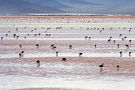
The Andean flamingo is a species of flamingo native to the Andes mountains of South America. Until 2014, it was classified in genus Phoenicopterus. It is closely related to James's flamingo, and the two make up the genus Phoenicoparrus. The Chilean flamingo, Andean flamingo, and James' flamingo are all sympatric, and all live in colonies.

Lake Natron is a salt or alkaline lake located in north Ngorongoro District of Arusha Region in Tanzania. It is in the Gregory Rift, which is the eastern branch of the East African Rift. The lake is within the Lake Natron Basin, a Ramsar Site wetland of international significance.

James's flamingo, also known as the puna flamingo, is a species of flamingo that lives at high altitudes in the Andean plateaus of Peru, Chile, Bolivia, and northwest Argentina.

Lake Poopó was a large saline lake in a shallow depression in the Altiplano Mountains in Oruro Department, Bolivia, at an altitude of approximately 3,700 m (12,100 ft). Because the lake was long and wide, it made up the eastern half of the department, known as a mining region in southwest Bolivia. The permanent part of the lake body covered approximately 1,000 square kilometres (390 sq mi) and it was the second-largest lake in the country. The lake received most of its water from the Desaguadero River, which flows from Lake Titicaca at the north end of the Altiplano. Since the lake lacked any major outlet and had a mean depth of less than 3 m (10 ft), the surface area differed greatly seasonally.

A Ramsar site is a wetland site designated to be of international importance under the Ramsar Convention, also known as "The Convention on Wetlands", an intergovernmental environmental treaty established in 1971 by UNESCO, which came into force in 1975. It provides for national action and international cooperation regarding the conservation of wetlands, and wise sustainable use of their resources. Ramsar identifies wetlands of international importance, especially those providing waterfowl habitat.

Laguna Verde is a salt lake in an endorheic basin, in the southwestern Altiplano in Bolivia. It is located in the Sur Lípez Province of the Potosí Department. It is close to the Chilean border, at the foot of the volcano Licancabur.

Sur Lípez or Sud Lípez is a province in the Potosí Department in Bolivia. The seat of the province is San Pablo de Lípez.
Lagunas de Mejía National Sanctuary is a protected area on the coastal plain of Peru, in Islay Province, Arequipa, in the mouth of the Tambo River. It is a sanctuary for migratory and resident birds, and was designated a Ramsar site in 1992.

Nevado Tres Cruces National Park is a national park located in the Atacama Region of Chile, east of Copiapó. It includes Laguna Santa Rosa, Laguna del Negro Francisco, and a part of the Salar de Maricunga. The park is divided into two zones, the northern zone encompassing the southern portion of Salar de Maricunga and Laguna Santa Rosa, and the southern area the Laguna del Negro Francisco. The park is named after Nevado Tres Cruces, which dominates the landscape of the area. The park is managed by the Corporación Nacional Forestal, which offers two refuges in the area: one at the south of Negro Francisco Lagoon and other at the west of Santa Rosa Lagoon. The park is open from October to April.

Los Flamencos National Reserve is a nature reserve located in the commune of San Pedro de Atacama, Antofagasta Region of northern Chile. The reserve covers a total area of 740 square kilometres (290 sq mi) in the Central Andean dry puna ecoregion and consists of seven separate sections.

The Central Andean dry puna (NT1001) is an ecoregion in the Montane grasslands and shrublands biome, located in the Andean high plateau, in South America. It is a part of the Puna grassland.

The Eduardo Avaroa Andean Fauna National Reserve is located in Sur Lípez Province. Situated in the far southwestern region of Bolivia, it is the country's most visited protected area. It is considered the most important protected area in terms of tourist influx in the Potosí Department.

Laguna Hedionda is a saline lake in the Nor Lípez Province, Potosí Department in Bolivia. It is notable for various migratory species of pink and white flamingos.

Laguna de la Restinga is a national park on the Isla Margarita, Nueva Esparta state, Venezuela. The main part of the park is a large salt lagoon, rich in fish and birdlife. It is on the Ramsar list of wetlands of international importance, and is classified as an Important Bird Area.
The Memorandum of Understanding (MoU) on the Conservation of High Andean Flamingos and their Habitats is a multilateral environmental memorandum of understanding that was concluded under the auspices of the Convention on Migratory Species of Wild Animals (CMS), also known as the Bonn Convention. The MoU came into effect on 4 December 2008 and provides protection for the populations of high Andean flamingos, which have been subject to drastic reduction and fragmentation of their habitats and have a delicate state of conservation. The MoU covers four range states. As of August 2012, three range states have signed the MoU.

Nelly is a stratovolcano in the Andes located in the Cordillera Occidental of Bolivia, about 5,676 m (18,622 ft) high. It is situated within the Eduardo Avaroa Andean Fauna National Reserve, north east of the Licancabur volcano, Laguna Verde and Laguna Blanca and next to Mount Laguna Verde in the Potosí Department, Sur Lípez Province, San Pablo de Lípez Municipality, Quetena Grande Canton.
Laguna Colorada Airport is an extremely high elevation airstrip just south of Laguna Colorada, a shallow salt lake within the Eduardo Avaroa Andean Fauna National Reserve in the southwest of the Bolivian altiplano,.

Laguna Vilama is a salt lake in northwestern Argentina, within the Vilama caldera. It is shallow and covers a surface area of 4,590 hectares.
Laguna salada may refer to: